Tel Zemed, Tel Saharon and Tel Malluah – ancient sites in the Jordan valley, en route from Beit Shean to the Transjordan city of Jabesh Gilead.
Home > Sites > Jordan Valley > Tels Zemed, Saharon, Malluah
Contents:
Background
Location
History
Photos
* Nahal Avuqa
* Tel Zemed
* Tel Saharon
* Tel Malluah
Etymology
Links
Background:
This page reviews Tel Zemed, Tel Saharon and Tel Malluah – multi-period archaeological sites located along the Avuqa stream (wadi el Jizil), south east of Beit Shean, on the route to ancient crossings of the Jordan River.
These sites were visited as part of BibleWalks Jordan Valley survey.
Location:
Tel Zemed is located 2km south east of the modern city of Beit Shean. It rises over the southern bank of the stream of Nahal Avuqa (Wadi el-Jizil).
Downstream on Nahal Avuqa, closer to the Jordan river, are 2 sites – Tel Saharon (1km south west of Kfar Ruppin) and Tel Malluah (1 km south of Kfar Ruppin). The ancient route, guarded by Tel Malluah, crossed the river at the ford of Umm el Hajar.
History:
- Bronze and Iron periods (3,150-1,200 BC, 1,200-586 BC)
According to the ceramics found on Tel Zemed and Tel Malluah, their main settlement periods were during the Late Bronze and Iron Age periods.
-
Biblical map
The cities and roads during the Bronze/Canaanite and Iron/Israelite periods are indicated on the Biblical Map below. The major sites in the area west of the Jordan river include Rechov (the major Iron Age II city) and Beit Shean.
The location of the sites reviewed in this page are marked by red dots on the west bank of the Jordan river. They were located on the side of an ancient road (marked as a dashed line) from Beit Shean, via the fords of the Jordan river, to Jabesh Gilead and beyond.
Map of the area of Beit Shean valley – during the Canaanite and Israelite periods (based on Bible Mapper 3.0)
- Jabesh Gilead
The Iron Age road passing near Tel Zamed and Tels Saharon and Malluah continued east of the Jordan river, passing thru the Biblical city of Jabesh Gilead. One of the key events involving this city is found in the Bible (1 Samuel:11). In this narrative, Nahash the Ammonite, an enemy of the Israelites, laid siege to Jabesh Gilead. The inhabitants of the city were in a desperate situation, and they sought terms of surrender from Nahash [BW: Hebrew for Snake]. Nahash, however, imposed a humiliating condition on them. He offered to make a covenant with the people of Jabesh Gilead but demanded that he would gouge out the right eye of each of the city’s inhabitants as a sign of their submission.
News of this dire situation reached King Saul, who was anointed as the first king of Israel. Upon hearing about the plight of the people of Jabesh Gilead, Saul took immediate action. He gathered an army, and with great speed and strategy, he led a rescue mission to the city. The Israelite forces defeated Nahash the Ammonite, saving the people of Jabesh Gilead and establishing Saul’s reputation as a capable and charismatic leader.
The story of Saul’s rescue of Jabesh Gilead is seen as a significant event in the early history of Israel and contributes to his rise in prominence as the king. The people of Jabesh Gilead were very grateful to Saul for saving them from such a dire fate.
This gratitude was reciprocated years later when King Saul died. After Saul’s death and the death of his sons in a battle against the Philistines, the Philistines hung their bodies on the wall of the city of Beit Shean. When the people of Jabesh Gilead heard about this, they demonstrated their loyalty to Saul and their gratitude for his earlier rescue by embarking on a daring and dangerous mission. They journeyed to Beit Shean, retrieved the bodies of Saul and his sons, and gave them a proper burial.
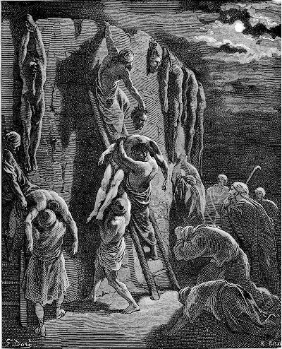
Saul and sons bodies removed from the walls of Bethshean –
Drawing by Gustav Dore (French artist, 1832-1883)
This act of retrieving and burying Saul’s remains was a sign of their respect and remembrance of the king who had come to their aid in their time of need. The story of the people of Jabesh Gilead’s actions in retrieving and burying Saul and his sons is recounted in 1 Samuel:31.
- Jordan river crossing
In the antiquity the Jordan river crossings was by crossing fords along the river rather than using bridges or ferries. Bridges were constructed only during the Roman and Mameluke periods. Dorsey (“The roads and Highways of Ancient Israel”) claims that no Bronze or Iron Age bridges were found along the Jordan, and the Bible does not mention such bridges.
David Dorsey (“The roads and Highways of Ancient Israel”, 2018, pp. 104, 110-112, 115-116) listed 2 Iron age roads that came through the sites:
- T11a – From Samaria via Jenin and Faqua on the Gilboa, passing near Tel Rehov to Jisr esh Sheikh Hasin (modern border crossing at Sheikh Hussein). It connected Tel Zemed (Tell esh Sheikh es Simad – site #254) to Tel Nimrud (site #246), then to the fords along the Jordan river – such as Tel ‘Artal and Tel Karpas near Kfar Ruppin.
- T7c – a southern branch led southeast from Beit Shean to the fords along the Jordan river. It passed near Tel ‘Artal (site #253) and Tel Zemed (Tell esh Sheikh es Simad – site #254).
- Byzantine period
The major settlement period on Tel Saharon was during the Byzantine period. During the Crusaders a sugar cane factory operated on the site.
-
Later periods
During the late Ottoman period the ancient mound of Tel Zemed served as a Muslim cemetery, as the place was near a Sheikh’s tomb (esh Semad).
The site was examined in the PEF survey (1866-1877) by Wilson, Conder and Kitchener. They wrote about the site merely (Vol 2 , p. 128):
“Tell esh Sheikh Semad (P k).—Artificial mound, with a stream of water”.
A section of their map is shown here. The site is marked as Sheikh es Semad.
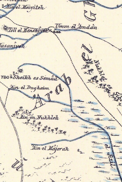
Part of Map sheet 9 of Survey of Western Palestine,
by Conder and Kitchener, 1872-1877.
(Published 1880, reprinted by LifeintheHolyLand.com)
Downstream along the Avuqa stream (el Jizil) is another ancient city – Tel Saharon – located on the south side of Saharon spring that fed into the stream. Its major period of settlement was during the Byzantine period. It is also located at the side of the ancient route thru the fords on the Jordan river. The river crossings (marked as Mak.t – short for Makhadet – Arabic for ‘ford’) appears as lines across the Jordan river. The map shows a large number of fords that were used for the river crossings.
Another ancient site near the ford crossing point is Tel Malluah (Tell el Jizil), located near the mouth of the stream. The crossing points are “Mak.t Umm el Hajar” (on the north bank of the stream), and “Mak.t Akleh (on the south bank).
Part of Map sheet 9 of Survey of Western Palestine,
by Conder and Kitchener, 1872-1877.
(Published 1880, reprinted by LifeintheHolyLand.com)
- British Mandate
A 1940s British map shows the area around Tel Zemed (Tell esh Sh. Smad”) with more details. The stream continues south east towards the Jordan river, and is named Wadi el-Jizil (PEF translation: ‘cut off’ valley). The Sheikh tomb (Esh Sh. Smad) was located until the 1970s west of the mound.
An abandoned locality, Kibbutz Avuqa, is located east of the site, within the green area. It was established in 1941, suffered from internal social conflicts, and was abandoned in 1952.
The name Avuqa (אבוקה), meaning ‘torch’ in Hebrew, remained as the name of the stream (here marked as el Jizil – named after a nearby abandoned Arab village).
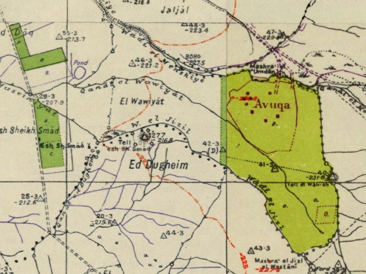
British survey map 1942-1948 – https://palopenmaps.org topo maps
License: public domain under the UK Copyright, Designs and Patent Act 1998
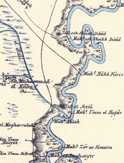
The sites of Tel Saharon (here – Tell esh Sh. Muhammed) and Tel Malluah (here – Tell el Qitaf) are shown below on another section of the 1940s map. The ford is named here differently as “Makhedat Tureikhim”.
British survey map 1942-1948 – https://palopenmaps.org topo maps
License: public domain under the UK Copyright, Designs and Patent Act 1998
-
Modern Times
The sites are open to the public, and the stream and its pools are popular places during the summer weekends.
In 2017 the artists Rafi and Efrat Nathan of Kfar Ruppin created a metal sculpture of the people of Jabesh Gilead carrying the body of King Saul from the walls of Beit Shean for proper burial in their land. The council of Emek HaMaayanot (“Valley of Springs”) constructed the structure on the summit of Tel Zemed.
Photos:
(a) Nahal Avuqa (Wadi Masil el-Jizl)
The stream of Nahal Avuqa starts from the spring of Ein Zemed, located near the ancient site. The spring was the source of its water supply. It continues east towards the Jordan valley.
Click on the photos to view in higher resolution
Pools along the stream are great places for swimming and picnics.
The creek can be crossed in some sections.
The ancient mound overlooks the spring and the creek. This view was taken from the summit towards the north east.
(b) Tel Zemed
The mound rises above the spring of Ein Zemed (‘Ain esh Sheikh Semad).
The ancient site covers a total area of 10 dunams, and the summit covers an area of 20 x 30m.
- Sculpture
On the summit is a metal sculpture, depicting the people of Jabesh Gilead carrying the body of King Saul from the walls of Beit Shean for proper burial in their land. The people of Jabesh-Gilead paid a final debt of gratitude to the fallen King, as Saul rescued them 16 years earlier from Nahash the Ammonite.
The Bible wrote about this event that followed the death of King and his sons in the battle with the Philistines, and displayed their bodies on the walls of Beit Shean (1 Samuel 31:10-13):
“…and they fastened his body to the wall of Bethshan. And when the inhabitants of Jabeshgilead heard of that which the Philistines had done to Saul; All the valiant men arose, and went all night, and took the body of Saul and the bodies of his sons from the wall of Bethshan, and came to Jabesh, and burnt them there. 13And they took their bones, and buried them under a tree at Jabesh, and fasted seven days.”.
Tel Zemed is located on their route – in the middle between Beit Shean and Jabesh-Gilead.
A large porcupine hole was opened on the summit. The rodents unearthed layers of the mound, revealing pottery and bones.
A view of the layers opened by the porcupine is in the next photo. This cut revealed remains of a sun dried mud brick – the building block of walls and structures in the Bronze and Iron age.
Another sun dried mud brick was found during our survey.
- Views:
The ancient route from Beit Shean towards the fords of the Jordan river passed on the western side of the spring. In the following view, aimed towards the north west, are the outskirts of the modern city of Beit Shean. This is seen on the left background.
Closer, to the east (right) of Beit Shean, is Tel Nissa – a Canaanite/Israelite city built on a large artificial mound. Its summit, seen here in the center background, rises above the area.
About 200m west of the site was the tomb of Sheikh es Semad, within a number of Sheizaf trees (Ziziphus spina-christi). Near the tomb, Zori reported (1962) pottery remains of the Byzantine and Early Muslim period. The tomb was demolished in the 1970s.
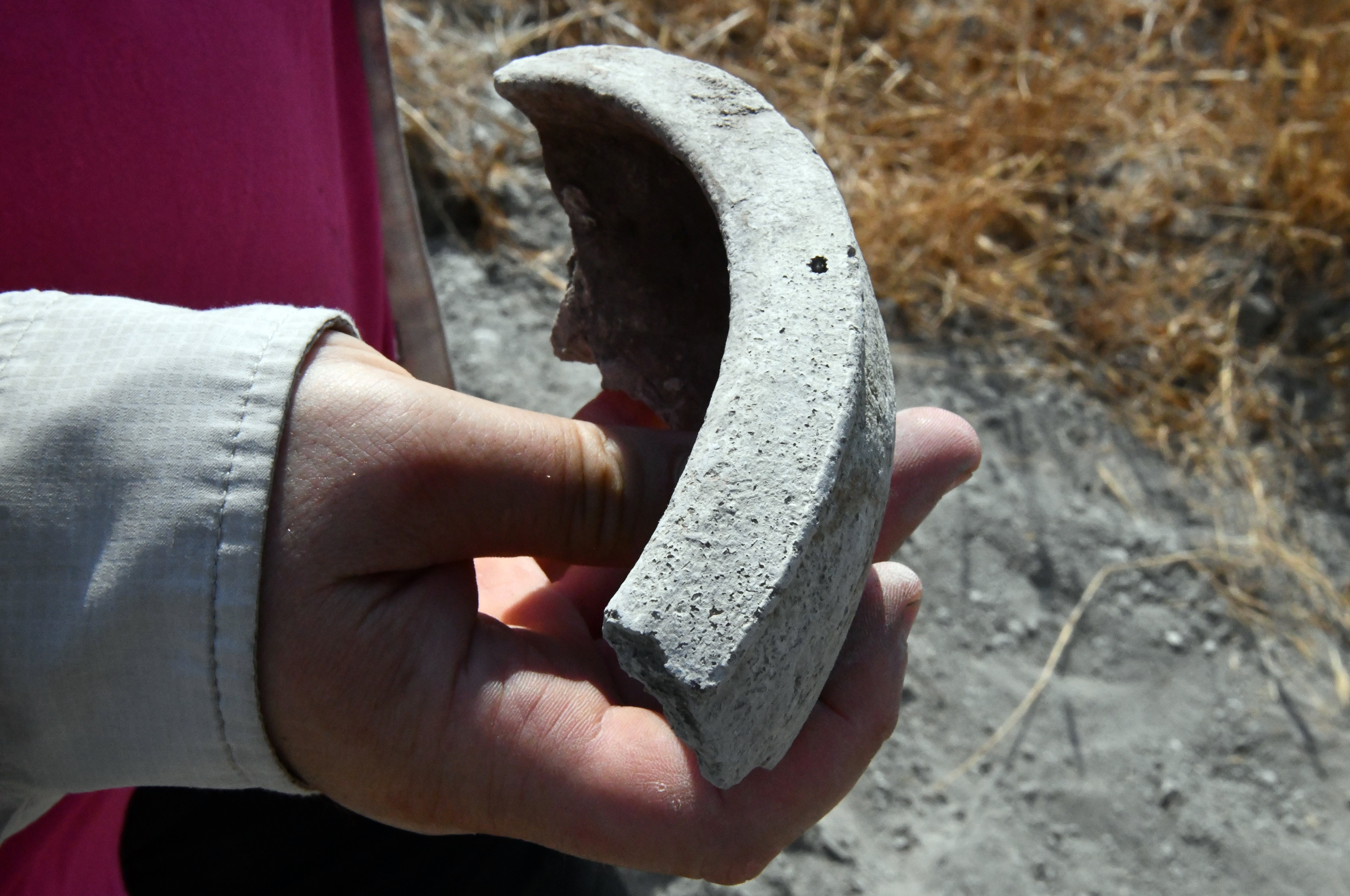
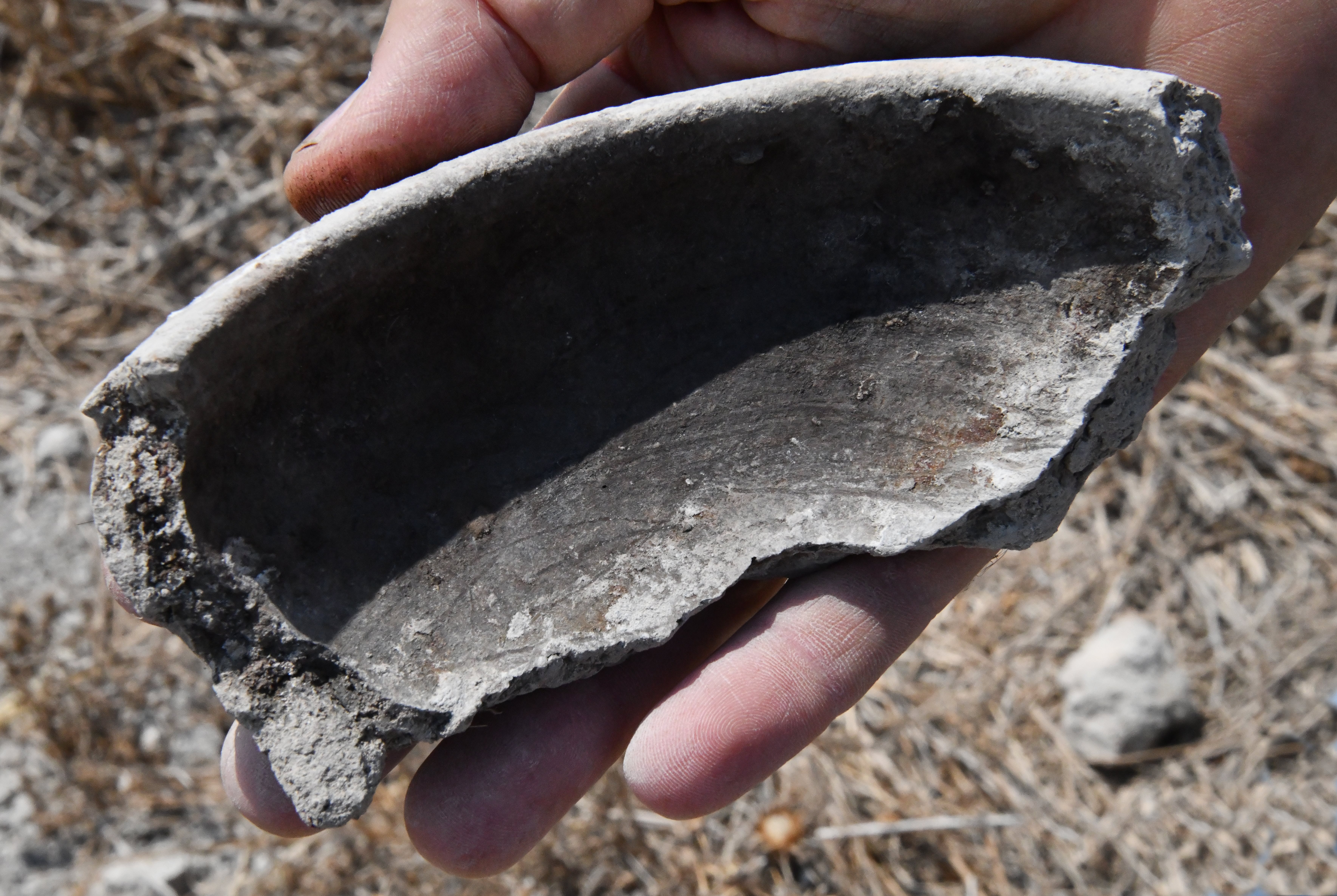
- Ceramics:
Past surveys (N. Zori, 1962, site 90; A. Cohen-Tabor, site 69 ) dated the ceramics to the Early Bronze I (few), Late Bronze (many), Iron Age I (many) and II, Persian (on the south east foothill), Hellenistic, Byzantine, Early Muslim and Mameluke periods.
In our short survey on the mound, led by archaeologist Ayelet Goldberg-Keidar, we have dated the ceramics we collected (and leaving them on the site). Almost all the pottery was date to the Iron Age IIa (1000-925 BC). Here are some of the items:
1. Iron Age – late IIa (or early IIb)
2. Iron Age IIa (late years)
3. Iron age II
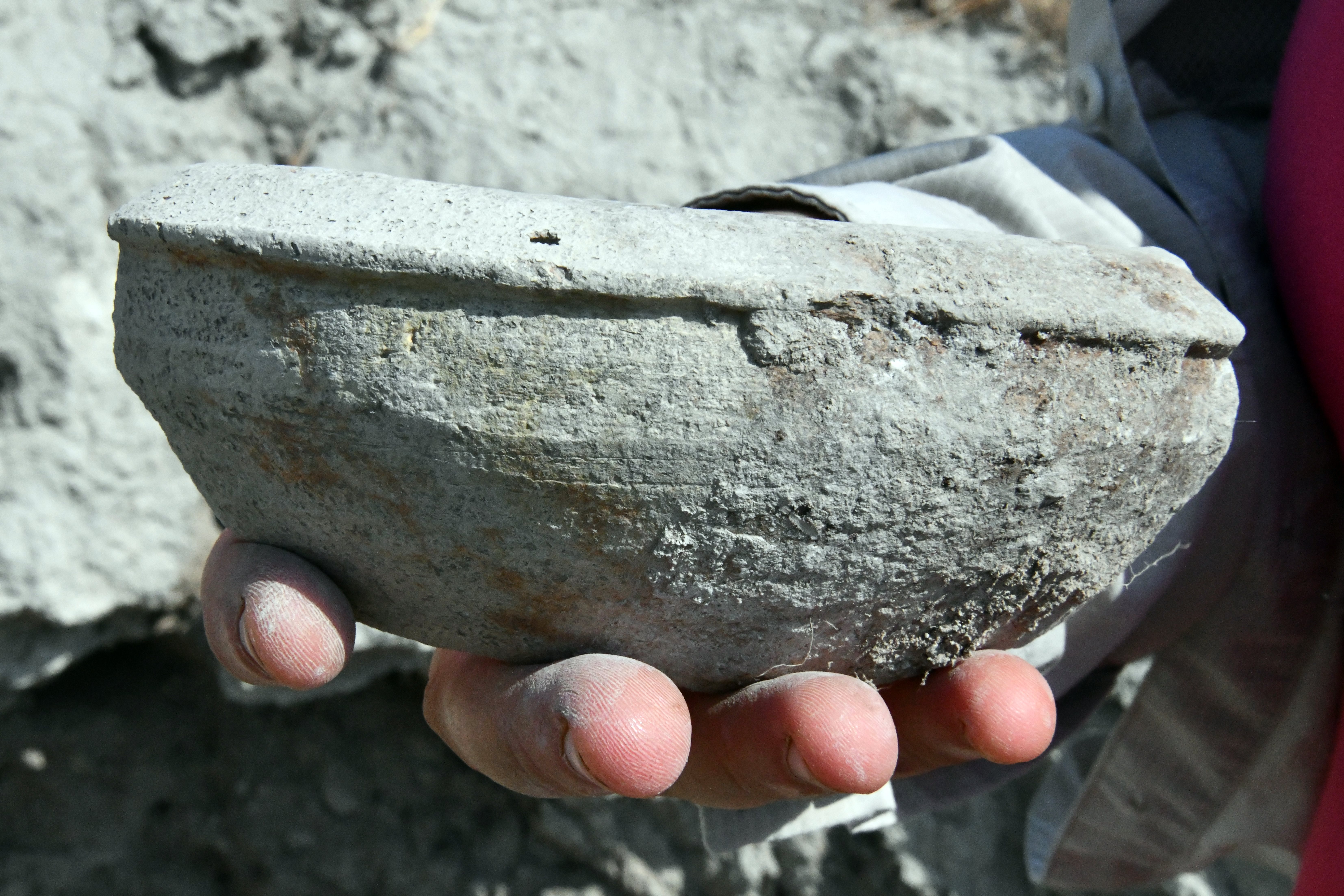
4. Iron Age II
5. Iron Age IIa
(c) Tel Saharon
Another ancient site is located 3km south south east of Tel Zemed. Tel Saharon (Tell Esh Sh. Muhammed, Sh. Muhammed el Kabu) is a larger (100 dunam) site, south of the spring of Ein Saharon. This city was also located on the route to the river crossings.
N. Zori dated the ceramics (1962: site 75) to the following periods: Persian, Hellenistic, Roman/Byzantine (major period), early Muslim, Crusaders, Abbasside and Mameluke. Remains of a Crusaders period sugar cane factory was found on the west side of the spring.
A bird ringing station is located on the west side of Tel Saharon. It is part of the Saharon nature reserve area covering an area of 55 dunams.
(d) Tel Malluah
Tel Malluah (Tell el-Jizl, Tell el Qitaf) is a small Biblical site situated on a hill overlooking the al-Zhor descent. The site is 1.2km south east of Tel Saharon. Its size is 75m by 55m.
This ancient city guarded the nearby river crossing on the ford named Umm al Hajar (“Mother of stones”).
The site was heavily damaged by a military fortifications, built to protect the border with Jordan.
The first outpost was built in 1956, damaging the eastern section of the mound. The construction revealed structures built of mud bricks, Iron Age I pottery and a Bronze axe.
During the years 1967-1970 the Jordan valley area was hit by frequent terrorist infiltrations, and the army took control of many archaeological mounds to monitor and protect the country.
The Hebrew name of the site, Malluah (מלוח) is named after the local “salty” plant (“saltbush”, Atriplex) that grows here. This plant is tolerant for severe conditions of drought, and can grow easily in very alkaline and saline soils. The leaves are edible. The Bible tells on the poor people returning from the Babylonian exile who fed on these plants (Job 30:4): “הַקֹּטְפִים מַלּוּחַ עֲלֵי-שִׂיחַ” meaning: “Who cut up mallows by the bushes, and juniper roots for their meat”.
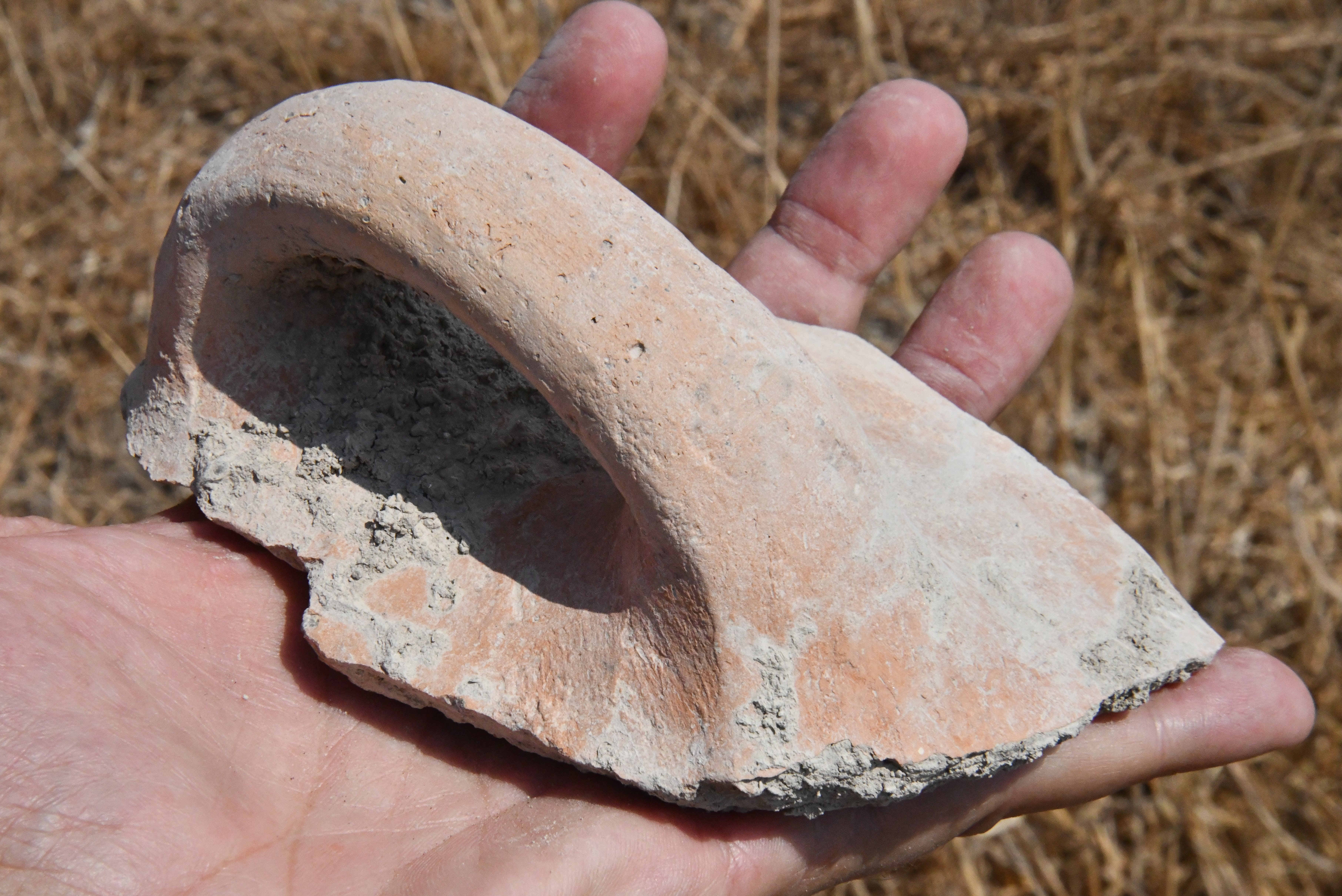
N. Zori dated the ceramics (1962: site 61) to the following periods: Intermediate Bronze, Middle Bronze II, Late Bronze, Iron I, Iron IIa, Hellenistic, Byzantine. Flint stones were dated to the Chalcolithic period.
During our survey we found few pottery remains, and dated one:
6. Iron Age IIa (1000-925 BC)
Etymology (behind the name):
- Tel (Tell) – mound (See more on the story of a Tel).
- Makhadet – Arabic: Ford
- Tell esh Sheikh es Simad – Arabic name of Tel Zemed;
- Tel Zemed: Zemed in Hebrew means pair (צמד). The modern Hebrew name was based on the Arabic name (Semad).
- Sheikh es Semad: PEF dictionary: a private name, means ‘fighting’
- Avuqa (אבוקה) – ‘torch’ in Hebrew, a stream named after an abandoned settlement in the area on its north side
- Masil al-Jizl – An Arab village that was located nearby until 1948; the stream is named after it (now named in Hebrew: Nahal Avuqa)
- Saharon: Hebrew; meaning: Lune, Crescent.
- Sheikh Muhammcd el Kabu – Sheikh Mohammed of the Dome.
- Malluah – Hebrew: meaning salty (a bush -“saltbush”, Atriplex)
- Umm el Hajar – Arabic: Mother of stones
Links:
* General links:
- Survey of Tel Rechov area – Tel Zemed – Ahia Cohen-Tavor , 2010, Hebrew Univ, Hebrew (Zemed: site 69; Saharon: site 72, Malluah: site 61).
- N. Tzori 1962 – Tel Zemed – site 90; Tel Saharon – site 75. Malluah – site 75.
- Tel Zemed sculpture Kibbutz MyNet (1/8/2017)
* Other River Crossing sites:
* Internal links:
BibleWalks.com – exploring the ancient sites of Israel
Tel Tsaf and Gamma<<<—previous site—<<< All Sites>>> — Next site—>>>Tels Eshtori, Nimrud, Midrash, Zofim
This page was last updated on Oct 22, 2023 (add map and texts related to 2 more sites)
Sponsored links: