Bronze/Iron age sites in the Jordan valley, on the route from Beit Shean to the Jordan river crossing at Sheikh Hussein. Including Tels Eshtori, Nimrod, Midrash, Zofim.
Home > Sites > Jordan Valley > Tel Eshtori, Nimrud, Midrash, Zofim
Contents:
Background
Location
History
Identification
The sites
Photos
* Tel Eshtori
* Tel Midrash
* Tel Nimrod
* Tel Zofim
Etymology
Links
Background:
This web page reviews Bronze/Iron age sites along the central branch of the road from Beit Shean to the Jordan river crossing point on the fords near Sheikh Hussein (where the modern border crossing point is to Jordan). These are the sites, all small Bronze/Iron age mounds:
- Tel Eshtori (Tell el Maliha), west of Kibbutz Neve Eitan
- Tel Nimrod (Tell Nimrud), south of Kibbutz Maoz Haim.
- Tel Midrash (Tell el Madrasa), east of Kibbutz Maoz Haim.
- Tel Zofim, west of Sheikh Hussein.
Location:
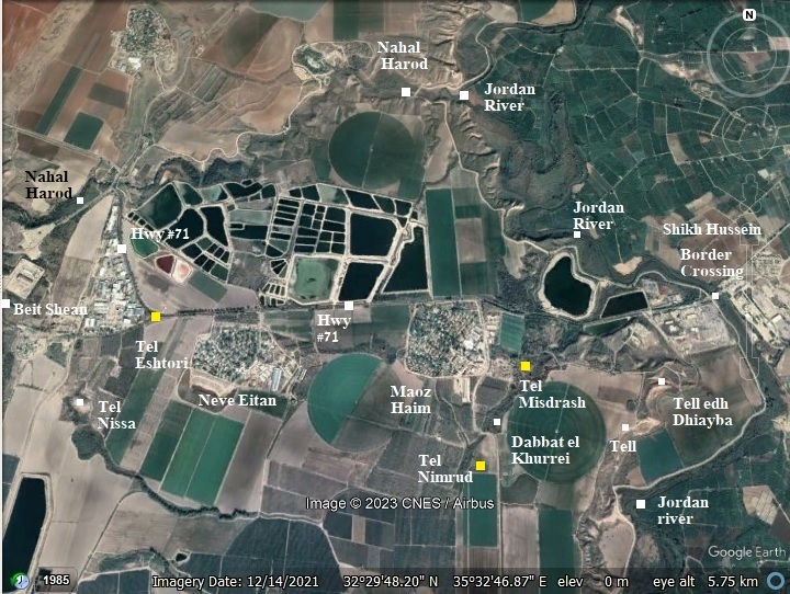
The Biblical mounds reviewed in this page were located were along one of the ancient routes from Beit Shean to the Jordan river crossing at the ford of Sheikh Hussein. Today this road is highway #71, connecting Beit Shean to the border crossing.
The reviewed sites are marked with yellow squares.
Except for Tel Eshtori, all of the sites reviewed here are situated along the stream of Tel Nissa – named Menshiyeh stream (or its modern name – Nahal Eitan).
History:
The sites reviewed in the page were settled in the Bronze and Iron Age periods.
-
Biblical map
The cities and roads during the Canaanite and Israelite periods are indicated on the Biblical Map below, focusing on the area of the valley Beit Shean – a northern section along the Jordan valley.
The sites reviewed in this page are indicated as red dots.
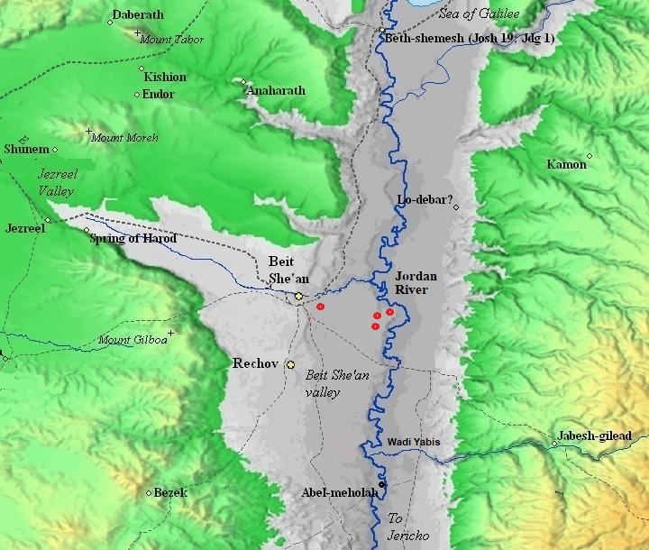
Map of the area of Beit Shean valley – during the Canaanite and Israelite periods (based on Bible Mapper 3.0)
In the antiquity the Jordan river crossings was by crossing fords along the river rather than using bridges or ferries. Bridges were constructed only during the Roman and Mameluke periods. Dorsey (“The roads and Highways of Ancient Israel”) claims that no Bronze or Iron Age bridges were found along the Jordan, and the Bible does not mention such bridges.
David Dorsey (“The roads and Highways of Ancient Israel”, 2018, pp. 104, 114) described 2 Bronze/Iron age roads that connected Rechov, the major city during that time, through a number of Bronze/Iron age sites along these routes. The roads reached two river crossings:
- T7b – from Beit Shean South-South-East to the fords (sites #246 thru 251) – This road passed through the following sites:
- Tel Eshtori (Tell el Maliha) Site #251
- Tell Nimrud (south of kibbutz Maoz Haim) Site #246
- Dabbat el Khurrei (north of Nimrud) Site #247
- Tel Midrash (Tell el Madrasa, east of Mauz Haim) Site #248
- Tel Dubba (Tell edh Dhiyaba, also Tell Abu Khashi), above Makhadat Dhiyaba; Site #249
- A site east of Nimrud; Site #250
- Thru the river crossing fords: Makhadat Sheikh Hussein and Makhadat Dhiyaba
- Later periods
The area was examined in the PEF survey (1866-1877) by Wilson, Conder and Kitchener. A section of their map is shown here, focusing on the western side around Tell el Malhah (Tel Eshtori). The surveyors wrote (Vol 2, p. 27): “Tell el Malhah -An artificial mound, situate close to the spring called ‘Ain el Meiyiteh”.
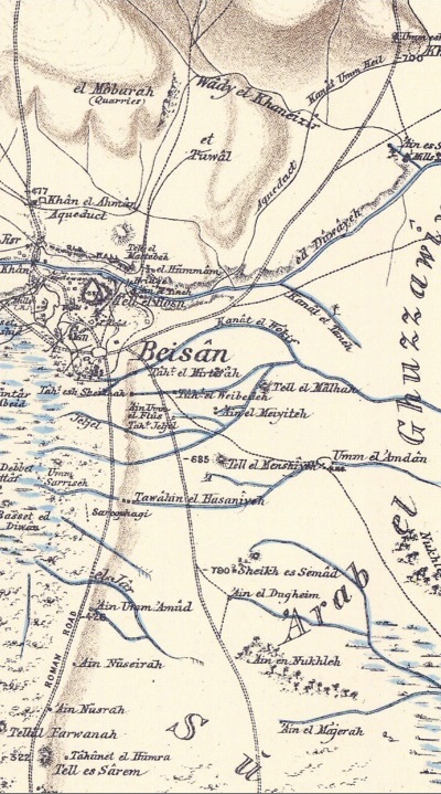
Part of Map sheet 9 of Survey of Western Palestine,
by Conder and Kitchener, 1872-1877.
(Published 1880, reprinted by LifeintheHolyLand.com)
Another section of this map focuses on the western side, with the river crossings of the Jordan river marked as Mak.t. (short for Makhadet – ford). Tell Nimrud is seen on the lower side. The surveyors merely wrote (Vol 2, p. 27): “Tell Nimrud —An artificial mound”.
Part of Map sheet 9 of Survey of Western Palestine,
by Conder and Kitchener, 1872-1877.
(Published 1880, reprinted by LifeintheHolyLand.com)
- British Mandate
A 1940s British map shows the area between Tel Eshtori (here: Tell el Mallia, on the left) amd Sheikh Hussein (on the right). The Jordan river passes on the eastern side of the map, with the bridge of Sheikh Hussein (here: Jisr esh Sheikh Husein) crossing the river. The modern road (highway #71) appears as a red line between Eshtori and the river. Tell Nimrud is on the middle lower side.
British survey map 1942-1948 – https://palopenmaps.org topo maps
License: public domain under the UK Copyright, Designs and Patent Act 1998
-
Modern Times
The sites are in open public areas.
Sites:
A summary of the ancient sites that are reviewed in this page are shown in this table, with indication of the periods that were dated there by the survey of N. Zori (1962).
| # | Site name | Chal- colithic |
Early Bronze |
Middle Bronze I |
Middle Bronze II |
Late Bronze |
Iron Age I |
Iron Age II |
Persian, Hellen. |
Roman, Byzantine |
Early Muslim |
|
| 1 | Eshtori | + | + | + | + | + | + | + | ||||
| 2 | Nimrod | + | + | + | + | + | + | + | + | + | ||
| 3 | Nimrod B | ++ | + | + | + | + | + | |||||
| 4 | Midrash | + | + | ++ | ||||||||
| 5 | Zofim | + | + | + | + | + | + | + | + |
Legend: ++ indicates majority period.
Photos:
(a) Tel Eshtori
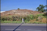
Tel Eshtori (Tell el Maliha or Malhah) is a small mound on the south side of the modern road from Beit Shean to the border pass at Sheikh Hussein. This west-east road was also a central Bronze/Iron trade route to the river crossing fords near Sheikh Hussein.
This view is from the east side. Beit Shean’s industrial area is located on its west and south side.
Click on the photos to view in higher resolution…
A closer view from the east is below. The site is also on the side of another modern road continuing south along the -200m altitude (hence its common name is ‘200m’ road). It passes near Tel Nissa – a large mound 0.5km to the south.
The site is named after Ishtori Haparchi (1280–1355), also Estori Haparchi, pen name of a Jewish physician, geographer, and traveler, Isaac HaCohen Ben Moses. He was expelled from his home in France, and resided in Beit Shean as a physician. His book Kaftor Vaferach gave him the surname Haparchi, while Ish-Tori is based on the phrase Man of Tours (Tours is a city in France).
The mound rises only 7-8m above the ground, and its peak covers a mere 15 x 20m in area. Its small size suggests that this site was a small station along the Bronze/Iron route, probably functioning as a satellite post for Tel Nissa.
On the side of the mound are some large porcupine holes. The mammals dig into the ground, pulling out dirt and pottery fragments, making it easy to sift thru the soil and examine the historic layers.
On and around the mound are evidence of the Iron Age settlement. For example, this smooth flat rock which served as flooring material in the ancient houses.
Sun dried mud bricks are also seen on the mound. These bricks were used for the walls of the houses and the walls surrounding the site.
- Pottery dating:
Ceramics collected on Tel Eshtori were dated by previous survey (N. Zori 1962) to the Early Bronze, Middle Bronze II, Late Bronze, Iron I, Iron II, and Persian.
The following are few samples of interesting findings found during our short survey across the site, which was lead by archaeologist Ayelet Goldberg-Keidar. She also identified the pottery findings in this web page.
- Roman-Byzantine pottery vessel:
- Handle of an Iron Age pottery vessel:
- Pottery segment – probably the front face of a bull (or horse) zoomorphic figurine, dated to the Iron age:
(b) Tel Midrash
Tel Midrash (Tell Madrasah) is a small elongated mound, rising on the east side of the cemetery of Kibbutz Maoz Haim.
The mound is barren and covered with weed most of the year. Its peak covers an area of 40m x 20m.
The mound is surrounded by deep valleys of two streams:
On the north side of the mound is the Madrasah stream, seen in the photo below.
On the south east side of Tel Midrash is the Bala-Menshiyeh stream. It flows from the spring of Tel Nissa, passes near Tel Nimrod, and reaches the Jordan river. The route along the northern bank of Menshiyeh was a convenient way from Beith Shean to the Jordan river.
- Pottery dating:
Ceramics collected on Tel Midrash were dated by previous survey (N. Zori 1962) to the Middle Bronze II, Late Bronze, and the majority were dated to the Iron I period.
During our review of the site we found a piece of a oil lamp, probably dated to the Late Bronze or Iron Age:
An interesting mushroom was also spotted. It had a brown cap and a long dry stick. This mushroom is named “Desert stalked puffball” (Latin: Battarrea stevenii), that grows in dry, sandy locations around the world. It has a woody, slender stem that is typically up to 40 centimeters in length.
The brown cap hides a massive cluster of fungi spoors hidden inside the structures under the cap. When mature, mushrooms release their spores into the air for reproduction.
After shaking the mushroom, millions of spores dispersed into the air as a brown cloud.
(c) Tel Nimrod
Tel Nimrod (Tell Namrud) is located 1km south of Kibbutz Maoz Haim. The mound covers an area of 75m by 50m, rising 3m above the area.
It is seen here from the east side.
The site is on the east bank of Menshiyeh stream (Nahal Eitan), south of its confluence with Nahal Bala stream. The two streams join together, creating a pond near the confluence (now covered by the farming area). During ancient times (also seen on the British map), a ford on its west side permitted the crossing of the Manshiyeh stream, allowing the route from the north west to continue south and east.
The ancient parts of the hill are visible on the center and east side. On the west side are basalt rocks that were brought by the military to create covered bunkers, totally damaging this side of the mound.
- Pottery dating:
Ceramics collected on Tel Nimrod were dated by previous survey (N. Zori 1962) and Ahia Cohen-Tabor (201) to the Early Bronze, Intermediate Bronze/Middle Bronze I, Middle Bronze II, Late Bronze, Iron I period, Iron II, Iron IIc, Persian, Hellenistic, Early/Late Roman, Byzantine and Early Muslim. Few flint stones were also collected.
Yet another site is located 200m north east of Tel Nimrod – named Nimrod B. It is 150 x 100m in area, but was flattened by the farming activity. Most of the pottery is dated to the Middle Bronze II. Other ceramics were dated to Late Bronze or Iron I period, Iron II, Persian, Hellenistic, Roman, Byzantine. Flint and basalt tools were also collected.
Our survey:
During our review of the site, we found the following pottery segments on Tel Nimrod. All items were left on the site.
- Spindle-shaped unguentarium, Hellenistic period. Unguentarium is a small bottle, commonly found in Hellenistic/Roman cemeteries, that was used for perfumes, ointments, and other liquids associated with the toilet. This ceramic bottle is shaped as a spindle – a bulbous bottom and narrow, tubular neck – and lacking a handle.
- Handle of vessel, Bronze/Iron age:
- Handle of vessel, Roman-Byzantine period:
- Part of a vessel, perhaps Late Bronze:
(d) Tel Zofim
Tel Zofim, a site west of Sheikh Hussein, is located on a high steep hill overlooking the Jordan river crossing. Its peak is at altitude -243m (below sea level), 35m above the area below. The Hebrew name means: scouting, and indeed this is a great place to view the area.
In the following photos, the river crossing of Sheikh Hussein is hidden behind the hill. In the far background is Jordan valley and the Jordanian mountains. A modern border station built at this place supports the border crossing of people and commercial goods between Israel and Jordan.
Access to the site is from the south side.
The shape of the hill is like a horseshoe, with an opening towards the east.
Along the southern foothills, seen in the photo below, are visible historical layers and many pottery fragments.
On the summit is an uneven ground, with small heaps of soil, basalt and limestone rocks, and metal poles. Perhaps, traces of modern or ancient structures or tombs.
On the north side of the hill is a steep slope down to the valley of Menshiyeh stream (Nahal Eitan). This is the same stream that passed all the above sites, starting from Tel Nissa.
Many sun dried mud bricks were seen on the summit of mound. These bricks were used for the walls of the houses and the walls surrounding the site.
The orange tan seen on the surface of this brick, as well as others seen on the southern side of the summit, may indicate that the mud brick was subjected to intense fire as a result of conquest. Dr. Yoav Vaknin, a Paleomagnetism expert, confirmed that the sun-dried mud bricks was indeed subjected to heat, and therefore could be used for dating the destruction.
A flat limestone block found on the foothill was probably part of the flooring in one of the rooms. Flat blocks, often made from stone or baked clay, provided a durable and long-lasting flooring option that could withstand the wear and tear of daily activities. These materials were relatively easy to clean and maintain compared to other types of flooring, such as dirt or loose gravel. Stone and baked clay floors offered good insulation properties, helping to keep homes cooler in the summer and warmer in the winter. They also created a uniform and level surface, which was not only functional but also visually appealing.

- Pottery dating:
Ceramics collected on Tel Nimrod were dated by previous survey (N. Zori 1962) to the Early Bronze, Middle Bronze I, Middle Bronze II, Late Bronze, Iron I period, Iron II, Hellenistic, Roman.
During our review of the site, we found the following pottery segments on Tel Zofim. All items were left on the site.
- Bottom of a Biblical period vessel:
- Cooking pot, Iron Age II:
Etymology (behind the name):
- Tel (Tell) – mound (See more on the story of a Tel).
- Makhadet – Arabic: Ford
- Tell el Malhah – the salt mound.
- Tell Nimrud – The mound of Nimrod. He was the son of Cush, a great-grandson of Noah.
- Tel Zofim – Hebrew: mound of scouting.
- Tell Madrassah – Arabic: mound of the Islamic college
- Tel Midrash – Hebrew: mound of the college (based on the Arabic name of the mound – Madrassah). The name may have been based on the nearby Byzantine period Synagogue in Maoz Haim (ancient Bala).
- Tell el-Manshiya (Menshiyeh) – Arabic: the mound of the growth, or: the built mound. The root name is ‘ansha’ meaning: to build. Hebrew name: Tel Nissa (meaning the elevated mound).
Links:
* External, archaeological links:
- British Mandate survey report
- N. Tzori 1962 – Tel Eshtori (Tell el Maliha) – site 85; Tel Nimrod A (Tell Nimrud) – site 79; Tel Nimrod B – Site 80; Tel Midrash (Tell el Madrasa) – 82; Tel Dubah (Tell edh Dhaibeh) – site 50; Tel Zofim, – (site west of Tell edh Dhiabeh) – site 51.
- Survey of Tel Rechov area – Ahia Cohen-Tavor , 2010, Hebrew Univ, Hebrew; Site 92: Tell Nimrod
* Other external links:
* Other River Crossing sites:
* Internal links:
- Jordan valley sites map
- Mud Bricks – Overview of sun-dried mud bricks used in ancient sites.
BibleWalks.com – exploring the ancient sites of Israel
Tels Zemed, Saharon, Malluah<<<—previous Jordan Valley site—<<< All Sites>>> — Next site—>>>Horvat Baat
This page was last updated on June 10, 2024 (add note on burnt mud brick)
Sponsored links: