Tel Tsaf and Tel Gamma – ancient sites near the Jordan river.
Home > Sites > Jordan Valley > Tel Tsaf and Tel Gamma
Contents:
Background
Location
History
Identification
Photos
* Tel Tsaf
* Tel Gamma
Etymology
Links
Background:
This page reviews Tel Tsaf (a large Late Neolithic site) and adjacent Tel Gamma (a Chalcolithic to Israelite period site) – two archaeological sites located near ancient crossings of the Jordan River in what is now modern-day Israel. These sites have provided valuable insights into the prehistoric and ancient history of the region.
Location:
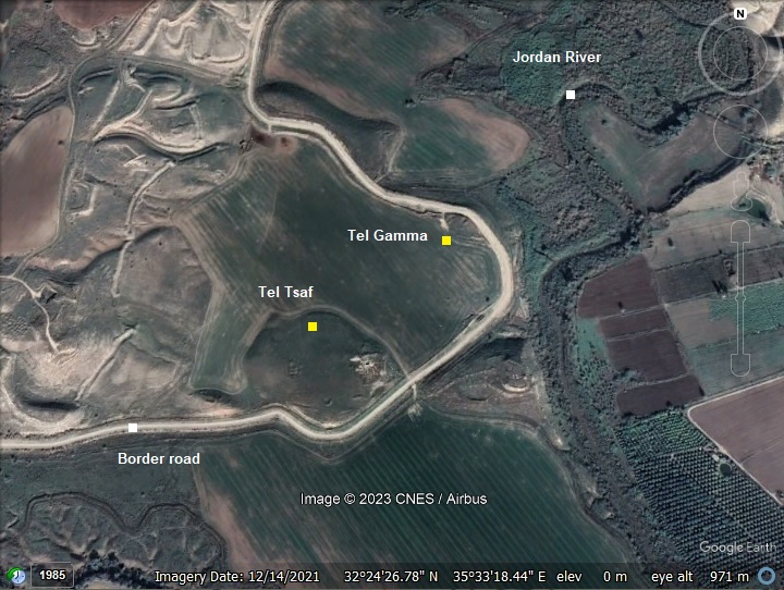
Tel Tsaf and adjacent Tel Gamma are located near the ancient river crossings thru the fords along the Jordan river. During ancient times the Jordan River was crossed at selected fords rather than bridges. These sites are adjacent to one of the crossing points in the southern Beit Shean valley.
Both Tels are at 278m below sea level – rising 25m above the river. They lie right at the edge of the west bank of the Jordan river, at the edge of the upper (Ghor) terrace and above the lower (Zor) floor.
History:
- Neolithic period (8,300 -4,500 BC)
On Tel Tsaf (Tell es-Sufuh) are ruins of a large Neolithic (New stone Age) period settlement, situated above the west bank of the Jordan river. The site consists of three low hills and covers a total area of 50 dunams The remains are found just below the surface and in the fields around it.
The archaeologists dated the settlement to 5200-4600 BC – an early stage of the common term of Chalcolithic period. The settlement consisted of courtyard buildings with rectilinear rooms (with straight, right-angled corners), rounded rooms and 19 silos for storing grains. It was advanced compared to other Pottery-Neolithic settlements – as attested by the large grain silos, the building structures, the discovery of a large quantity of olive pits, finding of unique vessels and imported goods from remote countries.
- Chalcolithic period (4,500 – 3,150BC)
Another section of the settlement was established on Tel Gamma (Tell el Jama’in) , a low and small hill 150m north east to Tsaf.
- Bronze and Iron age periods (3,150-1,200; 1,200-586 BC)
Only Tel Gamma continued to be settled during these periods. The settlement reached a peak during the Iron Age II but was destroyed during the 9th century BC.
-
Biblical map
The cities and roads during the Bronze/Canaanite and Iron/Israelite periods are indicated on the Biblical Map below, with the location of Tel Tsaf and Gamma are marked by a red dot on the west bank of the Jordan river. The location of another site – Tell Abu Sus – 3km south, is labeled as “Abel-Meholah” – one the Biblical identifications of the ancient city. The major sites in the area include Rechov (the major Iron Age II city) and Beit Shean.
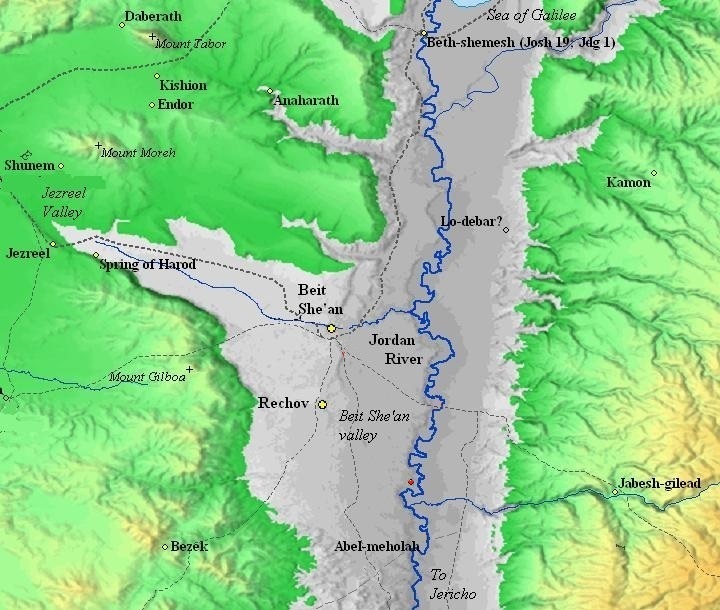
Map of the area of Beit Shean valley – during the Canaanite and Israelite periods (based on Bible Mapper 3.0)
- Jordan river crossing
In the antiquities the Jordan river crossings was by crossing fords along the river rather than using bridges or ferries. Bridges were constructed only during the Roman and Mameluke periods. Dorsey (“The roads and Highways of Ancient Israel”) claims that no Bronze or Iron Age bridges were found along the Jordan, and the Bible does not mention such bridges.
South of Tel Tsaf and Tel Gamma is the valley of Nahal Qaun. It makes sense that the crossing of the Jordan river was to the north of the Qaun delta in order to avoid yet another muddy crossing. David Dorsey (“The roads and Highways of Ancient Israel”, 2018, pp. 104, 114, 172-173) listed 2 Bronze/Iron age roads that came through the sites to the river crossing north of Nahal Qaun:
- T9a – from Rehov to Tel Abu Sus (sites #272 thru 277) – This road connected Rehov, the most important city in the area, through the following sites: Tellul eth Thaum (Tel Teommim), Tel ‘Alya, Tell er Ridhghah (Tel Shalem), Tel Muleiqat then crossing the Jordan river.
- S13 east – from Qa’un and Tel Malqoah – This road, branching off from the main ancient highway “A3” (Beit Shean-Rehob-Jericho), joined T9a to cross the Jordan river.
There are other river crossing north and south of these sites: Kfar Ruppin area (10 sites west of the Jordan river) and Tel Abu Sus and Sakut.
On the other side of the Jordan river are a number of Bronze/Iron Tels that mark the continuation of the route in Jordan. The road then ascended up the Jordanian mountains along Wadi al-Yabis. The trans Jordan mounds include: Tel Mij’ama, Tel Sharhabil, Tel Abu Kharaz. The latter, Tel Abu Kharaz, is identified by some scholars as the Biblical city of Jabesh Gilead, an ancient Biblical city mentioned in the Old Testament of the Bible. It was situated in the region of Gilead, which was located east of the Jordan River and was known for its rugged terrain. Here are some key points about Jabesh Gilead:
- Jabesh Gilead is mentioned several times in the Old Testament, notably in the Book of Judges and the First Book of Samuel.
- One of the most well-known events associated with Jabesh Gilead is its rescue by the Israelites. In the Book of Judges (Judges 21:8-15), the city faced a dire situation when its inhabitants were under threat from neighboring tribes. The rest of the Israelite tribes came to their aid, and this event played a role in uniting the tribes of Israel.
- In the First Book of Samuel (1 Samuel 11), Jabesh Gilead is mentioned in the context of King Saul’s early reign. When the Ammonites threatened the city and its inhabitants, Saul responded by leading an army to rescue them. This victory helped solidify Saul’s kingship.
- There is also a tragic event associated with Jabesh Gilead in 1 Samuel 31. After Saul’s death on Mount Gilboa, the Philistines captured his body and the bodies of his sons. The bodies were hung on the wall of Beth-shan, but brave men from Jabesh Gilead undertook a daring mission to recover the bodies and give them a proper burial.
- The city of Jabesh Gilead played a significant role in the early history of the Israelite monarchy.
- Roman/Byzantine periods
During these periods, the major settlement moved to nearby Tel Shalem (Tell er Ridhghah), close to Ein Avraham spring (‘Ain er Ridhghah). A Roman military camp was constructed on its south side. The imperial road from Beit-Shean to Jericho passed on its west side.
-
Later periods
The site was examined in the PEF survey (1866-1877) by Wilson, Conder and Kitchener. A section of their map is shown here. They did not mark Tel Tsaf nor Tel Gamma. These two sites are located in the open area in the middle of this section, west of the Jordan river.
A river crossing (marked as Mak.t – short for Makhadet – Arabic for ‘ford’) appears as a short lines north of Tel Gamma. An ancient road, marked by a dashed line that followed the edge of the cliffs, crossed the river at that point (Makhadet Abu Naj).
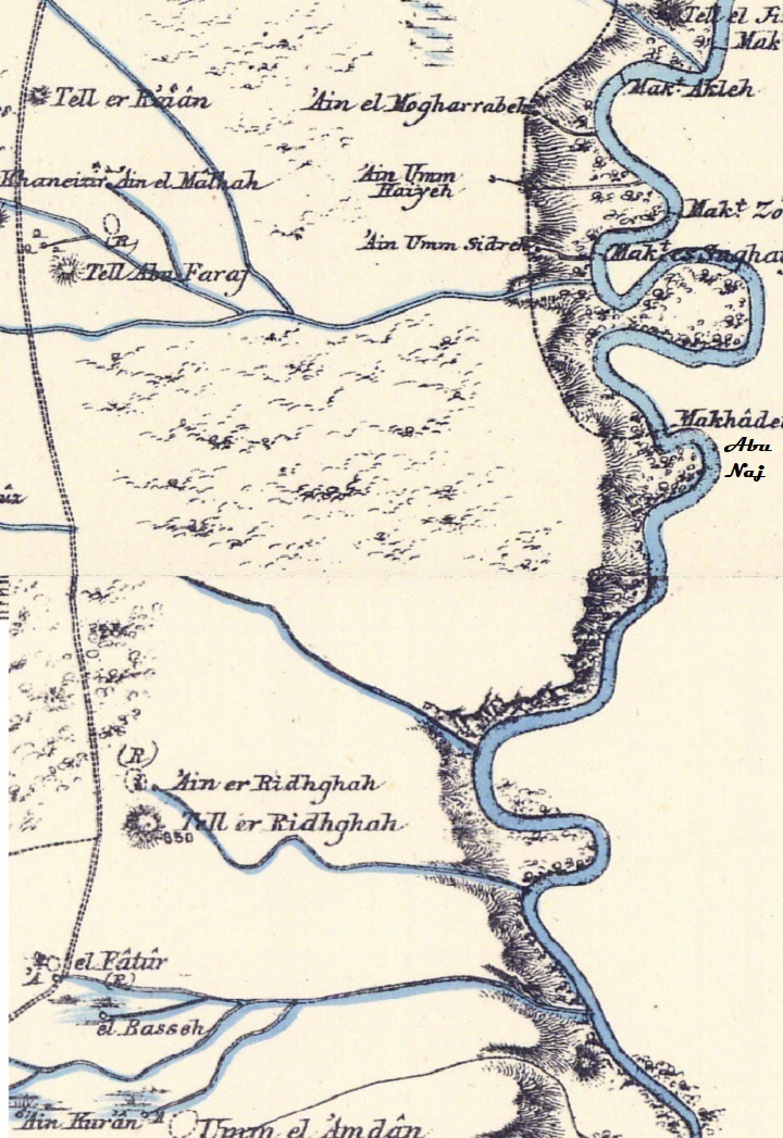
Part of Map sheet 12 of Survey of Western Palestine,
by Conder and Kitchener, 1872-1877.
(Published 1880, reprinted by LifeintheHolyLand.com)
- British Mandate
A 1940s British map shows the area around the site with more details. The two sites are not marked here but are located in the center of the map, north east of the mouth of the stream named Khor es Sufuh, within the area between the loop of the Jordan river. The mouth of Nahal Bezek (Wadi Shubash) is just north of the sites. The soil it brought downstream from the Gilboa mountain range caused the Jordan river to be pushed to the east, thus creating the loop and the landscape.
Across the river is Tell el Mi’jama – a Biblical site along the river crossing route. Nelson Glick dated the ceramics on that site to Late Bronze (few), and Iron Age I and II (major period). Many flint tools were also found.
British survey map 1942-1948 – https://palopenmaps.org topo maps
License: public domain under the UK Copyright, Designs and Patent Act 1998
-
Modern Times
The two sites, Tsaf and Gamma, were discovered in the 1950s by N. Zori. They were later damaged by the military border road along the west bank of the Jordan river.
A test excavation of Tel Tsaf was conducted in 1980 by Ram Gofna. It was followed by a large excavation project that was conducted by Yosef Garfinkel (Hebrew University, Jerusalem) in 2004–2007 . Renewed excavations in 2013-2021 were conducted by the Zinman institute of archaeology (Haifa University), headed by Danny Rosenberg.
Tel Tsaf is accessible by a dirt road from kibbutz Tirat Zvi. However, due to its location on the side of the border road, this access is limited to off-road vehicles. Tel Gamma was cut to half by the border road, and is not easily accessible.
Photos:
(a) Tel Tsaf (Tell es-Zaf)
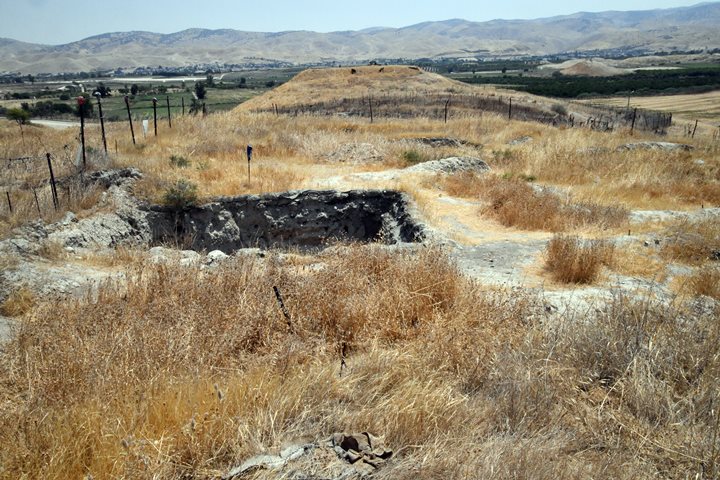
Tel Tsaf is a large Late Neolithic site, dating back to around 5,500 to 4,500 BCE, making it over 7,000 years old. It sheds light on the transition from a society of hunter-gatherers to settled agricultural communities. Archaeological excavations at Tel Tsaf have uncovered evidence of early farming, pottery production, and complex social structures. Some of the notable findings at Tel Tsaf include pottery vessels, tools, and architectural remains – buildings and silos.
The site spreads on three low hills above the west bank of the Jordan river. On the site are ruins of a large Pottery Neolithic period settlement, covering an area of 50 dunams.
This view of the site is from the north east side.
Click on the photos to view in higher resolution…
- East side (2004-2007 seasons):
Several squares were opened on the east side during the 2004-2007 seasons headed by Garfinkel. This is a view towards the south east.
Except for the archaeological areas that were cut just below the surface, there are no architectural elements visible. The depth of the squares is shallow, since the occupational remains begin right below the surface.
Next – a view towards east.
Buildings: A closer view of a rectangular room inside a courtyard in one of the buildings is below. The walls are built of sun dried mud bricks. A line of the bricks can be seen in the back wall. The walls were coated with plaster, and the structure had a beaten earth floor.
Silos:
The archaeologists unearthed 19 round silos that stored grain for commercial purposes. The silos were dated to the the late 6th Millennium BC. They were unique at their time as the silos were built above the ground, carefully built, had larger storage capacity, and were built in the center of the settlement within nuclear-family courtyards.
Their structure was cylindrical, barrel-shaped structures, with outer diameters between 2 to 4m. The silos were built in groups within the courtyards of four buildings, and arranged in straight lines.
The thick base of the silo was paved with several layers of bricks, with a lime plaster sealing the inside, built to protect the grain from rodents and humidity. Above the podium were thin mud brick walls, plastered on the outside, and reaching an estimated 2m height. The walls and roof did not survive. The archaeologists suggested that the roofing was made of wood reeds and mud.
Four burial places and figurines were found adjacent to the silos, indicating the symbolic and religious significance of the silos. A unique vessel was also found in the shape of a silo, attesting to a grain storage ritual.
- South West side (2022 season):
This area is on the south west side, where the renewed excavations in 2022 were conducted, headed by Danny Rosenberg. Several shallow squares were opened here.
The structures were built with sun dried mud bricks. This is one of the bricks we saw on the ground.
The excavation team also researched the method of producing the mud bricks. In an area close to the excavation squares they performed experiments.
Next – a view towards the south. The border road and fence are seen just below the eastern foothills.
Pottery dating:
In 1962 N. Zori dated the ceramics and flint to the Chalcolithic period. New excavations that followed his report also date the settlement to earlier dates (5200-4600 BC).
Findings:
In our short survey, we found the following objects: (All items were left on site)
- Part of a Neolithic vessel
2. A handle of a Biblical period vessel

3. Part of an undated vessel
4. Flint stone tool
(b) Tel Gamma
Tel Gamma (Tell Jamma’in) is a smaller elongated hill, a northern extension of Tel Tsaf. It covers an area of 50 x 70m. A spring (Ain Jamma’in) flows on its eastern foothills.
This unexcavated archaeological mound spans a longer period – starting from the Chalcolithic period to the Early Muslim period, making it a site of continuous occupation for thousands of years.
In this photo the site is seen in the center, cut on its north and east sides.
The site was damaged by the border road that cut its sides.
A view from the side of the road shows the layers of the mound, with accumulated layers – result of historical settlement activities.
Below – a closer view of the cut on the north east side of the mound. A destruction level can be seen just below the surface, at the line of pottery fragments and flooring stones.
Pottery dating:
According to N. Zori (1962), the ceramics were dated to the Neolithic period (few), Chalcolithic, Early Bronze, Middle Bronze II, Late Bronze, Iron Age I, Iron II (Majority), Persian, Byzantine, and Early Muslim.
On the low hills 100m west of the site Zori also dated the pottery fragments and flint tools to the Chalcolithic period.
Findings:
During our short survey, limited by the proximity of the site to the border, we found the following items on the eastern cut of the hill:
5. Hippo storage jar
On the east side of the mound we noticed a large pottery fragments of the same vessel. This piece, was identified as a ‘Hippo’ type storage jar. Due to the large swollen bodies of such jars, they are dubbed ‘Hippo’ jars. The average sizes in these group of Iron age jars contained 52 liters, had a height of 58 cm, a body diameter of 42 cm, and neck diameter of 10cm (as per Karasik et al article).
In the photo below – a bottom piece of the vessel.
According to archaeologist Ayelet Keidar-Goldberg, who headed the survey, this jar can be compared to an item in the Tel Rechov pottery table of the Iron Age II stratum IV, where it was dated to the early 9th century BC. It may have been manufactured in the pottery workshops of Tel Rechov – the major city in the area. Based on this dating, we may conclude that this destruction layer was the result of the conquest by Hazael of Aram-Damascus.
A closer detail of the handle of the Hippo storage jar is in the next photo. Notice the potter’s mark on the handle – a common feature of Iron Age II pottery. It is in the shape of a letter ‘V’.
Similar potter’s mark were discovered on Hippo jars in the excavations of Tel Rechov (e.g., stratum C-1a 13.139:51 and E-1a 18.11:1). Both examples are Late Iron IIa vessels (general stratum IV), with destruction on early 9th century BC (840/830 BC).
Some jars had an inscription on the side of the vessel.
Although the site was heavily damaged, it deserves further research.
Etymology (behind the name):
- Tel (Tell) – mound (See more on the story of a Tel).
- Makhadet – Arabic: Ford
- Tell es-Sufuh – previous name of Tel Tsaf, named by N. Zori based on the name of the nearby stream Khor es Sufuh (Arabic)
- Khor – translated to English: “inlet” or “bay,”
- Sufouh – Translated to English: “outskirts”
- Tell a-Zaf – another Arabic name of the site; Zaf – joyful.
- Tel Tsaf – Hebrew name of the site (צף is floating in Hebrew, sounding like the Arabic name)
- Tell Jamma’in – Arabic name of the mound. Means “group”, named after the group of hills.
- Tel Gamma – Hebrew name of the site, preserving the Arabic name.
- Tirat Zvi – Hebrew: Zvi’s fort. Tirat Zvi, a religious Kibbutz established in 1937, was named after Rabbi Zvi Hirsch Kalisher – A religious Zionist forerunner.
Links:
* Tel Tsaf:
- Tel Tsaf – research project
- N. Tzori 1962 – Tel a-zaf (Tsaf) – site 64
- Large-scale storage of grain surplus in the sixth millennium BC: the silos of Tel Tsaf – Yosef Garfinkel, David Ben-Shlomo & Tali Kuperman – 2009 Ant 83 (pp 309-325)
- Large-scale storage and storage symbolism in the ancient Near East: a clay silo model from Tel Tsaf – Danny Rosenberg, Yosef Garfinkel, Florian Klimscha – CUP 2017
- 7,200 years old constructions and mudbrick technology: The evidence from Tel Tsaf – Rosenberg, D., Love, S., Hubbard, E., and Klimscha, F; 2020
- Excavation at Tel Tsaf: an Early Chalcolithic site in the Jordan Valley. Tel Aviv 15-16: 3–36. Gophna R. and Sadeh S. 1988-1989
- The Beginning of Metallurgy in the Southern Levant: A Late 6th Millennium CalBC Copper Awl from Tel Tsaf, Israel – Yosef Garfinkel, Florian Klimscha, Sariel Shalev, Danny Rosenberg; 2014
-
Tel Tsaf – Preliminary Report; Danny Rosenberg, Sonia Pinsky and Florian Klimscha HS-Esi 133 2021
* Tel Gamma:
- N. Tzori 1962 – Tel Jama’in (Gamma) – Site 63
- Hippo Jars origins confirmed – Jpost article, 2014
- The Morphology of Iron Age Storage Jars and Its Relation to the Handbreadth Measure – on Iron Age storage jars; Karasik et al (BASOR 384, 2020)
* General links:
- Tzori N. 1958. Neolithic and Chalcolithic sites in the Valley of Beth-Shean. Palestine Exploration Quarterly 90: 44–51.
- Survey of Tel Rechov area – Ahia Cohen-Tavor , 2010, Hebrew Univ, Hebrew (sites 110-111)
* Other River Crossing sites:
* Internal links:
- Map of Jordan valley sites
- Mud Bricks – Overview of sun-dried mud bricks used in ancient sites.
BibleWalks.com – exploring the ancient sites of Israel
Horvat Menorah<<<—previous Jordan Valley site—<<< All Sites>>> — Next site—>>>Tel Zemed
This page was last updated on Oct 2, 2023 (misc update)
Sponsored links: