Two Bronze/Iron age sites in the Jordan valley, on the route from Rechov to the Jordan river crossings.
Home > Sites > Jordan Valley > Tel Malqet and Tel Ro’eh
Contents:
Background
Location
History
Identification
Photos
* Tel Malqet
* Tel Roeh
Etymology
Links
Background:
Tel Malqet (Tell Molikat) is a small Bronze/Iron age site in the Jordan valley, south of Kibbutz Tirat Zvi.
Tel Ro’eh (Tell er Ra’yan ) is another multi-period site, north of Tirat Zvi.
These Biblical mounds were on the route (“T9a, T9b”) from Rechov to the Jordan river crossing.
Location:
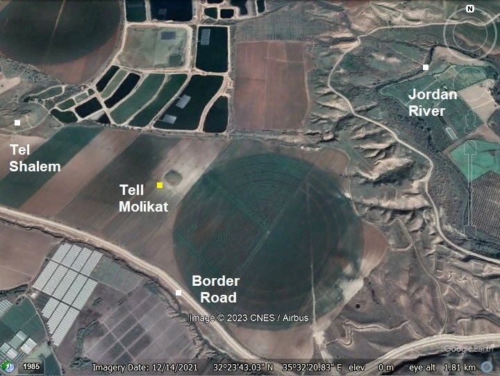
Tel Malqet (Tell Molikat) is located 3km south-south-east of Kibbutz Tirat Zvi, 1km south east of Tel Shalem (Tell el-Ridhghah), and 1.5 km west of the Jordan river. It is a low hill, only 5m above the farming area that surrounds it.
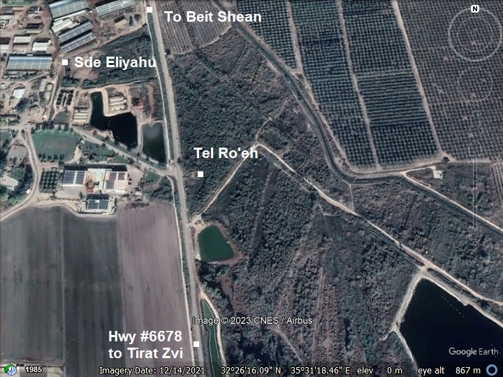
Tel Ro’eh (Tell er Ra’yan) is adjacent to Kibbutz Sde Eliyahu, 2 km north of Kibbutz Tirat Zvi. This small mound was damaged on the west side by the modern road and drainage canal, and parts of it are covered by bush.
History:
- Bronze and Iron periods (3,150-1,200 BC, 1,200-586 BC)
The main settlement periods of these sites were during the Bronze and Iron Age periods.
-
Biblical map
The cities and roads during the Canaanite and Israelite periods are indicated on the Biblical Map below, focusing on the area of the valley Beit Shean – a northern section along the Jordan valley.
Tel Malqet (Tell Molikat) is indicated as a red dot. It faces Wadi Yabis on the other side of the Jordan river. The ancient route to Jabesh Gilead passed along this valley. The ancient route also continued south, reaching a major river crossing point (near Tel Abu Sus) marked by “Abel-Meholah” on the west bank of the Jordan river.
Tel Ro’eh (Tell er Ra’yan) is indicated as an orange dot. It is located north to Malqet, situated along another route to the Jordan river, with a crossing point of Tel Gamma via the Abu Naj ford.
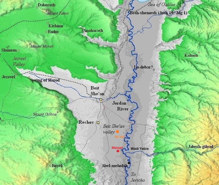
Map of the area of Beit Shean valley – during the Canaanite and Israelite periods (based on Bible Mapper 3.0)
In the antiquity the Jordan river crossings was by crossing fords along the river rather than using bridges or ferries. Bridges were constructed only during the Roman and Mameluke periods. Dorsey (“The roads and Highways of Ancient Israel”) claims that no Bronze or Iron Age bridges were found along the Jordan, and the Bible does not mention such bridges.
Tel Malqet (Tell Molikat) and Tel Ro’eh (Tell er Ra’yan) were founded as cities along the ancient routes that crossed the river towards the east.
David Dorsey (“The roads and Highways of Ancient Israel”, 2018, pp. 104, 114) described 2 Bronze/Iron age roads that connected Rechov, the major city during that time, through a number of Bronze/Iron age sites along these routes. The roads reached two river crossings:
- T9b – from Rehov to Tel Abu Sus (sites #272 thru 277) – This road connected Rehov, the most important city in the area, through the following sites:
- Tellul eth Thaum – Tel Teomim (#272)
- Sde Terumot site (#273)
- Tel ‘Alya – adjacent to Tel Shalem on the north side (#274)
- Tell er Ridhghah (Tel Shalem) (#275)
- Tell Molikat (#276)
- Kh. Khisas ed Deir (#277)
- to the river crossings near Tell Abu Sus.
- T9a – from Rehov to Tel Gamma (sites #268 thru 271) – This road connected Rehov, the most important city in the area, through the following sites:
The major settlement period on Tel Malqet (Tell Molikat) was in the Middle Bronze II period. The nearby Tel Shalem (Tell er Ridhghah) was the major settlement in this area, established during the Early Bronze period and continued to the Middle ages.
The settlement periods on Tel Ro’eh were the Middle Bronze, Late Bronze and Iron Ages.
- Late Roman/Byzantine period
An imperial Roman road, from Beit Shean to Jericho, passed to the west of these two sites. It appears on the Ottoman period map seen below.
In 1952 a Roman milestone was found in Sde Eliyahu. It dates to 213 AD, during the reign of emperor Marcus Aurelius Antoninus (aka Caracalla), 198-217 AD. The milestone stood on the 5th mile from Beit Shean to Jericho.
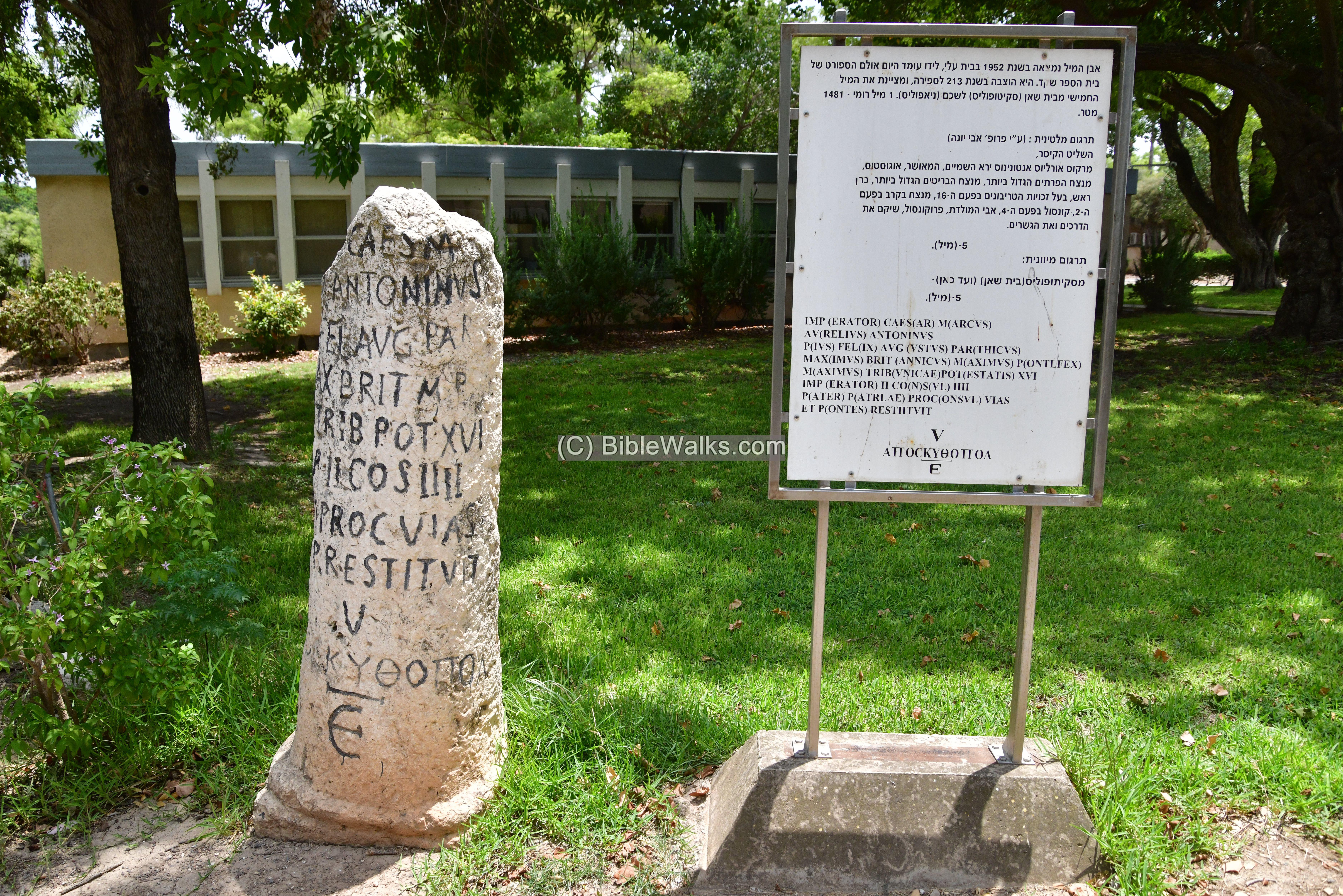
In nearby Kibbutz Tirat Zvi there are additional milestones on display, belonging to the 6th and 7th mile of this important road
-
Ottoman period
Tel Malqet (Tell Molikat) was examined in the PEF survey (1866-1877) by Wilson, Conder and Kitchener. A section of their map is shown here, with Tell Mollikat indicated as a red dot. It is not marked on the map nor in their report. An ancient road connected the site to the Jordan river. The river crossings (marked as Mak.t – short for Makhadet – Arabic for ‘ford’) appear as a short lines north and south north and south of Tell Abu Sus, south of Tell Mollikat.
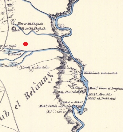
Part of Map sheet 12 of Survey of Western Palestine,
by Conder and Kitchener, 1872-1877.
(Published 1880, reprinted by LifeintheHolyLand.com)
Tel Ro’eh (here: Tell er Raian -“The mound of the shepherds”) is seen on another section of their map. The PEF survey wrote (Volume 2, p. 127): “Tell er Raian – An artificial mound; a spring (‘Ain es Sufsafeh) exists on the north, and water from the ‘Ain el Malhah on the south”.
A north-south Roman road is marked on the side of the site, connecting Beit Shean to Jericho along the west bank of the Jordan river. In the modern times the northern section of this route is now paved as highway #6678, from Beit Shean, but stops at Tirat Zvi. In Bronze/Iron Ages a section of this road was marked by Dorsey as ‘T9a’ – from Rehov (from North west of Tel Ro’eh) to the river crossing at Tel Gamma thru the Abu Naj ford.
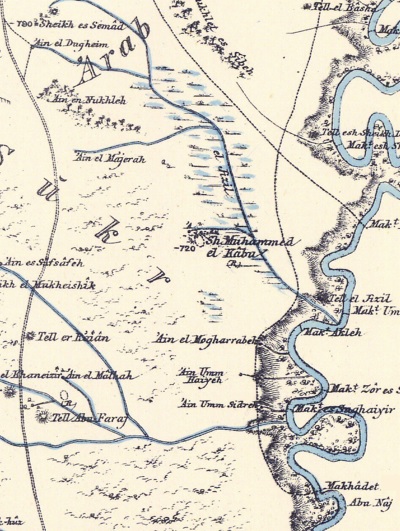
Part of Map sheet 9 of Survey of Western Palestine,
by Conder and Kitchener, 1872-1877.
(Published 1880, reprinted by LifeintheHolyLand.com)
- British Mandate
A 1940s British map shows the area around Tel Malqet (Tell Molikat) with more details. The site is marked here as “Tell Muleiqit”. The Jordan river passes on the eastern side of the map.
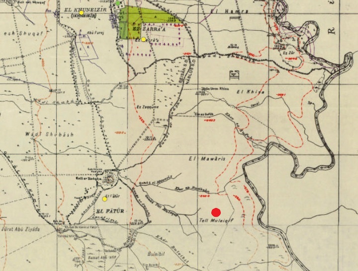
British survey map 1942-1948 – https://palopenmaps.org topo maps
License: public domain under the UK Copyright, Designs and Patent Act 1998
Tel Ro’eh (here: Tell er Ru’yan) is marked on another section of the British map, adjacent to the road. It is shown cut by the road on its western side. On the west and south sides of the Tel are a number of springs (marked “Sps”).
British survey map 1942-1948 – https://palopenmaps.org topo maps
License: public domain under the UK Copyright, Designs and Patent Act 1998
-
Modern Times
Tel Malqet (Tell Molikat) is in the middle of a farming land, and can be accessed by a dirt road from Tirat Zvi.
Tel Ro’eh (Tell er Ra’yan) is in a public nature reserve park facing Kibbutz Sde Eliyahu on the other side of the road.
Photos:
(a) Tel Malqet (Tell Molikat)
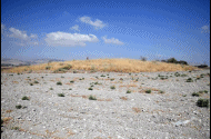
Ruins of Tel Malqet (Tell Mollikat) are spread on a low hill and on the area east and south of the hill. The hill covers an area of 2.5 dunams, and the pottery fragments cover an area of 8.5 dunams.
Click on the photos to view in higher resolution…
The top of the hill was covered by low weed during our visit on August 2022. The heat in this area is scorching, as this location is 225m under sea level, in one of the hottest areas in the region.
Below – a view towards the north west. The mound seen in the center is Tel Shalem (Tell er Ridhghah). It was populated in the Early Bronze, Middle Bronze II, Late Bronze, Iron Age II, Persian and Hellenistic,Byzantine, Early Muslim (many) and Mameluke periods. To its south (left side) was a large Roman military camp.
On the hill are deep holes that were dug in by porcupines. The mammals dig into the ground, pulling out dirt and pottery fragments, making it easy to sift thru the soil and pick up the ceramics.
- Ceramics:
Ceramics collected on the mound and on its foothills were dated by the Manasseh Hill Country survey (2005) to the Middle Bronze II (100%). N. Zori dated the ceramics to additional periods: Persian, Byzantine and Early Islam. The majority are spread on the east side. Flintstones were dated to the Mesolithic and Bronze age.
In our short visit to the site, we have collected the following samples from the porcupine holes (and leaving them on the site). Almost all the pottery was date to the Middle Bronze II period.
Here are some of the items from closer views:
1. Middle Bronze bowl?
2. Another view of this bowl:
3. Middle Bronze?
4. A thumb-indented ledge handle (Hebrew: ידית מדף בהונה). It is dated to the Intermediate Bronze period or Middle Bronze I:
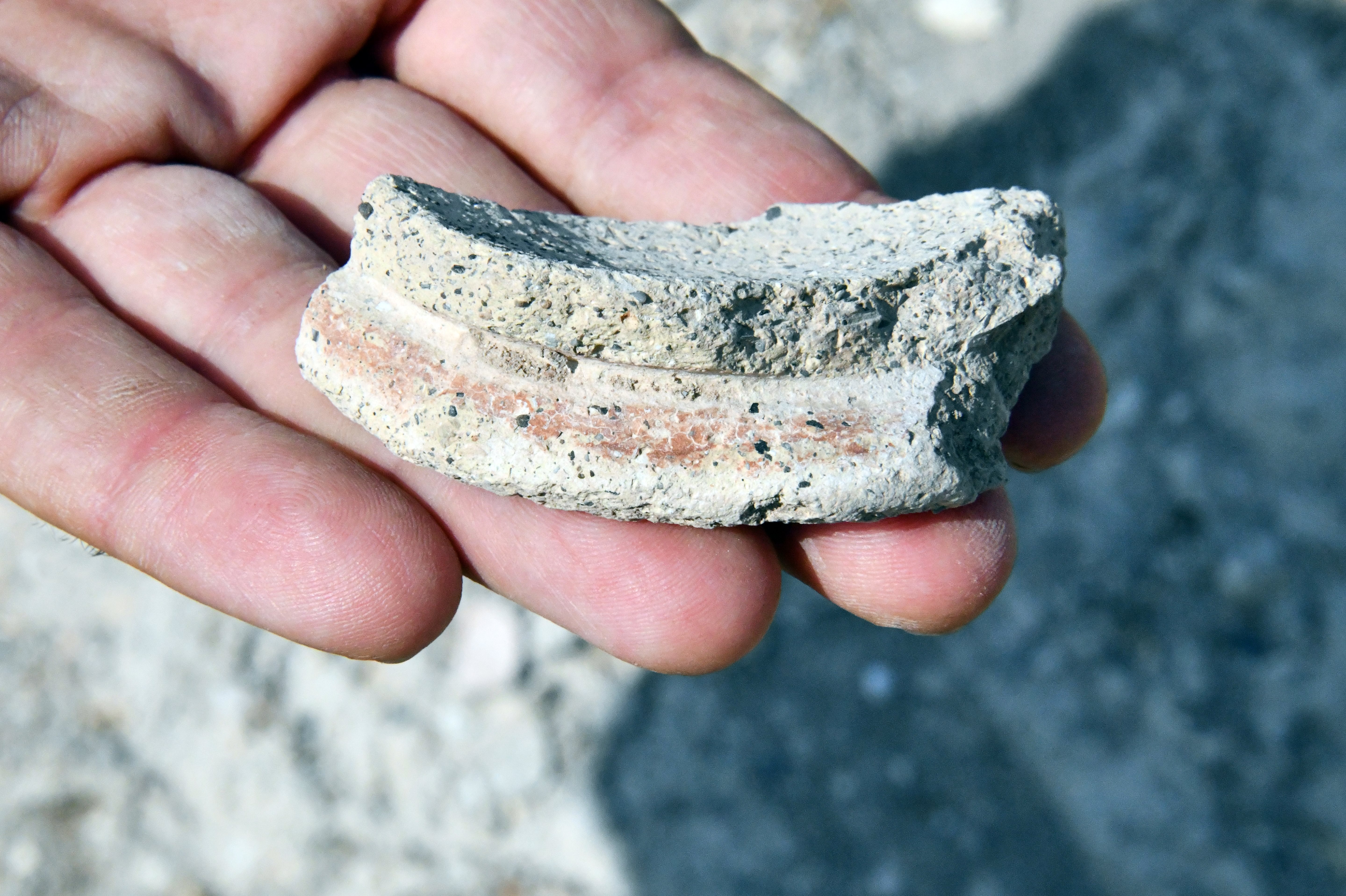
5. Vessel dated to the Middle Bronze period (although initially it seemed an Iron Age period pottery)
-
Other findings:
A section of a sun-dried mud brick. These bricks were used for erecting the walls and the houses during the Bronze and Iron Age. Most of the bricks have since crumbled, or buried in the ground.
Also seen in our second visit to the site: Two bases of grinding stones, dated to the Bronze age:
-
Knuckle Bones:
An interesting bone was found during our short visit – a Knucklebone used to play during the antiquities.
Knick-knack, also known as knucklebones or as astragalus, is an ancient dice game that was played with animal bones. The game involves throwing four small bones (typically from the ankle of a sheep or goat) and trying to score points based on how they land. The bones have different sides, each with a different value.
The basic rules of knick-knack involve throwing the bones in the air and trying to catch them on the back of your hand. Depending on how the bones land, you can score different points. For example, if all four bones land on their flat side, it is called a ‘fourer’ and is worth the most points. If one bone lands on its flat side and the others on their curved sides, it is called a ‘pounder’ and is worth fewer points.
Knick-knack has been played for thousands of years and was popular in many different cultures, including ancient Greece, Rome, and Egypt. It was also played by Native American tribes and is still played in some parts of the world today. These game bones are found in many ancient sites in Israel.
Below – the bone after cleaning the dust with water.

(b) Tel Ro’eh
Tel Ro’eh (Tell er Ra’yan ) is another small (2.5 dunam) multi-period site, east of Kibbutz Sde Eliyahu and north of Tirat Zvi. This Biblical mound was situated on the side of an ancient route from Rechov to the Jordan river crossing at Tel Gamma thru the Abu Faraj ford.
The site was damaged by the modern road at the entrance to Kibbutz Sde Eliyahu. Its western side was removed, and a cross section is exposed along the modern road. The drainage canals also added damages to the western side.
There are several springs on the west and south side of Tel Ro’eh, and large fish ponds that surround the site. The level of the water in the area limited the archaeologist N. Zori during his limited excavations in 1956, as he could not dig lower than 6.5m and did not reach bedrock.
The area of the summit is 25 x 25m, rising 5m above the road. On the top of the site is an observation gazebo, as part of Tel Roeh archaeological promenade. It was donated by Kibbutz Sde Eliyahu.
In front of the gazebo is a large rock, perhaps it belongs to the ancient site.. Its purpose during antiquity may have been special, but is not known to us.
The archaeologist identified 6 settlement layers: VI – Middle Bronze II, V – Late Bronze I, IV-III Late Bronze II, II – Iron Age I, I – Iron Age II,
In the MBII layer (VI ) they found 2 Egyptian scarabs of the 19th dynasty, one of them Ramses II. In the Iron Age I layer (II) they exposed structures made of mud bricks, clay ovens lined with pottery, and a wine press installation.
Remains of a base of the Iron Age settlement (?) are exposed near the gazebo.
- Ceramics:
N. Zori dated the pottery to the following periods: Early Bronze, Middle Bronze I (few), Middle Bronze II, Late Bronze (the majority), Iron Age I, Iron Age II, Persian, Mameluke.
In our short visit to the site, we have collected the following samples (and leaving them on the site).
4. Handle of a Jar with finger-print (Iron Age I):
5. Late Bronze or Iron Age:
Etymology (behind the name):
- Tel (Tell) – mound (See more on the story of a Tel).
- Makhadet – Arabic: Ford
- Tell er Raian – Arabic: “The mound of the shepherds”. (PEF dictionary)
- Tel Ro’eh – Hebrew name – translation of the Arabic name
- Tell Molikat – Arabic name
- Tel Malqet – Hebrew name, based etymologically on the Arabic name
- Sde Eliyahu – Religious Kibbutz; founded in 1939; named after Rabbi Eliyahu Guttmacher (1795–1874)
Links:
* External, archaeological links:
- “The Manasseh hill country survey” Volume 4 [Adam Zertal , ISBN 965-311-012-8, 1996, p.147, Hebrew]
- Site 19: Tell Molikat
- N. Tzori 1962 – Site 65 (Tell el Mollikat), site 73 (Tel Ro’eh)
- Bergman & Brandsteter Arch. surveys in Beit She’an valley (1940-1941:86-90, Hebrew)
- Survey of Tel Rechov area – Ahia Cohen-Tavor , 2010, Hebrew Univ, Hebrew; Site 63 (Ro’e), Site 107 (T. Malqet)
* Other River Crossing sites:
* Other Links:
- Ancient Games in Israel
- Mud Bricks – Overview of sun-dried mud bricks used in ancient sites.
- Tel Shalem – nearby site
- Jordan Valley Sites map
BibleWalks.com – exploring the ancient sites of Israel
Tels Zemed, Saharon, Malluah<<<—previous Jordan Valley site—<<< All Sites>>> — Next site—>>>
This page was last updated on Sep 15, 2024 (new Molikat pottery)
Sponsored links: