This web page lists a set of maps of the sites that are featured in BibleWalks.com. Additional maps include maps of the Bible, the history and the Holy Land. A list of useful links are provided as well.
Overview:
This page lists a set of useful maps that are featured in BibleWalks or in external web sites.
Contents:
(1) Regional sites maps:
Since there are hundreds of Biblical sites, we grouped the sites according to their geographical region to a total of 18 areas. For these regions we have a local map, based on Google maps, that combine satellite imagery and interactive controls. Use the maps to navigate to the selected featured sites in BibleWalks.com. The areas are listed in an order from north to south.
- Golan maps
- Upper Galilee sites
- Sea of Galilee sites
- West Galilee sites
- Beit Kerem and Hilazon sites
- Acre sites
- Lower Galilee sites
- Nazareth sites
- Yizreel Valley sites
- Jordan valley sites
- Mount Carmel sites
- Sharon sites
- Samaria sites
- Jerusalem sites
- Shefela sites
- Dead Sea sites
- Judea sites
- Negev sites
(2) All sites:
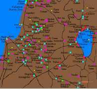
The following map of Israel shows all the reviewed sites in BibleWalks. Select either satellite or map types. The reviewed sites are represented with colored icons shaped as ![]() . Their colors indicate classes of sites:
. Their colors indicate classes of sites:
● Blue = Old Testament
● Red = New Testament
● Purple= other ancient periods,
● Green= prehistoric, nature
● Yellow= regional galleries
Clicking on the site’s icon will open an info window with the title, location and link to the review page.
(3) Biblical & Historical maps:
-
- The Tribes – map of the Biblical tribes of Israel (Galilee tribes)
- Jesus Travels – map of sites where Jesus has traveled, and mapped to the sites that are featured in BibleWalks.com.
- Crusaders sites – map of fortresses and other sites of the Crusaders
- Nabatean sites – map of the sites of the Nabateans
(4) External Maps References:
- A Christian’s map of the Holy Land (Blustein; pdf)
- Jerusalem and Holy Land ancient maps (USM, Osher)
- Israel Maps (Univ. Texas @ Austin)
- Topo maps with PEF survey overlay (“Amud Anan” – a great navigation tool)
- Survey of Western Palestine (19th century) – see our References
- Archaeological Survey of Israel (Hebrew/English) – Highly recommended resource.
- Topographic maps and Hiking trails (new; includes British Mandate topo map)
- British Mandate detailed Map 1:20,000, and others
![]()
BibleWalks.com – puts you on the map with the Bible
Ancient Games<<<—Previous —<<< All Info >>>—Next Info—>>> Museums
This page was last updated on Mar 13, 2024 (move gallery of maps to the sites overview; add sites map)
Sponsored links: