Ruins of a village near Beit Shemesh, identified as the home town of Samson’s Delilah.

Home > Sites > Judea > Beth Shemesh > Horvat Kefar Sorek
Contents:
Overview
Location
History
Photos
* Views
* Kefar Sorek
* Well and Spring
* Monastery
* Wine
* Nature
* Aerial Video
Biblical References
Etymology
Links
Overview:
On a ridge on the north side of Nahal Pla’i valley, near Beit Shemesh, are ruins of a ancient village. It is identified as the home town of Samson’s Delilah. On the south side is the monastery of Deir Rafat.
(Judges 16:4): “And it came to pass afterward, that he loved a woman in the valley of Sorek, whose name was Delilah”.
Location:
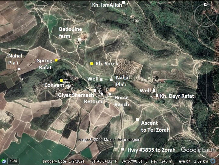
The following aerial view shows the points of interest. Khirbet Sorek (also known as Horvat Kfar Sorek) is located on a ridge north of the valley of Nahal Pla’i. Along the valley, which feeds into Nahal Sorek, are several springs and wells. South of the valley, on the ridge (named Givat Shemesh) are the Catholic convent, an addiction prevention and treatment center (Retorno), and a horse ranch.
History:
- Bronze Age
Tribes of Israel: The area around Beth Shemesh was initially given to the tribe of Dan (Joshua 19 41): “And the coast of their inheritance was Zorah, and Eshtaol, and Irshemesh”.
- Iron Age:
Judges period (12th-11th century BC): Recent excavations in the adjacent city of Beth Shemesh revealed Canaanite architecture and ceramics, but the study of the remains of animal bones indicated that the diet excluded pigs which imply an Israelite presence.
The sites and roads during these periods are indicated on the Biblical Map below. This site is indicated as a red point, and is positioned west of Iron Age villages – Zorah (home town of Samson) and Eshtaol.
According to D. Dorsey (“Roads and Highways of ancient Israel”, p. 187), road “J5” from Jerusalem to the port city Yavne-Yam passed thru Nahal Kesalon (Chesalon), then westwards thru Eshtaol, passing thru Beth Shemesh west to Biblical Timnah along the valley of Sorek. A branch of the road bypassed Beth Shemesh, passing thru Zorah and this site.
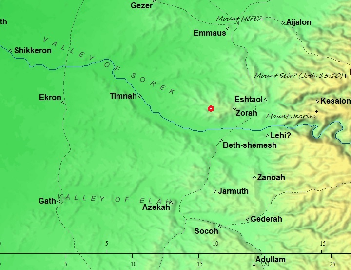
Area around K. Sorek – Biblical through Roman periods (based on Bible Mapper 3.0)
Samson:
During the 12th century the Philistines arrived to the cities along the shore. Beth Shemesh and the villages in the Sorek valley were located on the border with the Philistines, and were affected by their push from the shore eastwards into the land of Judah.
Their conflict with the Israelites started in the mid 11th century BC, and one of the stories associated with this conflict is the heroism of Samson of the tribe of Dan, who was born in the nearby village of Zorah (3km east of the site). The mighty Samson was a judge for 20 years, and battled with the Philistines. The name Samson means “man of the Sun”, so even his name is related to Beth Shemesh – the “house of the sun”.
Delilah:
Delilah was, according to the Biblical story, Samson’s 3rd wife. The Bible does not reveal if she was a Philistine, Canaanite or Israelite. She was from a nearby place in the valley of Sorek (Judges 16:4):
“And it came to pass afterward, that he loved a woman in the valley of Sorek, whose name was Delilah”.
Biblical Delilah was sort of a “femme fatale” (French for ‘deadly woman’) – a beautiful, seductive woman whose charms trap her lovers and lead them to their demise. The Biblical story shows how she plots to obtain the secret of Samson’s strength, for money, and delivers the weakened hero to his end by the Philistines.
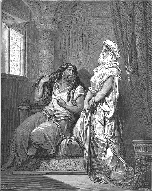
Samson and Delilah –
drawing by Gustav Dore (French artist, 1832-1883)
Delilah betrayed Samson to the Philistines for a promised booty (Judges 16:5):
“And the lords of the Philistines came up unto her, and said unto her, Entice him, and see wherein his great strength lieth, and by what means we may prevail against him, that we may bind him to afflict him: and we will give thee every one of us eleven hundred pieces of silver”.
Delilah tried several times to reveal the source of Samson’s strength (Judges 16:6):
“And Delilah said to Samson, Tell me, I pray thee, wherein thy great strength lieth, and wherewith thou mightest be bound to afflict thee”.
Samson first tricked her with three false sources of his strength. However, due to his love to Delilah, he eventually gave up his secret: keeping a vow of growing his hair as a devotion to God (Judges 16: 17):
“That he told her all his heart, and said unto her, There hath not come a razor upon mine head; for I have been a Nazarite unto God from my mother’s womb: if I be shaven, then my strength will go from me, and I shall become weak, and be like any other man”.
Delilah cut his hair during his sleep. Samson indeed lost his powers, and she surrendered him to the Philistines (Judges 16:18-19):
“And when Delilah saw that he had told her all his heart, she sent and called for the lords of the Philistines, saying, Come up this once, for he hath shewed me all his heart. Then the lords of the Philistines came up unto her, and brought money in their hand. And she made him sleep upon her knees; and she called for a man, and she caused him to shave off the seven locks of his head; and she began to afflict him, and his strength went from him”.
The Philistines blinded Samson, and carried away him to Gaza (Judges 16:21).
“But the Philistines took him, and put out his eyes, and brought him down to Gaza, and bound him with fetters of brass; and he did grind in the prison house”.
Samson died in cavity in Gaza by pulling down the temple with his incredible strength (Judges 13-16).
- Later periods
The site was occupied in the Roman and Byzantine periods.
-
Byzantine period (4th-7th Century AD)
Eusebius Pamphili (better known as Eusebius of Caesarea), a 4th Century Greek historian of the Church, wrote in his book “Onomasticon” about the site (translated):
“Sōrēch – (Name of) wadi. Home of Dalila wife of Samson. It is (today) the village called Sōrēch (Cafarsorch) north of Eleutheropolis [Beit Guvrin] near (the hamlet) [small settlement] Saraa [Zorah] the home of Samson”.
-
Ottoman period – PEF survey
The area was examined in the Palestine Exploration Foundation (PEF) Survey of Western Palestine (SWP), conducted 1866-1877 by Wilson, Conder and Kitchener. A section of their map is shown here, with Khirbet Surik on the foothills above Wadi Ayun (Hebrew: Nahal Pla’i) which flows into Wady es Surar (Nahal Sorek). The convent is not shown on the map, as it was established in 1927 (50 years later).
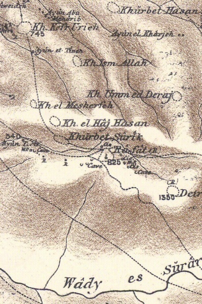
Part of Map Sheet 17 of Survey of Western Palestine, by Conder and Kitchener, 1872-1877.
(Published 1880, reprinted by LifeintheHolyLand.com)
The surveyors wrote about the site (SWP, Vol 3, p.126):
“Khûrbet Sûrîk (J t).—Traces of a ruined village, springs, with a rock-cut wine-press and cave to the west, and a sacred tree”.
The surveyors identified it as Caphar Sorech (SWP, Vol 3, p. 53):
“Sorek (Valley) (Judges xvi. 4).—A town called Caphar Sorech is mentioned in the ‘Onomasticon ‘ as near Saraa (Surah), evidently the present ruin of Khurbet Surik. This would point to Wady es Surar as the Valley of Sorek ; and this valley is still inhabited by Bedawin, much as the Philistines probably lived in it amongst the settled Jewish population”.
- British Mandate
Deir Rafat, a Catholic monastery ,was established in 1927. The complex was located on a hill, on the south bank of the valley. It was named the “Shrine of our Lady Queen of Palestine and of the Holy Land”, and contained a convent, boarding school an orphanage.
A 1940s British map shows the area around the site. Khirbet Sorik (Sorek) is located north of the convent, but is not marked here. The map shows the convent on the left side
The map also shows the Arab village of Dayr Rafat on the right side (1 KM to the east of the convent). Ruins of this village, destroyed in 1948, are adjacent to the well (“En Naura”), now on the edge of Zorah forest. The PEF survey wrote about the site (Vol 3. 155): “Rafat—Traces of ruins. Cisterns, winepresses cut in rock and rough pillar-shafts, with ruins of a modern village and a Mukam”.
British survey map 1942-1948 – https://palopenmaps.org topo maps
License: public domain under the UK Copyright, Designs and Patent Act 1998
Kh. Ism Allah is 1km north east of the convent. This is a large 20 dunam multi period site, with continued settlement from the Iron Age II to the British mandate period. The PEF survey merely wrote about this site (Vol 3, p. 115) as “foundations”.
- Modern time
In recent years the monastery is running a guest house and retreat center for pilgrims and believers. It is producing and selling wine (“Mony”) and ceramics.
East of the convent is an addiction prevention and treatment center (Retorno), and an adjacent horse ranch.
The valley and the ruins are in open public area and can be accessed from a road that descends from the hill. Follow the signs from hwy #38, on the junction north of Tel Beit Shemesh, to “Giv’at Shemesh” (Sun hill).
Photos:
(a) General Views
Here are some views around the site. This view towards the north.
The ruins of Kefar Sorek are scattered on a ridge above the north bank of Nahal Pla’i stream, which feeds into Nahal Sorek stream. The ridge is 40m above the stream.
Click on the photos to view in higher resolution…
On the ridge are remains of structures, cisterns, caves and installations.
The sheep and goats were passing thru the site.
To the north west of the ruin is a Bedouin farm.
To the south of the valley is the monastery.

Viewing west – the valley of Nahal Pla’i flows westwards and joins Nahal Sorek.
Another view is towards the east. In the forest on the far left background is Zorah – the home town of Samson. The road to Zorah was along the valley.
On the bottom of the hill, where today is a Bedouin farm, are ruins of the Arab village of Rafat.
(b) Kefar Sorek
The ancient site was not yet excavated. Its ruins are scattered on the ridge.
On the foothills are traces of walls and structures, caves and cisterns.
Kefar Sorek was a farming village, so remains of agriculture installations are bound to be find among the ruins. Indeed, during our short survey, we have noticed some of such elements. For example, fragments of an oil press were found during our review of the ruins. This piece is a fragment of a rolling stone:
Adjacent to the stone is another element – a weight for pushing down the lever to squeeze the olives.
North of the ruin is another type of farming installation. Along the vertical cavity of the cave are holes along the walls. This was a Columbarium, which is common in Judea. The installation was used to grow pigeons and doves for food and/or for fertilizer production. The word ‘columbarium’ is based on the Latin word columba (‘pigeon’), as it was originally used for a place to house doves and pigeons.
(c) Well and spring
A well, partially covered by arches, is located in the valley south of the ruin. The well is approximately 3m in diameter and 5m deep. On the British map it is named “Bir Qaubar”.
Parts of the structure is built with cement. Inside the well is a metal frame that used to hold a pump.
On the north west foothill of the convent, west of the site, is the Rafat spring.
The spring’s water flow into the Pla’i valley.
Valley Pla’i is named after the angel that appeared to the wife of Manoah – Samson’s father. The wife was barren, but the angel told her she will conceive a son. In the Hebrew source the angel was named Pla’i, but the KJV translation changed it to being a secret (Judges 13:18): “And the angel of the LORD said unto him, Why askest thou thus after my name, seeing it is secret?”.
(d) Monastery
On the south side of the Pla’i valley is a ridge. On its west side is Deir Rafat monastery. This Catholic monastery ,was established in 1927 and named the “Shrine of our Lady Queen of Palestine and of the Holy Land”.
The statue of Mary, with the underlining Latin words ‘Reginæ Palæstinæ’ (=to the Queen of Palestine), appears standing tall above the entrance.
The church interior is seen below.
On the walls and ceilings are illustrations of angels holding banners with the first words of prayer “Hail Mary!” (Latin: Ave Maria) in 280 languages.
(e) Wine
In this area are many vineyards. The soil here is perfect for growing grapes, used to craft quality wine.
The Sorek valley is one of the winery epicenters in Israel. In a close vicinity around Sorek are many wineries. Some are large established wineries, but most are smaller, family operated wine producers. The wineries are: Taperberg, Mony, Tzorah, Sorek, Bravdo family, Samson and Delilah, Kadma, Clos de Gat.
Teperberg, a large wine manufacturing plant, is located near Tzorah, 2 kilometers southeast of the site. Teperberg winery was founded by Avraham Teperberg in 1870 in Jerusalem, and considered as Israel’s oldest winery.
A younger boutique winery is located in the Deir Rafat monastery, named “Mony”. The Artool family winery was founded in 2001 and named in memory of son Mony. The family grow their own grapes and age the wine in a cave. While visiting the monastery be sure to visit the company store behind the monastery, taste their wine, and buy some bottles.
The wine aging caves were constructed by the monks about 100 years ago.
(f) Nature
In the spring time there are wild flowers that color up the fields and foothills.
One such flower, seen in early April, is the “Israeli Luf” (Latin: Arum Palaestinum). We were surprised to find so many such flowers of this kind, as in other places in Israel they come in small numbers.
Another flower seen in early April: – a low growing purple-blue and white flower – the Barbary Nut Iris.
(g) Aerial Video
![]() Fly over the site with this YouTube video. The drone surrounds the area of the ruins ‘clockwise’ starting from the valley side.
Fly over the site with this YouTube video. The drone surrounds the area of the ruins ‘clockwise’ starting from the valley side.
Video and photos captured on Apr 2022
Etymology:
- Nahal Sorek – The stream on the north side of Beth Shemesh, flowing from north Jerusalem westwards to the sea. (Hebrew) Nahal – stream, Sorek – a type of grapes used for red wine. The Arabic name of the valley is called Wady es Surar.
Biblical references: A single Biblical verse refers to Sorek, describing the area where Samson operated (Judges 16 4): “And it came to pass afterward, that he loved a woman in the valley of Sorek, whose name was Delilah”.
Sorek is a Biblical form of a reddish color and also a type of grape used to make red wine. In the following verse the Hebrew word for vine is Sorek (Isaiah 5 2):
“And he fenced it, and gathered out the stones thereof, and planted it with the choicest vine, and built a tower in the midst of it, and also made a winepress therein: and he looked that it should bring forth grapes, and it brought forth wild grapes”.
The word Sorek is used for the red color (Zechariah 1:8): “I saw by night, and behold a man riding upon a red horse, and he stood among the myrtle trees that were in the bottom; and behind him were there red horses, speckled, and white.
Nahal Sorek, as seen from Tel Beit Shemesh
- Giv’at Shemesh – Hebrew: sun hill (the ridge of the convent and Retorno)
- Rafat – an Arab private name, meaning: acts of kindness”.
- Deir Rafat – the monastery of Rafat, was named after the nearby village.
- Kh. Ism Allah – Arabic: the ruin of the name of God.
Links and References:
* Archaeology:
- Zorah and Eshtaol identification – Prof. Yoel Elitzur (2015)
* Biblical:
- Delilah’s attempts to reveal Samson’s secret (Hebrew)
- Onomasticon -translation
* Internal – sites nearby:
- Zorah – Samson’s home town
- Tel Beth Shemesh
- Valley of Elah
- Beit Jamal
- Kh. el ‘Alya
- Tel Yarmut
- Gath – Philistine city, home of Goliath
* General information:
- Retorno – addiction prevention and treatment center
* Other:
- Biblical pictures by Gustave Doré (1832-1883)
- Wild Flowers in the Holy Land
Beit Jamal<<<—previous site–<<< All Sites >>>—next Judea site—>>> Zorah
![]()
This page was last updated on Apr 20, 2022 (new photos)
Sponsored links: