Biblical sites near an ancient crossings of the Jordan river at Tell Abu Sus and Tell Sakut.
Home > Sites > Jordan Valley > Tell Abu Sus and Tell Sakut
Contents:
Background
Location
History
Identification
Photos
* Tell Abu Sus
* Ein Sakut
* Tell Sakut
Videos
Etymology
Links
Background:
During the Bronze and Iron Ages the Jordan River was crossed at selected fords rather than bridges. Ancient sites surround one of the major crossing point in the southern Beit Shean valley. (Joshua 2:7): “And the men pursued after them the way to Jordan unto the fords…”.
Two major sites are located in this location – Tell Abu Sus and Tell Sakut. Both sites are suggested to be the Biblical city of Abel-Mehola, the birth place of prophet Elisha, although there are other candidates of its location.
Location:
Tell Abu Sus and Tell Sakut are located near the river crossings thru the fords along the Jordan river. The spring of Ein Sakut, the main source of water during the antiquity in this area, is accessible by a road from highway #90 (Beit Shean to Jericho).
Tell Abu Sus is 244m below sea level – rises 50m above the river. Tel Sukkot is 216m below sea level, just 10m above its surroundings.
History:
The multi-period sites of Tell Abu Sus and Tell Sakut were inhabited since the Early Bronze period until the Middle Ages. They commanded the river crossings that supported the trade routes connecting the land of Israel to the Trans Jordan mountains and beyond.
-
Biblical map
The cities and roads during the Canaanite and Israelite periods are indicated on the Biblical Map below, with the crossing point marked by a red dot on the west bank of the Jordan river. The red dot indicates the location of Tell Abu Sus, and is labeled as “Abel-Meholah” – one the Biblical identifications of the ancient city.
Map of the area of Beit Shean valley – during the Canaanite and Israelite periods (based on Bible Mapper 3.0)
David Dorsey (“The roads and Highways of Ancient Israel”, 2018, pp. 104, 114, 172-173) listed 3 Bronze/Iron age roads that came through the sites to the river crossing at Tel Abu Sus:
- T9b – from Rehov to Tel Abu Sus (sites #272 thru 277) – This road connected Rehov, the most important city in the area, through the following sites: Tellul eth Thaum, Tel ‘Alya, Tell er Ridhghah (Tel Shalem), Tel Muleiqat and Kh. Khisas ed Deir to Tell Abu Sus
- S13 east – from Qa’un and Tel Malqoah to Tel Abu Sus – This road, branching off from the main ancient highway “A3” (Beit Shean-Rehob-Jericho), connected through Kh. Khisas ed Deir to Tell Abu Sus.
- S14 east – This road connected the road from Samaria, exiting the esh Shakk valley, along the eastern edge of Wadi Malih, to Tell Abu Sus and Tell Sakut
- River crossing in antiquity
In the antiquity the Jordan river crossings was by crossing fords along the river rather than using bridges or ferries. Bridges were constructed only during the Roman and Mameluke periods. Dorsey (“The roads and Highways of Ancient Israel”) claims that no Bronze or Iron Age bridges were found along the Jordan, and the Bible does not mention such bridges.
During the antiquity the Jordan river was more powerful and harder to cross, so trade routes connecting the west to east had to select the most convenient location for the crossings. This changed in modern times, as the source of the Jordan river was blocked in 1932 by the Degania dam on the south side of the Sea of Galilee, and the river turned into a slow flowing creek.
See Kfar Ruppin sites – another major river crossing.
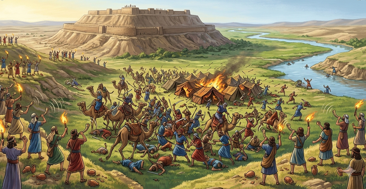
Tell Abu Sus and Tell Sakut were built on the banks of the Jordan river, and controlled the river crossing. An AI illustration shows a probable view of the Iron Age site along the Jordan river, as seen from the east side.
Abel Mehola Iron Age river crossing – AI generated – Gemini / BibleWalks Collection
- Late Roman/Byzantine period
A Roman road, arriving from Samaria thru the esh-Shakk valley, followed the Bronze/Iron age S14 route. Zertal marked the road “B8” in the Manasseh Hill Country Survey (Volume 2). It passed along the northern bank of Wadi Malih, passing on the north side of Kh. el-Marma (near highway #90), then arriving via Ein Sakut to the river crossing point. Remains of a soling road is seen along the Wadi Malih near the bridge of highway #90.
-
Ottoman period
Edward Robinson, the “father” of Biblical Geography, visited the site on his travels in 1852 (E. Robinson, published 1857, “Biblical researches in Palestine, and in the adjacent regions, 1852”, pp. 309-312):
“We passed down along the southern slope of the swell, having the channel of Wady Malih about three quarters of a mile distant on our right. On the very eastern point of the swell, which here forms a low bluff not far from the lower valley of the river, we came at 10.20 to Sakut. Here is seen merely the ruin of a common village, a few foundations of unhewn stones. The eastern bank of the lower Jordan valley opposite to us was precipitous, apparently nearly a hundred and fifty or two hundred feet high ; and the river was running close under it about half a mile distant from us. The water of the river was not in sight, because of the bushes and trees ; but we afterwards saw it from a point a little farther north….
Near the foot of the low bluff of Sakut, towards the east, there breaks out a beautiful fountain of pure and sparkling water, under the shade of a thicket of fig trees. Here we took our lunch, and enjoyed both the water and the shade. In this deep shade and by this bubbling fountain, the thermometer at 11^ o’clock stood at 92°.”.
Robinson continues in the following pages to discuss the identification of the site with Biblical Succoth.
The site was examined in the PEF survey (1866-1877) by Wilson, Conder and Kitchener. They merely described Tell Abu Sus as a very large ancient Tel, but did not elaborate (Volume 2, sheet XII, p. 246):
“Tell Abu Sus —A very large artificial mound, standing isolated near Jordan”.
A section of their map is shown here.
The river crossings (marked as Mak.t – short for Makhadet – Arabic for ‘ford’) appear as a short lines north and south of Tell Abu Sus.
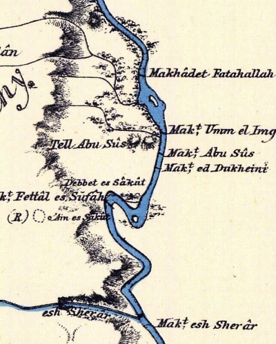
Part of Map sheet 12 of Survey of Western Palestine,
by Conder and Kitchener, 1872-1877.
(Published 1880, reprinted by LifeintheHolyLand.com)
They added more information on the nearby Ain es Sakut: (p. 234):
“‘Ain es Sakut —There are here heaps of stones and foundations round the spring, and wild fig-trees. The site is close to the
Zor, on a sort of promontory, with the spring lower down. The place seems once to have been a small village.”
The surveyors added an identification of Ain es Sakut (p. 231):
“Succoth (Gen. xxxiii. 1 7).—Robinson has proposed to place this at Sakot, but Mr. Grove argues that it should be sought east of Jordan. The name Sakut is radically different from Succoth”.
- British Mandate
A 1940s British map shows the area around the site with more details. The site is marked here as “Tell es Sus” and “Kh. es Sakut”. The Jordan river passes on the eastern side of the map.
Tell Abu es Sus governed 2 river crossings: Makhadat (ford) Abu es Sus on its south side, Mkhadat Fat-Hallah on its north side.
Less than 1km south of Tell Abu Sus was another ford – Mkhadat Fattal es Safah. It is closer to Kh. es Sakut – and to the major source of water in this area – Ein as Sakut.
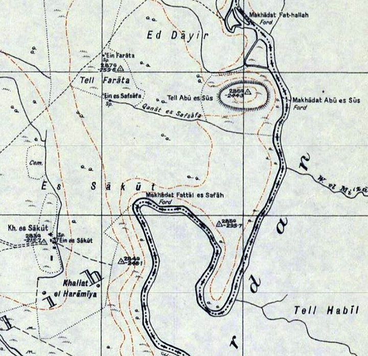
British survey map 1942-1948 – https://palopenmaps.org topo maps
License: public domain under the UK Copyright, Designs and Patent Act 1998
-
Modern Times
Both sites were surveyed by the Manasseh hill country survey, headed by Adam Zertal. Their report is detailed in Volume 4 sites 32-33 (published in 2005). Other surveys of Sakut were by Gophna and Porath (1972, site 52), and Abu Sus by N. Zori (1977, site 56).
Getting there: Tell Sakut and Ein Sakut are accessible by car from a turn on highway #90, 1km east of Moshav Mehola. A sign is posted on the side of the highway just before the bridge over Wadi Malih. Visitors come to swim in the pools. However, Tell Abu Sus is not permitted for entrance since it is a military fort on the Jordanian border.
Identification
a. Biblical References to Abel Mehola
Both Tell Abu Sus or Tell Sakut are identified as Biblical Abel Mehola by many scholars. Here are Biblical references to Abel Mehola:
- Abel Meholah is mentioned in the events following the battle between judge Gideon and the Midianites (Judges 7:22):
“And the three hundred blew the trumpets, and the LORD set every man’s sword against his fellow, even throughout all the host: and the host fled to Bethshittah in Zererath, and to the border of Abelmeholah, unto Tabbath”.
Gideon’s pursuit at border of Abel Mehola – AI generated – Gemini / BibleWalks Collection
The Israelite pursuit passed at the “border” (Hebrew: Sfat”) of the Abel Meholah, which some scholars interpreted it as the bank of the (Jordan) river where either Tell Abu Sus or Tell Sakut are located.
2. Abel Meholah is listed in King Solomon’s 5th province (1 Kings 4:12):
“Baana the son of Ahilud; to him pertained Taanach and Megiddo, and all Bethshean, which is by Zartanah beneath Jezreel, from Bethshean to Abelmeholah, even unto the place that is beyond Jokneam”.
This verse can be interpreted as placing the place at the southern edge of the valley of Beit Shean, where both Tells are located.
3. Abel Meholah is also mentioned as the home place of prophet Elisha, the successor of Elijah (1 Kings 19:16):
“And Jehu the son of Nimshi shalt thou anoint to be king over Israel: and Elisha the son of Shaphat of Abelmeholah shalt thou anoint to be prophet in thy room…”
Elijah visited his pupil in Abel Meholah during his work in the field. Scholars base the identification of Abel Mehola on the vast size of the farming field (1 Kings 19:19):
“So he departed thence, and found Elisha the son of Shaphat, who was plowing with twelve yoke of oxen before him, and he with the twelfth: and Elijah passed by him, and cast his mantle upon him.”
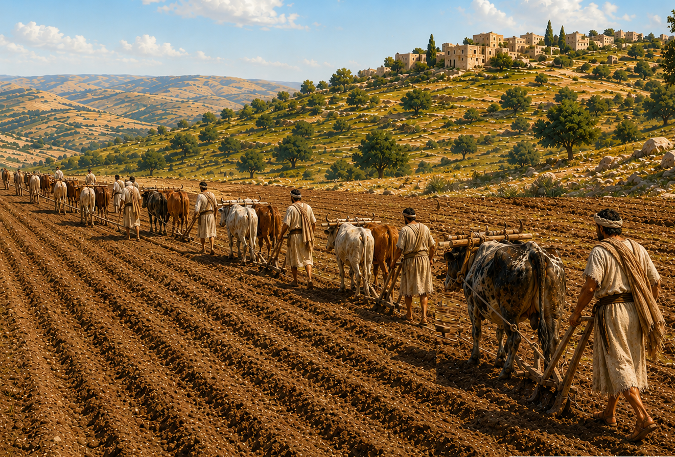
Elisha plowing with 12 Yoke of Oxen– AI generated – ChatGPT / BibleWalks Collection
Indeed, most scholars identify Abel Meholah to be within an area closer to the Jordan river. However, there are some that suggest other sites that are more inland. These rely on Eusebius of Caesarea, a 4th Century Greek historian of the Church, who added an identification in his book “Onomasticon” about the site (Abelmaelai, Abelmaula) that its in “…a little village Abelmea seen on the road from Neapolis [Shehem] to Scythopolis [Beit Shean]”.
Searching along this road for sites with Bronze/Iron Age remains, some scholars suggested Tell el Hilu along the Wadi Malih valley route, or Khirbet Mhallal located near the Malih springs. However, both sites lack Byzantine remains (as a village existed during Eusebius time), and they are not within a vast agriculture area, nor a valley which has running waters (the meaning of Abel). Conversely, the Tells Sakut or Abu Sus meet these features.
b. Biblical References to Sukkoth
Tell Sakut may have preserved the name of another Biblical place – Sukkoth. There are several references to Sukkoth in the Bible, and they could refer to different locations bearing the same name: one at a more southern location on the eastern side of the Jordan river, while another on the western side – perhaps at Tell Sakut which may have preserved the old name.
Sukkoth is also mentioned in Gideon’s pursuit against the Midianites (see above), after his army crossed the river. Here, Gideon requests food from the people of Succoth (Judges 8, 4-6):
“And Gideon came to Jordan, and passed over, he, and the three hundred men that were with him, faint, yet pursuing them. And he said unto the men of Succoth, Give, I pray you, loaves of bread unto the people that follow me; for they be faint, and I am pursuing after Zebah and Zalmunna, kings of Midian. And the princes of Succoth said, Are the hands of Zebah and Zalmunna now in thine hand, that we should give bread unto thine army?”.
Since the described location of the place is near the river crossing, and close to Abel Meholah, a possible identification could be that Tell Abu Sus is Abel Mehola while Tell Sakut is Sukkoth. However, there could be other possible sites.
Photos:
(a) Tell Abu Sus
Tell Abu Sus is a large, elevated mound that rises over the course of the Jordan river on its west side. This ancient city covers an area of 30 dunams, and was one of the important sites protecting the adjacent Jordan river crossing. At an altitude of 244m under sea level, it soars 50m above its surroundings.
The hill is occupied by the military and is closed to the public.
Click on the photos to view in higher resolution…

A road leads from the Israeli side down to the border road which is in a restricted area. The area around the hill is fenced off and is mined.
The course of the river is from left (north) to right (south). The river crossing points are through the fords on both sides of the hill – Mkhadat Fat-Hallah 500m north, and Makhadat Abu es Sus 500m south.
Below is a view from the north west side of Tell Abu Sus. The site is built on the summit of 2 hills – an eastern hill (left) and a western hill (right).
We were granted a special visit to the enclosed area, and walked up to the top of the hill.

The steep ascent to the summit was not an easy walk…

Along the road are great northern views of the Jordan valley.
The river flows from left to right. Due to the bends of the river, the stream at this point was slower, allowing to cross the river.

The eastern side of Tel Abu Sus towers over the valley. This is a view towards the north east.

On the southern side of Tel Abu Sus was another river crossing, seen here in this view towards the south east.

A team of leading Biblical archaeology scholars, including the staff of BibleWalks, visited this site on June 15, 2026. The team was headed by the distinguished Israeli archaeologist, Professor Emeritus Amichai Mazar (in the red shirt).

This is the view of the western hill of Tel Abu Sus. Its eastern side was cut open.

A closer view of the cut side of the western hill is seen below. On the north side are remains of a modern military post.

- Ceramics dating:
Ceramics collected on the mound and on its foothills were dated by the Manasseh Hill Country survey (2005) to the following periods: Chalcolithic period (4%), Early Bronze 1-2 (27%), Middle Bronze II (9%), Late Bronze 1-2 (15%), Iron I (10%), Iron II (16%), Persian (4%), Hellenistic (2%), Byzantine (8%) and Middle Ages (5%).
Flintstones were dated to the Early Bronze period.
(b) Ein Sakut
The spring of Ein Sakut (Arabic: ‘Ain Sakut) is the main water supply in this area. The spring and its pools attract visitors, such as seen in the photo, who come to enjoy swimming in the waters.
Archaeologist Ayelet Goldberg-Keidar, who led the short survey of the site, examines the waters. Uncle Ronnie is standing on the right side.
(c) Tell Sakut
Tell Sakut (Arabic: Khirbet es-Sakut) is a large (40 dunam) multi-period archaeological site, adjacent to the spring. Its height is 216m below sea level, rising only 10m above its surroundings. The site is located 1.8km south west of Tell Abu Sus, and 800m west of the Jordan river.
This view, towards the north east, shows the eastern foothills of Tell Sakut and the area of the spring just below it. In the center of the far background is Tel Abu Sus.

Due to the military constructions that reshaped the hill, the area of the ancient city is not certain. According to the ceramic survey, the Tel extends to the north over 500m, even beyond its current topography.
On the summit the military cut trenches along the eastern side.
On its west side the area is mined and so cannot be accessed.
In the center of the top of the hill a large military ditch totally reshaped the summit. The ditch is 2.5m deep and covers and area of 75 x 25m.
On the south side is a dirt road that connects the site to Wadi Malih. In antiquity this was the route connecting Samaria thru the valley of Esh-Shakk to Tell Sakut.
At the side of the road is a deep round hole – the result of an illicit digging.
- Findings:
Ceramics collected on Tell Sakut and on its foothills were dated by the Manasseh Hill Country survey (2005) to the Chalcolithic period (6%), Mid Bronze II (14%), Late Bronze (8%), Iron I (11%), Iron II (10%), Persian (7%), Hellenistic (2%), Late Roman (12%), Byzantine (6%), Early Muslim (8%), and Middle Ages (8%).
The following are few samples of interesting findings found during our short survey across the site. First, a collection of items we saw:
Note that all items were returned to their original location.
Here are some sample identifications:
a. Roman/Byzantine vessel:
b. Biblical basalt grinding base:
c. Iron Age I-III vessel:
d. A Modern piece:
e. A collection of glass, ceramics vessels and misc. – from Roman until Crusaders period:
Video Tour
A visit to Tell Abu Sus on June 2026 with a group of Biblical archaeologists.
Etymology (behind the name):
- Tel (Tell) – mound (See more on the story of a Tel).
- Makhadet – Arabic: Ford
- Ein Sakut – Arabic (according to PEF dictionary): the dropping spring (a small cascade).
- Abel, Avel – Avel means in ancient Hebrew: a fertile valley with flowing waters. A modern Hebrew form is Yuval – river or creek, such as the name of Kefar Yuval. There are a dozen of sites in Israel with the prefix “Avel”, such as Abel Meholah, Abel Beit Maacah, …
- Meholah – perhaps: dance (Hebrew)
- Abel Mehola – literally meaning: “The fertile valley of the land of Mehola”
- Mehola, Shadmot Mehola – two nearby Moshav communities (along highway #90), named after Abel Mehola; founded 1967 and 1979.
- Abu: Arabic: father of-
- Sus – Arabic – unknown?
Links:
* External, archaeological links:
- “The Manasseh hill country survey” Volume 4 [Adam Zertal , ISBN 965-311-012-8, 1996, pp. 251-259, Hebrew]
- Site 32: Khirbet es-Sakut
- Site 33: Tel Abu Sus
- N. Tzori 1962
- Crossing the Jordan river during the Biblical period – north versus south – David Moster, Aram 29 (2017), pdf
- Late Bronze Survey in Jordan valley – James Mark Schaaf (545 pages, 2012, thesis, Univ S. Africa); great resource!
- Bergman & Brandsteter Arch. surveys in Beit She’an valley (1940-1941:86-90, Hebrew)
- Survey of Tel Rechov area – Ahia Cohen-Tavor , 2010, Hebrew Univ, Hebrew
- Geographical and Historical Observations on the old North Israelite Gideon tale in Judges – Israel Finkelstein and Oded Lipschits, ZAW 2017
* External, other links:
- Biblical pictures by Gustave Doré (1832-1883) – public domain
* Other River Crossing sites:
* Internal links:
- Abu Sus/Sakut on Jordan Valley sites map
BibleWalks.com – exploring the ancient sites of Israel
Kfar Ruppin sites<<<—previous Jordan Valley site—<<< All Sites>>> — Next site—>>>Horvat Ziwan
This page was last updated on June 23, 2026 (add visit photos to Tel Abu Sus)
Sponsored links: