Ruins of a Israelite period desert fortress and small settlement, near the confluence of Nahal Boker and Haro’a streams with HaBasor stream.

Home > Sites > Negev > Horvat Ritma (Rithmah)
Contents:
Background
Location
History
Photos
* Aerial view
* Fortress
* Commander’s house
* The Area
* Video
* Nearby sites
Etymology
Links
Overview:
Ruins of a Israelite IIa period desert fortress and small settlement, on the southern bank of Nahal Boker. The fortress was also occupied during the Persian and Nabatean periods. It overlooked the vast valley, and guarded the ancient east-west desert route that passed Nahal HaBesor.
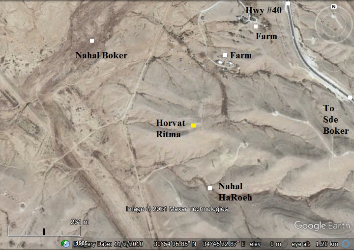
Location and Map:
The site is located about 3KM north-north-west of Kibbutz Sde-Boker, 0.5km west of highway #40 from BeerSheba to Mizpeh-Ramon. A dirt road leads from the farms to the foothills where the ruins are located.
History:
-
Iron Age IIa period (1000-925 BC)
In the Negev area are over 40 fortresses of small to large sizes that were identified as “Israelite fortresses’ and dated to the Judean Kingdom period. The majority had common features – located near major trade routes, a plan of central courtyard with casemate rooms, have been built around the 10th century BC, and had small 4-room houses were built at their side.
The fortress of Horvet Ritma is one of the small forts. The fortress, built in the 11th-10th century, overlooked a vast area of the valley where a major trade route passed. Several dwelling structures were built around the fortress. The site existed for a short period, but was later used during the Persian and Nabatean periods.
- Who built the desert fortresses?…
Who built this fortress, as well as others in the desert area? Scholars offer various identifications. Some relate their construction to the royal administration of the Judean Kings, such as David and Solomon (only the small forts), or to Jehoshafat (870-849 BC) and Uzziah (mid 8th century) for the large fortresses with towers.The fortresses offered protection on the major trade routes and established control and royal presence.
The Bible tells us about these desert constructions (2 Chronicles 26: 9-10):
“Moreover Uzziah … built towers in the desert, and digged many wells: for he had much cattle, both in the low country, and in the plains…”.
Other scholars, however, offered other identifications such as relating their construction to the actions of the desert tribes – whether Israelite or foreign tribes.
- Trade route:
The area of Sde-Boker was a junction of ancient crossroads. One of these routes (known as the Incense & Spice route during the Roman/Nabatean period) led from Oboda (Avdat) to the port city of Gaza and the north of Israel. Its location is marked as a red square on the Biblical map below.
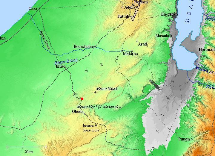
Map of the area around the site (marked by red square) – during the Roman/Byzantine periods (based on Bible Mapper 3.0)
-
Modern Period
The site was excavated by R. Cohen and Z. Meshel (IAA) in 1969-71. Five areas were examined:
- The fortress
- A 4-room building south of the fortress (“the commander’s house”)
- Remains of a settlement on the eastern foothill – 3 excavated structures (of 10)
- Three cisterns
- Tombs on the western foothill
The ceramics were dated to the Israelite period II, Persian and Nabatean.
The site is in an open public area, not far from highway #40.
Photos:
(a) Aerial Views
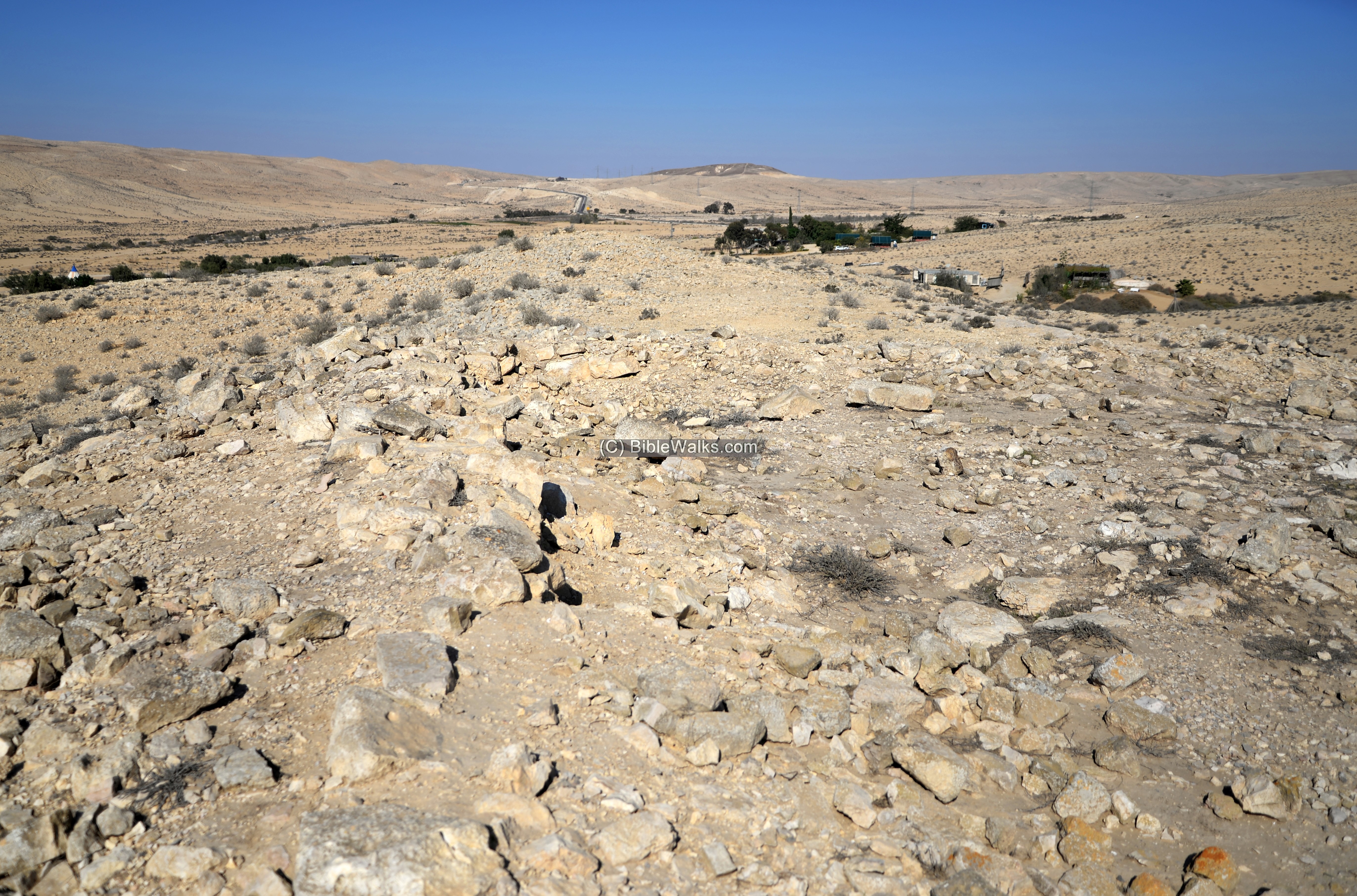
A drone captured this view of the site from the south side.
The closer ruin is a ‘four-room’ house, with an area of 8.0 x 9.5m, named by the archaeologists as the ‘commander’s house’. Behind are the ruins of the fortress, a square 21m x 21m structure.
Click on the photos to view in higher resolution…
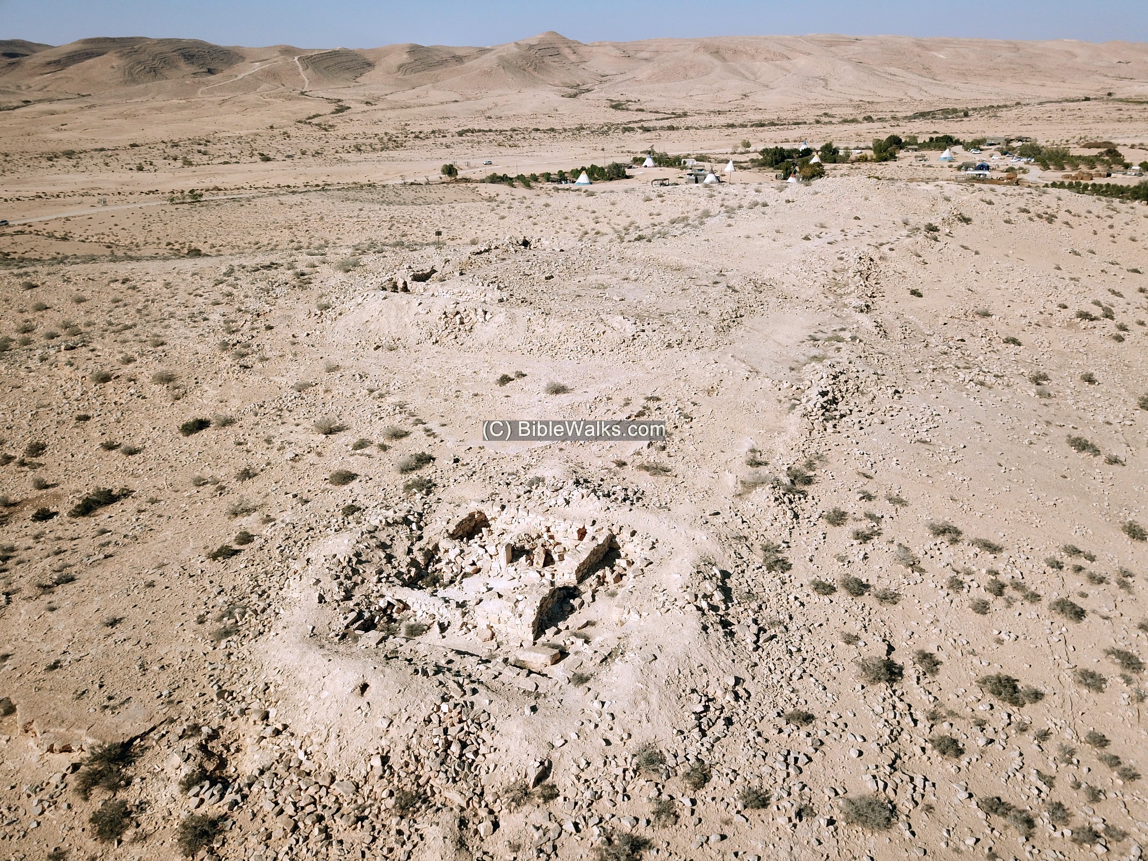
Hidden in this view, on the lower eastern foothills on the right, are remains of 10 residential houses, 3 of them were excavated:
- The northern structure is a ‘four-room’ house 8.6 x 10.50m, with Israelite II period remains.
- Another similar structure with same size was excavated 60m to its south.
- On the south-west side a third structure was exposed, 8.5 x 9.8m in area.
In the far background are modern farms, and behind them is the valley of Nahal Boker.
(b) The fortress:
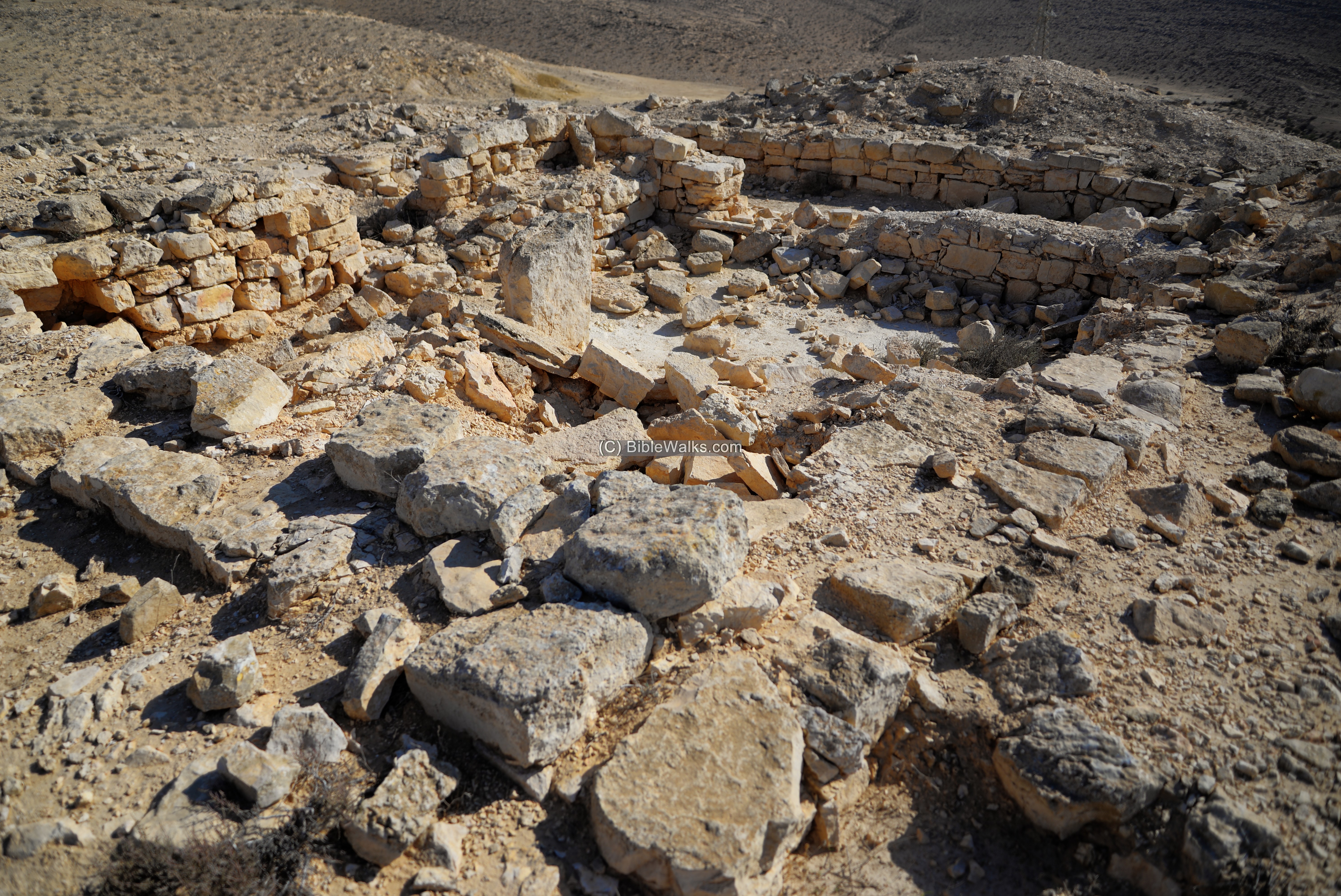
A fortress was built on a ridge overlooking the valley. It was constructed during the Iron Age II.
The fortress is square – 21m x 21m. Its plan is a large central courtyard surrounded by casemate rooms.
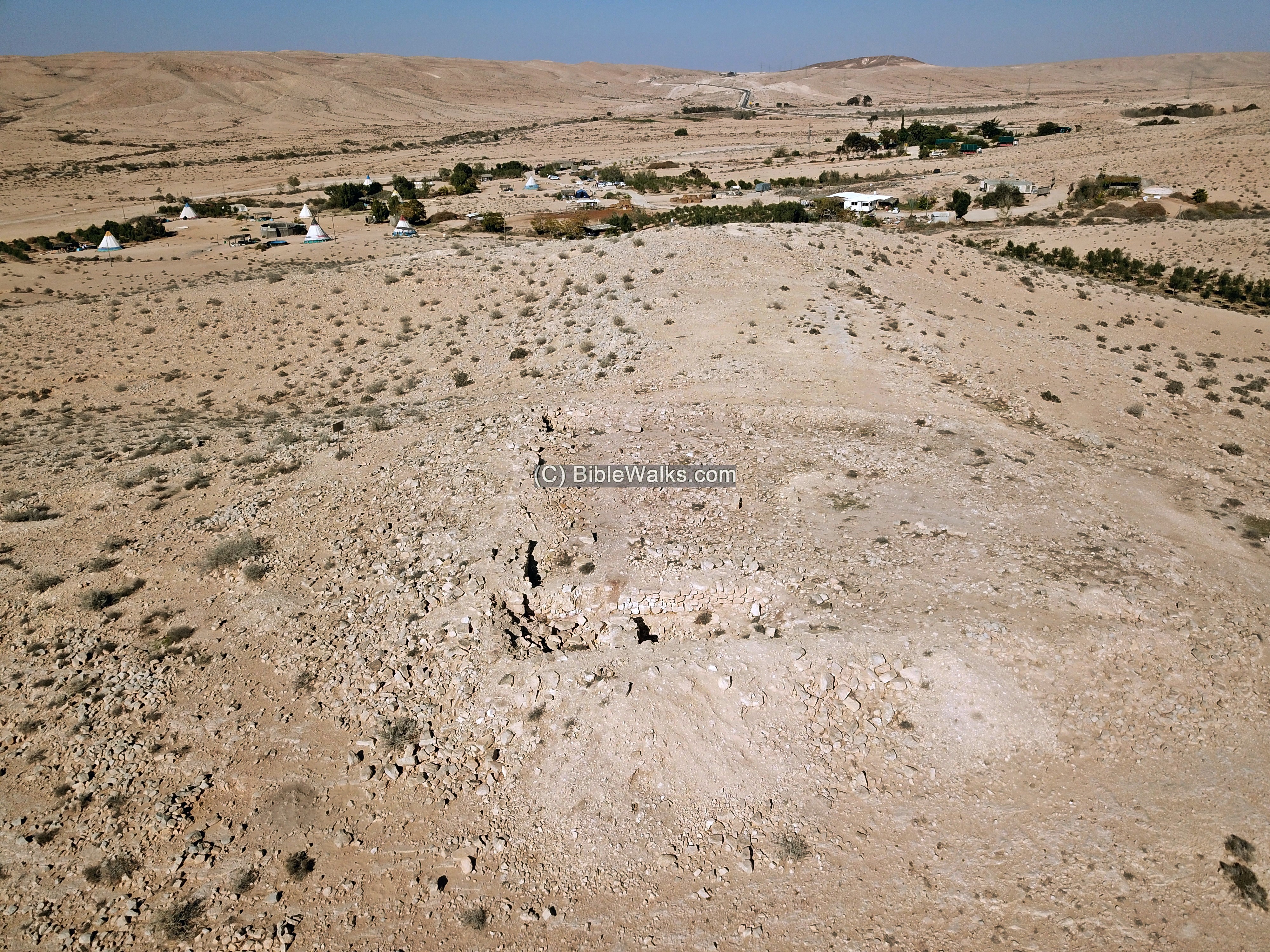
The archaeologists unearthed 2 casemate rooms on the south-western corner of the fortress. The ceramics in these rooms were dated to the later phase of occupation – the Nabatean period.

The walls are 0.8m wide and preserved to a height of 1m.
The majority of the fortress was not yet excavated.
(c) Commander’s house
A ruin near the fortress was named the “commander’s house’. Its function was based on the high quality of the construction, its location on the high point of the hill, and special details in its plan.
Similar “commander houses” were identified in other Israelite desert fortresses – Haro’eh, Mesorah – as well as in northern fortresses such as Tel Mizpah (Tell en-Nasbeh near Ramallah).

The structure is planned as a “four-room” house, a common plan of the Israelite period. It covers an area of 8.0m by 9.5m, with 0.7-0.6m wide walls. Ceramics were dated to the Nabatean period (upper layer) and the Israelite II period (lower layer, including a complete Negev type cooking bowl).
The following view is towards the north. The entrance is on the far right (east side), that opened to the eastern room (#15-16). From there, an opening led into a 3m wide central courtyard (#11-16). Two monolithic columns, 1m tall, stand in the northern side of the courtyard. A ramp on its south-east corner was the base of a staircase to its roof.
To the north of the courtyard is the northern room (#10-12), where thin layers of ash were found on the floor.
To the south of the courtyard is the southern room (#13), also with layer of ash on the floor. A column, seen here laying on the floor, separated this room with the entrance space.
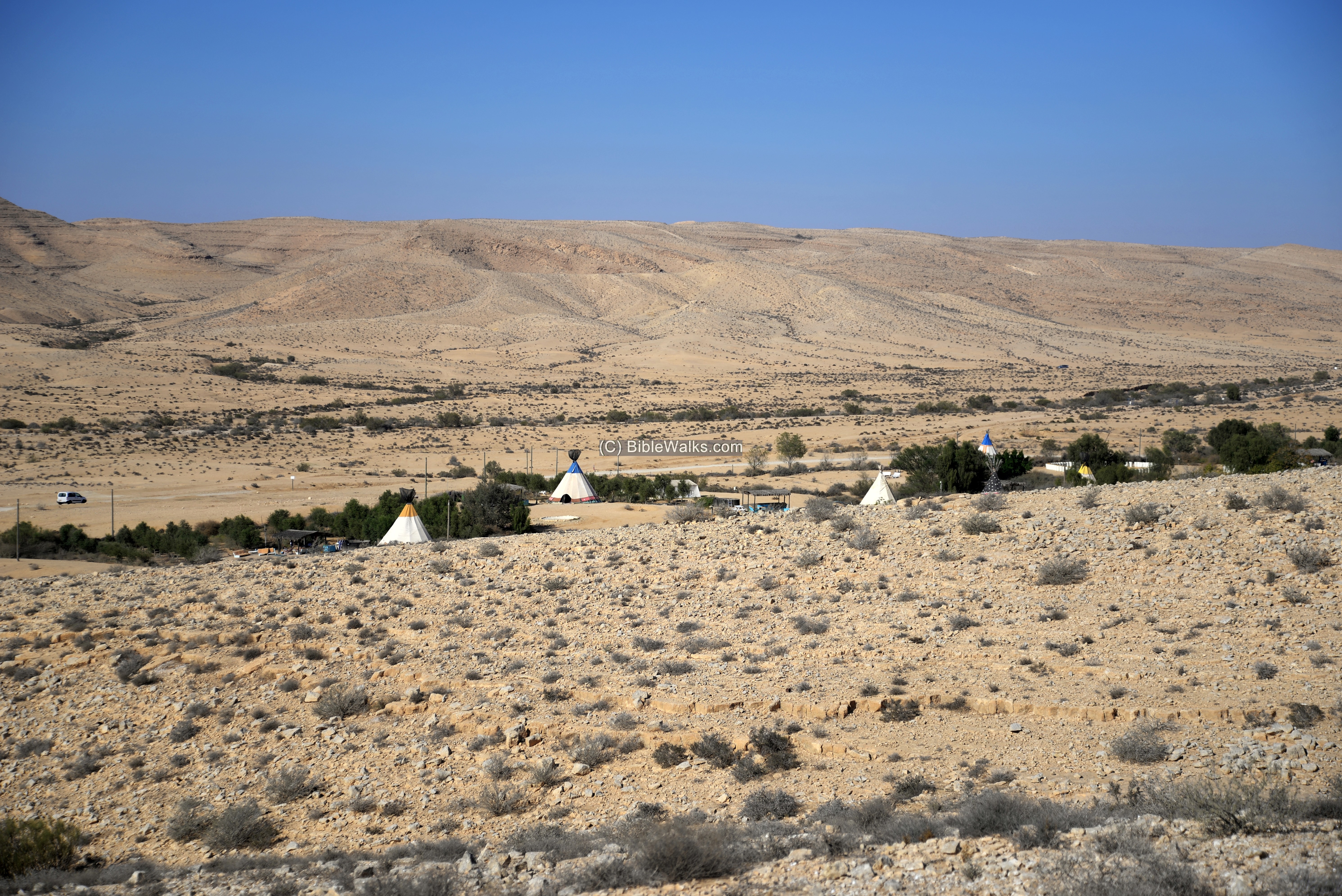
(d) The valley
The site is located on a low hill overlooking on the vast valley below it. In ancient times, until modern period, the valley was irrigated, crossed by dams and was farmed .
This photo is a view towards the west.
Through this valley the ancient route passed on its way west via the valley of Nahal HaBesor. The ancient route passed through the opening of the HaBesor valley seen here on the left side.

The next photo is a view towards the north, with a view of the modern farms. Several Indian tents, seen here between the trees, host guests in the Olive Hamidbar (desert olive) farm.
In the far background, on the hillside, is another Iron Age II fortress – Ramat Boker (also: Ezboah). Other fortresses of the same period can be seen from here – Har Boker (3km south west) and Metsad Ma’agura (5km south).
(e) Flight over the site:
![]() The following YouTube video shows a flight of a drone over the site.
The following YouTube video shows a flight of a drone over the site.
(f) Nearby sites
Another Iron Age IIa period fortress – Ramat Boker fortress – is located on the northern side of the valley, 1.2km to the north.
Etymology (behind the name):
- Sde Boker, Sede Boqer – Kibbutz, established 1952.Meaning (Hebrew): herding field.
- Ritma, Rithmah – May be based on a bush: Rotem. It was a station in Sinai in the travels of the Israelites during the exodus (Numbers 33: 18-19): “And they departed from Hazeroth, and pitched in Rithmah. And they departed from Rithmah, and pitched at Rimmonparez.”
Links and References:
* External links:
- Archaeological Survey of Israel – Map 167 (Sde Boker West) – site 73 – Horvat Ritma (Hebrew)
-
“Kh. Ritma / ח’ רתמה.” Hadashot Arkheologiyot / חדשות ארכיאולוגיות, לט, 1971, pp. 28–29. JSTOR, www.jstor.org/stable/23476961.
- Who built the Israelite fortresses in Negev heights? – Zeev Meshel, 1975 (Hebrew, pdf) – a thorough review of the site
- Zayit Hamidbar – Desert Olive Farm
- Sde Boker – Home page of the Kibbutz (Hebrew)
* Song:
![]() “Va-yiven Migdalim…” – Hebrew song by Dudayim, on King Uzziah – builder of desert towers and cisterns (2 Chronicles 26: 9-10)
“Va-yiven Migdalim…” – Hebrew song by Dudayim, on King Uzziah – builder of desert towers and cisterns (2 Chronicles 26: 9-10)
* Other Iron Age II desert fortresses in BibleWalks:
* Other Internal links:
- Lost city near Sde-Boker – nearby Byzantine period settlement
- BibleWalks YouTube channel – join!
BibleWalks.com – Search for the lost cities of the Bible
Horvat Ritma<<<—previous site—<<<All Sites>>>—Next Negev site—>>> Horvat Halukim
This page was last updated on June 6, 2021 (New site)
Sponsored links: