Ruins of a Israelite period desert fortress on the bank of Nahal Zin, near Mt. Eldad
Home > Sites > Negev > Mt Eldad fort
Contents:
Background
Location
History
Photos
* Aerial views
* The Fort
* Findings
* Flight Over
Etymology
Links
Overview:
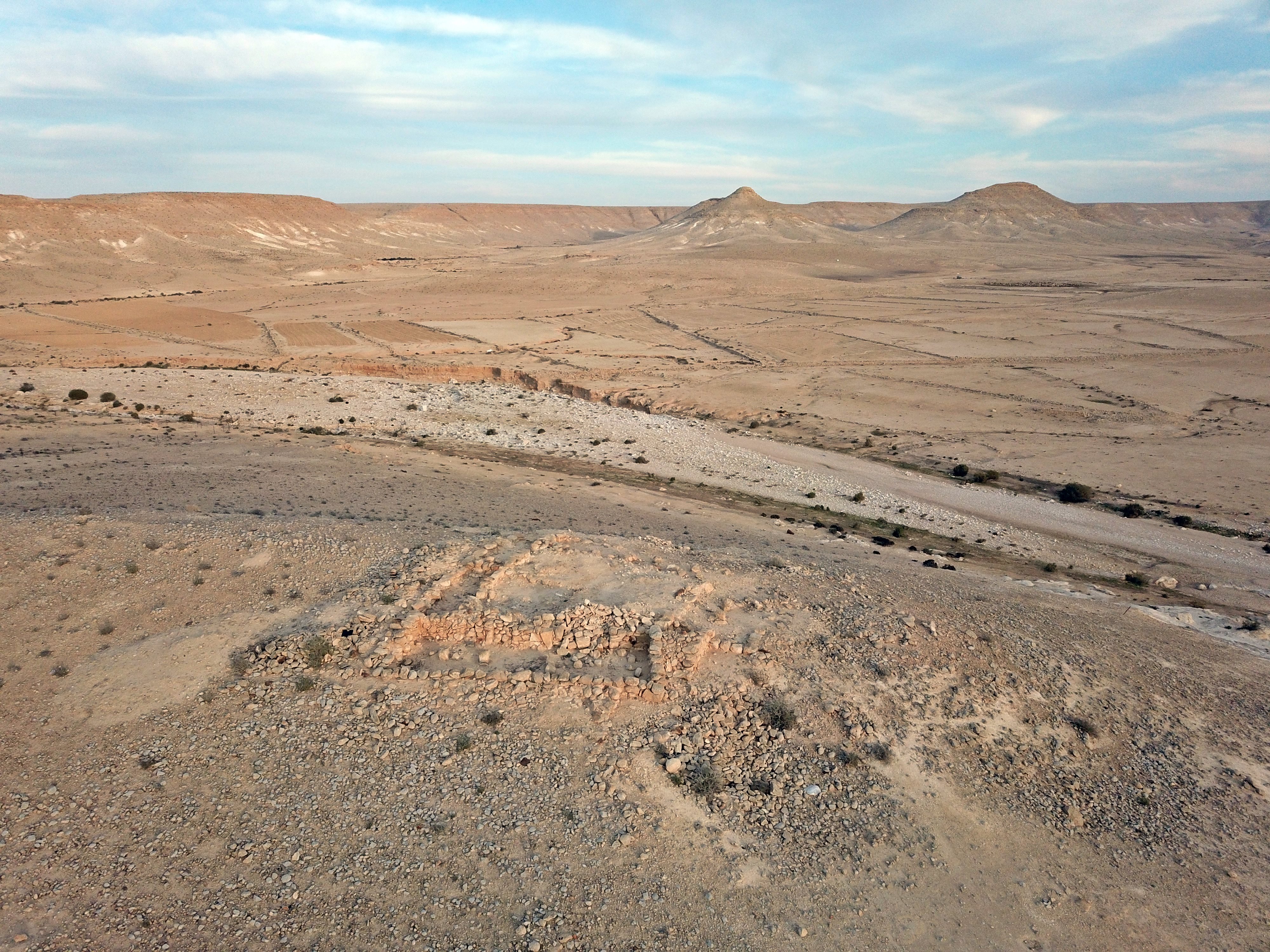
This small Iron Age fort is located on a small rocky hill, on the North-West bank of Nahal Zin, 2km south of Avdat National Park. It guarded the ancient route from Makhtesh Ramon towards the north and west.
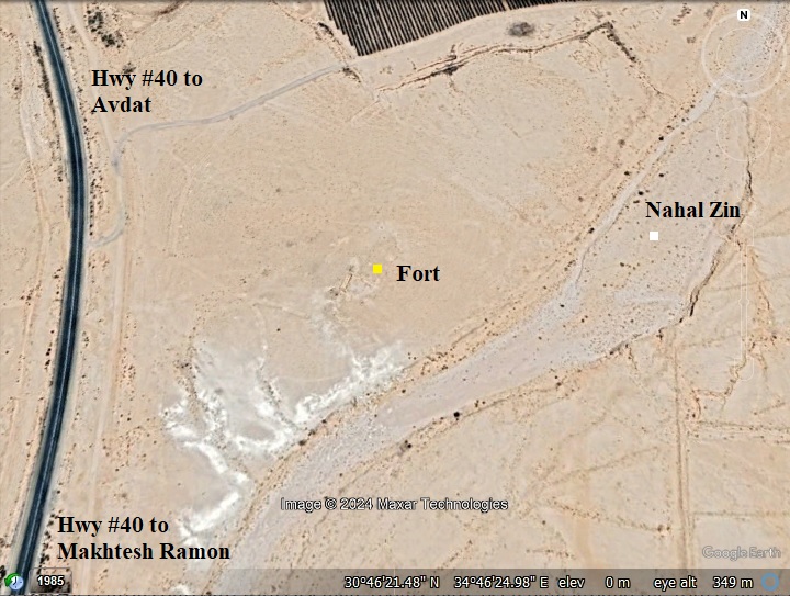
Location and Map:
The site is located on the east side of Highway #40, in the Ramat Negev desert area. It was built on a small hill on the bank of Nahal (Wadi) Zin.
Nahal Zin, normally a dry riverbed, is one of the significant wadis. It runs from the central Negev Highlands to the Arava Valley, cutting through the rugged and arid landscape of the Negev Desert. The wadi is characterized by steep cliffs, rocky formations, and occasional pools of water. Nahal Zin, is mentioned in biblical texts. The area has historical and cultural significance in the context of the Old Testament.
Mt. Eldad is a hill on the west side of the highway.
History:
-
Iron Age IIa period (1000-925 BC)
In the Negev area are over 40 fortresses of small to large sizes that were identified as “Israelite fortresses’ and dated to the Judean Kingdom period. The majority had common features – located near major trade routes, a plan of central courtyard with casemate rooms, have been built around the 10th century BC, and had small 4-room houses were built at their side.
The fortress near Mt Eldad is one of the small forts.
- Who built the desert fortresses?…
Who built this fortress, as well as others in the desert area? Scholars offer various identifications. Some relate their construction to the royal administration of the Judean Kings, such as David and Solomon (only the small forts), or to Jehoshafat (870-849 BC) and Uzziah (mid 8th century) for the large fortresses with towers.The fortresses offered protection on the major trade routes and established control and royal presence.
The Bible tells us about these desert constructions (2 Chronicles 26: 9-10):
“Moreover Uzziah … built towers in the desert, and digged many wells: for he had much cattle, both in the low country, and in the plains…”.
Other scholars, however, offered other identifications such as relating their construction to the actions of the desert tribes – whether Israelite or foreign tribes.
- Trade route:
One of the important trade routes, known as the Incense & Spice route during the Roman/Nabatean period, led from Petra (in Jordan), thru Makhtesh Ramon, passing the site and nearby Oboda (Avdat), and arriving to the port city of Gaza. A north bound route connected at Elusa to Beersheba and continued north.
The location of the fort is marked as a red square on the Biblical map below at the side of this route.
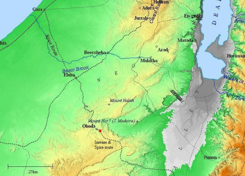
Map of the area around the site (marked by red square) – during the Roman/Byzantine periods (based on Bible Mapper 3.0)
-
Modern Period
A survey was conducted in 1955 and 1966. Excavations were conducted in 1984 and 2017.
The site is in an open public area, at the side of highway #40.
Photos:
(a) Aerial Views
A drone captured this view towards the east. The fort is located on a small hill on the north west bank of Nahal Zin. The dry riverbed of Zin is seen here behind the fort. In the far background are pointed hills – Meidad cone-shaped hill on the north side and Mt. Meidad on the south side.
Click on the photos to view in higher resolution…
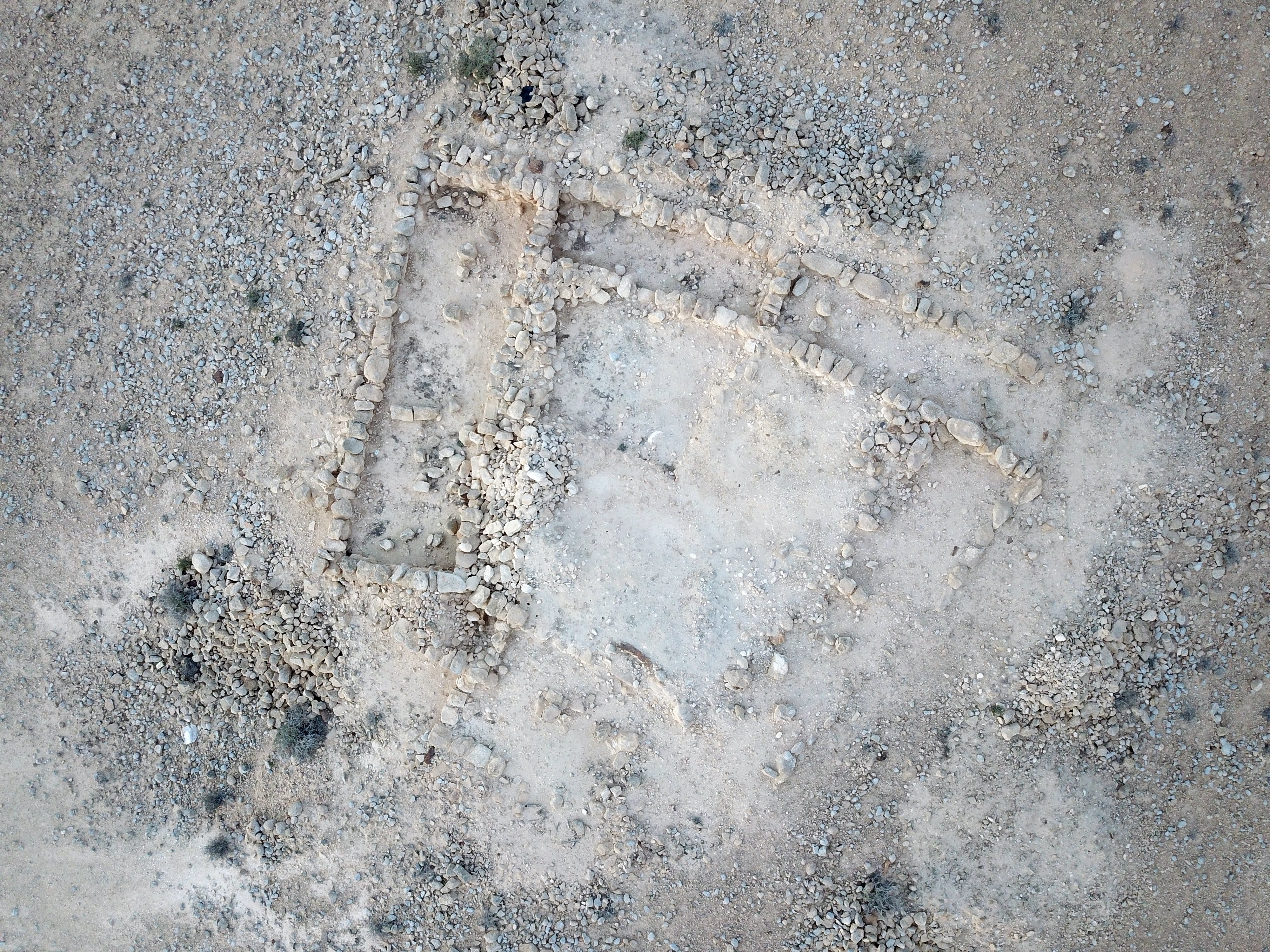
An vertical view of the fort is seen below. The rectangular-trapezoidal shaped fort covers an area of 14m by 18m.
(b) The Fort
The fort consists of an entrance room on the south side, and 5 casemate chambers arranged around an inner courtyard.
The archaeologists numbered the rooms and the sub areas inside the courtyard as L114 thru L120, as shown in the following illustration.
The following photos show a closer view of the rooms:
- L116 casemate room:
On the west side of the fortress is one of the 5 casemate rooms, labeled as “L116”. It was constructed by 2 long parallel walls and two shorted walls. The walls were made of medium sized limestone blocks, with smaller stones filling in the gaps. The floor is made of dirt. This room connected to the inner side of the fort via an opening to the L120 section of the courtyard.
This is a view from the north west. Only the bases of the walls were found.
Notice the retaining pillars in the center of the room that supported the roof. It was probably made of palm leaves spread over wood planks.
Below is another view is from the south west.
A closer view of the south side of the room. This wall was labeled W51.

Casemate design: Iron Age fortresses in Israel were often equipped with casemate walls, which incorporated casemate rooms. These fortifications were prominent during the Iron Age (1200 BC to 586 BC) and served defensive purposes for the protection of cities, military garrisons, and important sites. The casemate walls featured a series of interconnected chambers or rooms along the inner face of the wall.
The casemate rooms in Iron Age fortresses served various functions:
- Living Quarters: Some casemate rooms were likely used as living quarters for soldiers or residents of the fortress. These rooms provided shelter and protection within the thick walls of the fortress.
- Storage: Casemate rooms were suitable for storage of supplies, weaponry, and other essential items. The secure and protected environment offered by the casemate walls made them ideal for storing provisions.
- Defensive Positions: Soldiers stationed within the casemate rooms could use openings or embrasures in the walls to observe and defend against potential attackers. They could shoot arrows, throw spears, or use slings from these defensive positions.
- Strategic Placement: Casemate walls with rooms strategically positioned along the defensive perimeter of a fortress helped strengthen the overall structure. The interconnected nature of the casemates allowed defenders to move within the walls and respond to threats from different directions.
- L118 casemate room:
Another casemate room is on the north east side of the fort. This is a view of the room from the east side. It is adjacent to another casemate room – L117.
Another view of the room, from the west side:
- Courtyard:
The inner courtyard is 9m by 11m in area. It is entered from the entrance room on the south side, and connects to all of the casemate rooms around it. The archaeologists labels each one of the quadrants (L114, L115, L119, L120).
On the western quadrants (L119-L120) the surface was mixed with ash, apparently a habitation level. Black spots are seen on that side, perhaps the mixed soil that were reported by the archaeologists.
- Krater:
On the south west quadrant, L119, the archaeologists found an intact krater in situ.
A krater refers to a type of large, ancient vessel used for mixing wine and water during the Iron Age. The term “krater” comes from ancient Greek and refers to a wide, shallow bowl or basin with handles on either side. These vessels were often made from ceramic materials and decorated with intricate designs or motifs. Kraters were commonly used in various ancient cultures for mixing and serving liquids, particularly in communal settings such as feasts or symposia.
The krater is red-slipped with vertical burnishing.
Red-slipped refers to a pottery or ceramic surface treatment technique where a layer of red clay, or slip, is applied to the surface of the vessel before firing. The term “slip” refers to a liquid mixture of clay and water.
Vertical burnishing is a pottery technique involving the smoothing and polishing of the surface of a vessel in a vertical direction. This process is typically done before firing the pottery, and it contributes to both the aesthetics and functionality of the final piece. Burnishing is a method used to achieve a glossy, polished surface on pottery without the use of glaze.
Forty grape pips were found scattered near and some were found inside the krater. They were dated by radiometric analysis to the 11-10th century BC.
(c) Findings:
- Ceramic survey
The archaeologists unearthed ceramic tools locally made, dated them to the Iron Age IIa (11th-10th century BC). Forty grapes were found in an intact krater, and radiometric analysis also dated them to the Iron Age IIa.
- Our visit:
There are ceramics fragments scattered around the site, dated to the Iron Age. We did not see any substantial pottery lying around. However, during our short visit we saw one stone base of an installation on the east side of the walled fort.
On the western foothills we saw a flintstone blade. Its tip seems to be missing.
A round flint stone ball was also lying near the east side of the fort. It is 7cm in diameter. It may have served as a sling stone.
Round sling stones were commonly used as projectiles in ancient warfare during the Iron Age in the Levant. These sling stones were typically made of various materials such as clay, flint, lead, or other dense materials. The sling, a simple yet effective projectile weapon, involved swinging a sling around in a circular motion and releasing one end to propel the stone towards the target.
Sling stones served as ammunition for slings, which were widely used by infantry in ancient armies. The Levant witnessed numerous conflicts and battles during the Iron Age. Slingers were skilled warriors who could launch these stones with considerable accuracy and force, making them valuable assets on the battlefield.
(d) Flight over the site:
![]() The following YouTube video shows a flight of a drone over the site. It starts from the west side above the highway, then turns around the fort.
The following YouTube video shows a flight of a drone over the site. It starts from the west side above the highway, then turns around the fort.
Etymology (behind the name):
- Sde Boker, Sede Boqer – Kibbutz, established 1952.Meaning (Hebrew): herding field. The Hebrew name is based on the Arabic name of Mt. Har Boker – Shajarat el Baqqar – as appears on the British map of 1946.
- Mt. Eldad fort – The site’s name is based on the nearby Mount Eldad on the other side of the highway.
Links and References:
* External links:
- Zin, Mt Eldad fort – Hadashot-esi report V 131 2019
- Who built the Israelite fortresses in Negev heights? – Zeev Meshel, 1975 (Hebrew, pdf) – a thorough review of the site
- Sde Boker – Home page of the Kibbutz (Hebrew)
* Song:
![]() “Va-yiven Migdalim…” – Hebrew song by Dudayim, on King Uzziah – builder of desert towers and cisterns (2 Chronicles 26: 9-10)
“Va-yiven Migdalim…” – Hebrew song by Dudayim, on King Uzziah – builder of desert towers and cisterns (2 Chronicles 26: 9-10)
* Other Iron Age II desert fortresses in BibleWalks:
- Ramat-Boker fortress nearby site
- Horvat Ritma nearby site
- Beerotayim near Nitzana
* Other Internal links:
- Lost city near Sde-Boker – nearby Byzantine period settlement
- BibleWalks YouTube channel – join!
BibleWalks.com – Search for the lost cities of the Bible
Horvat Halukim<<<—previous site—<<<All Sites>>>—Next Negev site—>>> Tel Be’er Sheva
This page was last updated on Feb 27, 2024 (New site)
Sponsored links: