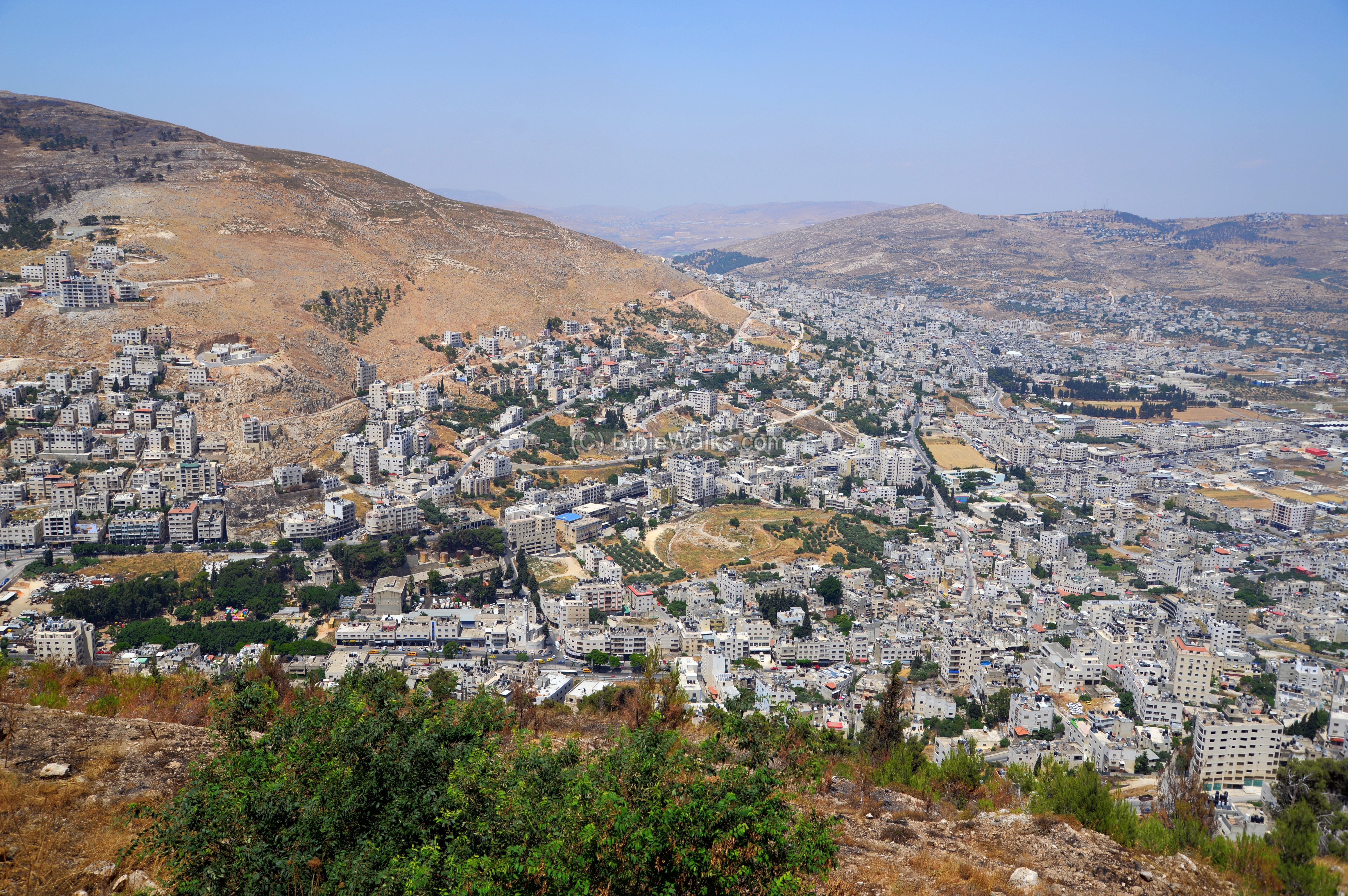
A lookout point adjacent to Tell er-Ras on Mt. Gerizim, with great views of Tel Shechem, modern city of Nablus, and the tomb of Joseph.
* Site of the Month Sep 2020 *
Home > Sites > Samaria > Mt. Gerizim > Joseph lookout
Contents:
Overview
Map
History
Photos
* Aerial views
* Tell a-Ras
* Tel Shechem
* Tomb of Joseph
* Other views
Biblical References
Etymology
Links
Overview:
On the north side of Mt. Gerizim are remains of a Roman temple that overlooks Shechem and Mt. Ebal. From the lookout point are great views of the area, including the Biblical mound of Tel Shechem and the tomb of the Biblical Patriarch Joseph. Joshua 24:32: “And the bones of Joseph, which the children of Israel brought up out of Egypt, buried they in Shechem…”.
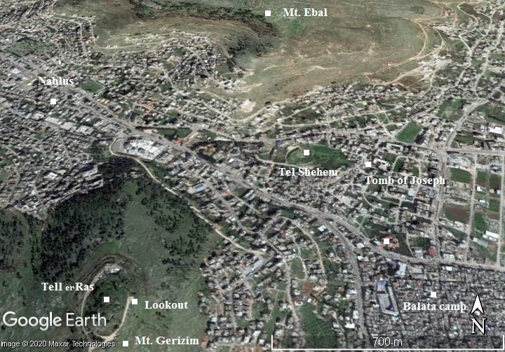
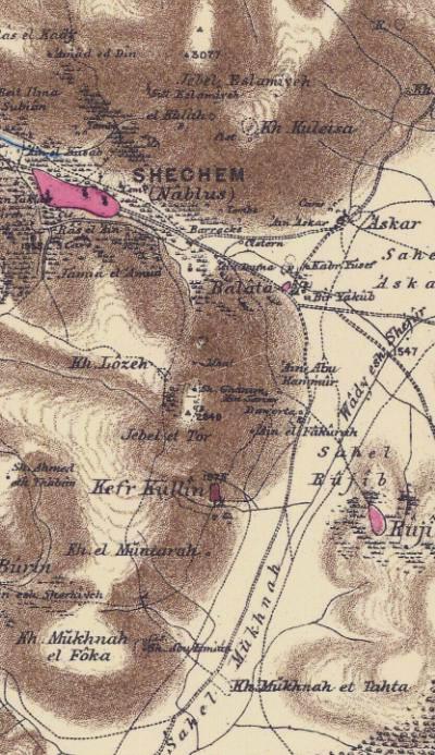
Map / Aerial View:
An aerial map is shown here, indicating the major points of interest around the site. The lookout can be reached from Kiryat Luza – the Samaritan village on mount Gerizim. It is located on the east side of Tell er-Ras (“hill-top”) – a mound with ruins of a Roman temple. The hill is situated at 800m above sea level, 250m above the city.
Due north, in the valley, are the ruins of Biblical city of Tel Shechem. On its east side is the traditional tomb of Joseph. The Roman and Crusaders cities of Shechem are located farther west, inside the modern Arab city of Nablus.
History:
- Burial of Joseph
According to a biblical story from the book of Genesis, Joseph, one of the twelve sons of Jacob, was sold into slavery by his jealous brothers and ended up in Egypt. Through a series of events, Joseph rose to a position of power and became the second-in-command to the Pharaoh.
In Genesis 50:24-25, Joseph instructed his brothers to take his bones with them when they eventually leave Egypt and return to the land of Canaan. This was because Joseph wanted to be buried in the same place where his forefathers were buried. When the Israelites finally left Egypt and entered the Promised Land, they carried Joseph’s bones with them and buried them in Shechem, in a plot of land that Jacob had bought. Joshua 24:32:
“And the bones of Joseph, which the children of Israel brought up out of Egypt, buried they in Shechem…”.
According to the Bible, Joseph’s bones were buried in a plot of land that Jacob had bought from the sons of Hamor, the father of Shechem, for a hundred pieces of silver (Genesis 33:18-20). This plot of land was located in Shechem, which is now present-day Nablus in Samaria.
The exact location of Joseph’s burial place is not specified in the Bible, but according to tradition, his tomb is located in a site called “Joseph’s Tomb,” which is located in the eastern outskirts of Nablus. The site has been venerated by Jews, Samaritans, Christians, and Muslims for centuries, and has been the source of numerous conflicts between different religious and political groups.
Currently, the tomb is under the control of the Palestinian Authority, and access to the site is restricted due to ongoing political tensions and security concerns. However, during certain Jewish holidays, Jewish worshippers are granted permission to visit the site under Israeli military protection.
- Shechem in earlier periods
Shechem was established 4000 years ago. It was one of the most important cities in this region during the Biblical periods. Ancient Shechem was located 2km east of the Roman/Crusaders city, situated on a strategic junction of roads, nested between Mt. Gerizim and Mt. Ebal, in the center of the fertile Michmethat valley with abundant of spring waters. Its ruins are located on Tel Shechem, also known as Tel Balata (Balatah).
The archaeologists identified 24 layers in the course of the settlement of the city. It started in the Chalcolithic period (level XXIV) and Early Bronze period (XXIII), and became a major fortified city in Middle Bronze period II (level XXII). The city continued though the Iron Age Ia (XI) and Iron Age II (X) when it was destroyed by the Assyrian Shishak. The now smaller city continued until, and including, the Hellenistic periods (layers IV to I), then abandoned and relocated westwards.
-
Roman/Byzantine Period – (1st – 7th century AD)
Shechem was annexed in 6AD to the Roman Province of Syria. In 72AD, following the destruction of Jerusalem, a new city was established 2KM west of Tel Shechem, named Neopolis – the “new City”. The Romans built this pagan city as a lesson learnt from the Jewish Great Revolt, and in order to quell the desire of the Samaritans to rebuild their temple city on Mt. Gerizim as it was forbidden by the Romans.
In the 2nd century, during the reign of Antoninus Pius, bronze coins minted in Neapolis show the sanctuary of Zeus on Mount Gerizim and the stairs ascending from the valley to the mountain. More such coins were minted between 138 to 253.
Below – a coin minted in 247-249 of Philip II (courtesy of zuzimcoins.com). Obverse: Laureate, draped head of Philip surrounded by inscription; Reverse: Eagle with spread wings supporting Mount Gerizim with twin peaks surmounted by Temple and altar. Steps lead to Temple with colonnaded below, inscription above eagle and around. Writing: NEAPOLI NEOCORO COL. (Neocoro – a dignity granted to certain cities which had built temples to the Emperor).
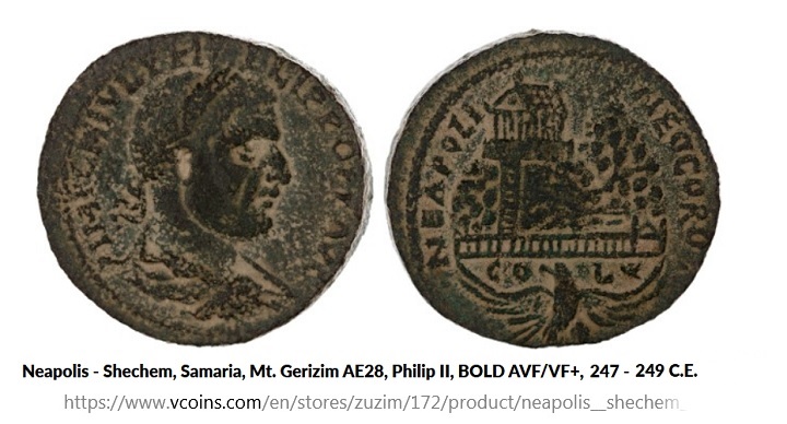
The coins have a detailed depiction of the ancient sanctuary on Mount Gerizim (now Tell er-Ras). The temple is shown with 4 columns in the front, with columns on all its sides (peripteral), and situated on a platform. From the temple a long straight staircase descends down to the city. Excavations on the mound confirmed the existence and structure of the temple, and determined it was built over an earlier structure.
The staircase is illustrated on these series of coins and medals. According to Epiphanius of the 2nd century, the marble staircase had more than 1,500 steps. Traces of this staircase were found in the excavations.
- Ottoman Period – (1516-1918 A.D.)
The area was examined in the Palestine Exploration Foundation (PEF) survey (1866-1877) by Wilson, Conder and Kitchener. The authors wrote about Mt Gerizim and the area in the Survey of Western Palestine – SWP (Vol 2 pp. 187-190).
Part of map Sheet 11 of Survey of Western Palestine, by Conder and Kitchener, 1872-1877.
(Published 1880, reprinted by LifeintheHolyLand.com)
Their description of the ascent to Mt. Gerizim is as follows (Vol 2, Sheet XI, p. 205):
“In the time of Josephus the name of Shechem had already been changed to that of
Flavia Neapolis, after the Flavian family, to which Vespasian belonged. It was also called
by the people Mabortha, a name of which no trace was found by the surveyors. Medals of
Antoninus Pius exist, struck at Neapolis, which represent the temple of Gerizim approached
by great stairs cut in the mountain-side”.
A drawing, dated 1890-1900, shows Shechem (Nablus) and Mt. Gerizim, as seen from the north. The staircase, now dismantled, descended during the Roman/Byzantine period along the left ridge.

Views of the Holy Land in the Photochrom print collection, Library of Congress
- Modern period
Joseph lookout is open to the public. It can be reached by a road descending from the Samaritan village of Kiryat Luza, passing near the famous Samaritan sesame factory. The lookout offers great views and is a recommended stop after visiting the national park on top of Mt. Gerizim.
Photos:
(a) Aerial view
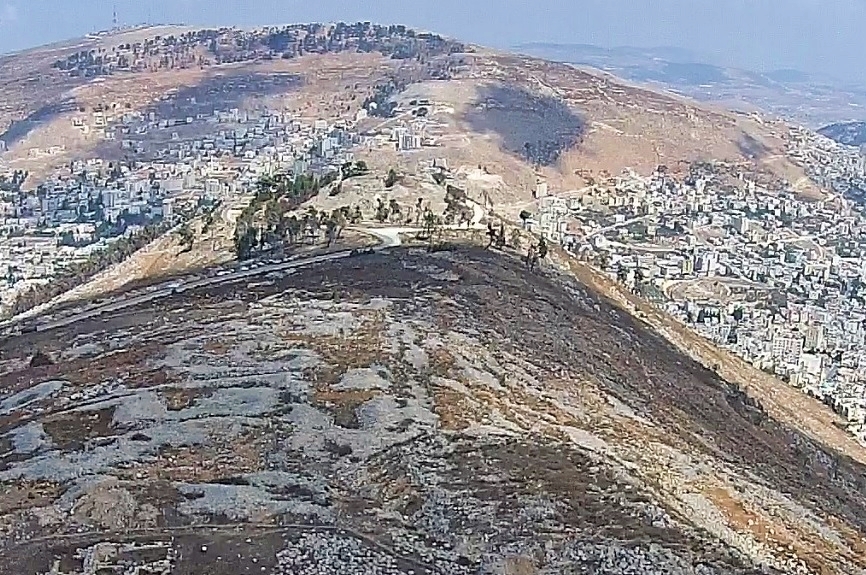
A drone view was taken above Mt. Gerizim, focusing on its northern foothills. Mt. Ebal is in the far background. On the far left is the city of Nablus. On the far right is the villages of Balata and Askar.
The round mound at the edge of the hill is Tel er-Ras, where ruins of a Roman/Byzantine are located. At its right side is Joseph lookout.
(b) Tell a-Ras
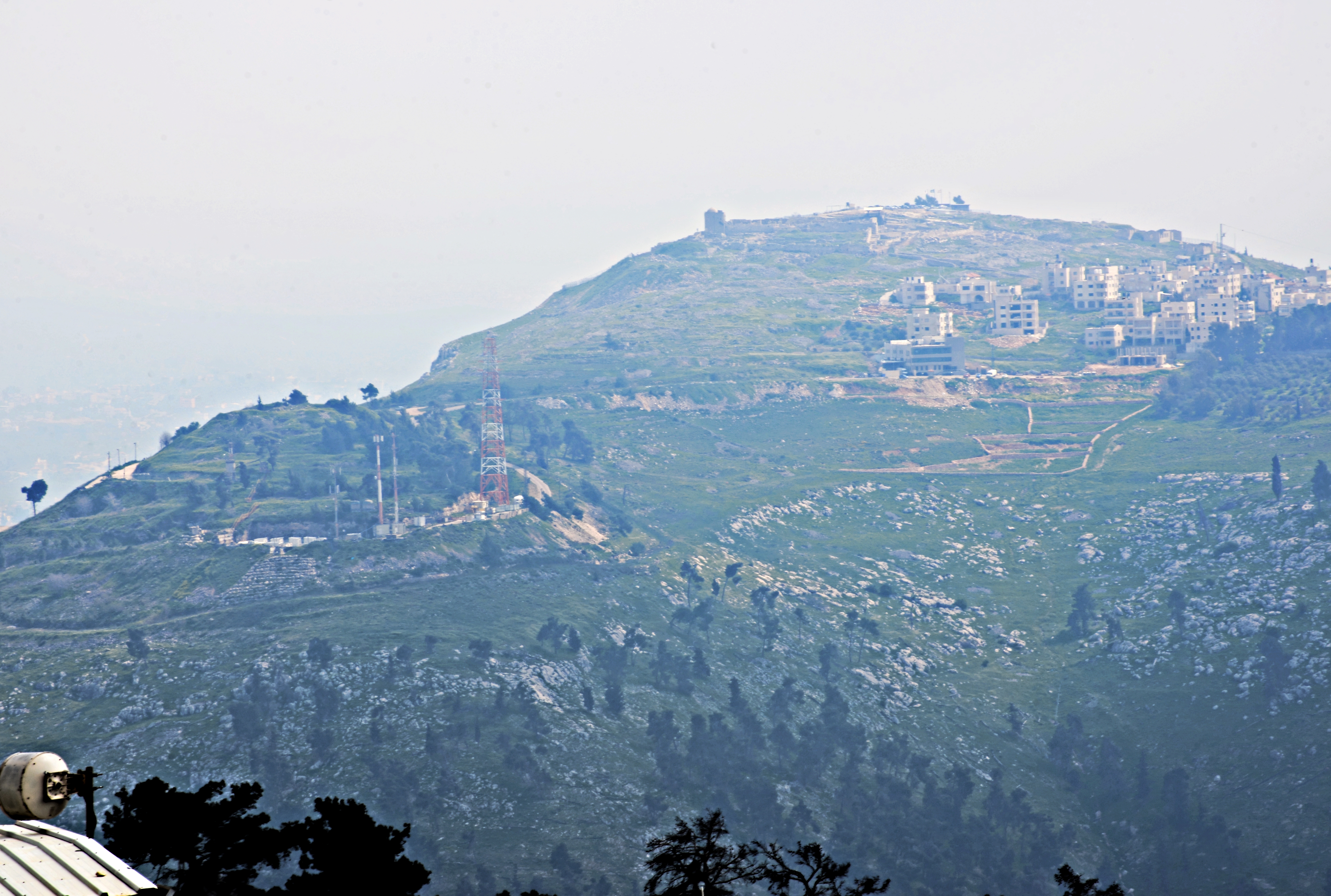
On Tell er-Ras (“the mound of the hilltop”) are remains of the Roman period sanctuary of Zeus, built by Hadrian in the 2nd century AD. The conical mound measures 120m long by 80m wide. The area south of the mound, and the ancient staircase that led to it from Shechem, is occupied by an IDF post and therefore not accessible.
The mound is seen in this photo captured from the national park at Mt. Gerizim.
A view from Mt. Ebal shows Tell a-Ras from the north side. It is seen here on the left side, under the Samaritan village on Mt. Gerizim.
A description of Tel a-Ras appears in the 1873 PEF quarterly statement VIII. Wilson wrote there (p. 69):
“At the extremity of the arm mentioned above as running northwards from the castle is a mound, partly artificial, and isolated from the ridge by a deep ditch. There are traces of steps on the four sides leading to the summit of the mound, which was occupied by a building fifty-three feet square, having walls of great thickness. Some excavations were made, but with the exception of a few Roman coins nothing of interest was found. Below the mound on the north are some excavations in the rock, apparently for holding water”.
A closer view of the mound is next.
Click on the photos to view in higher resolution…
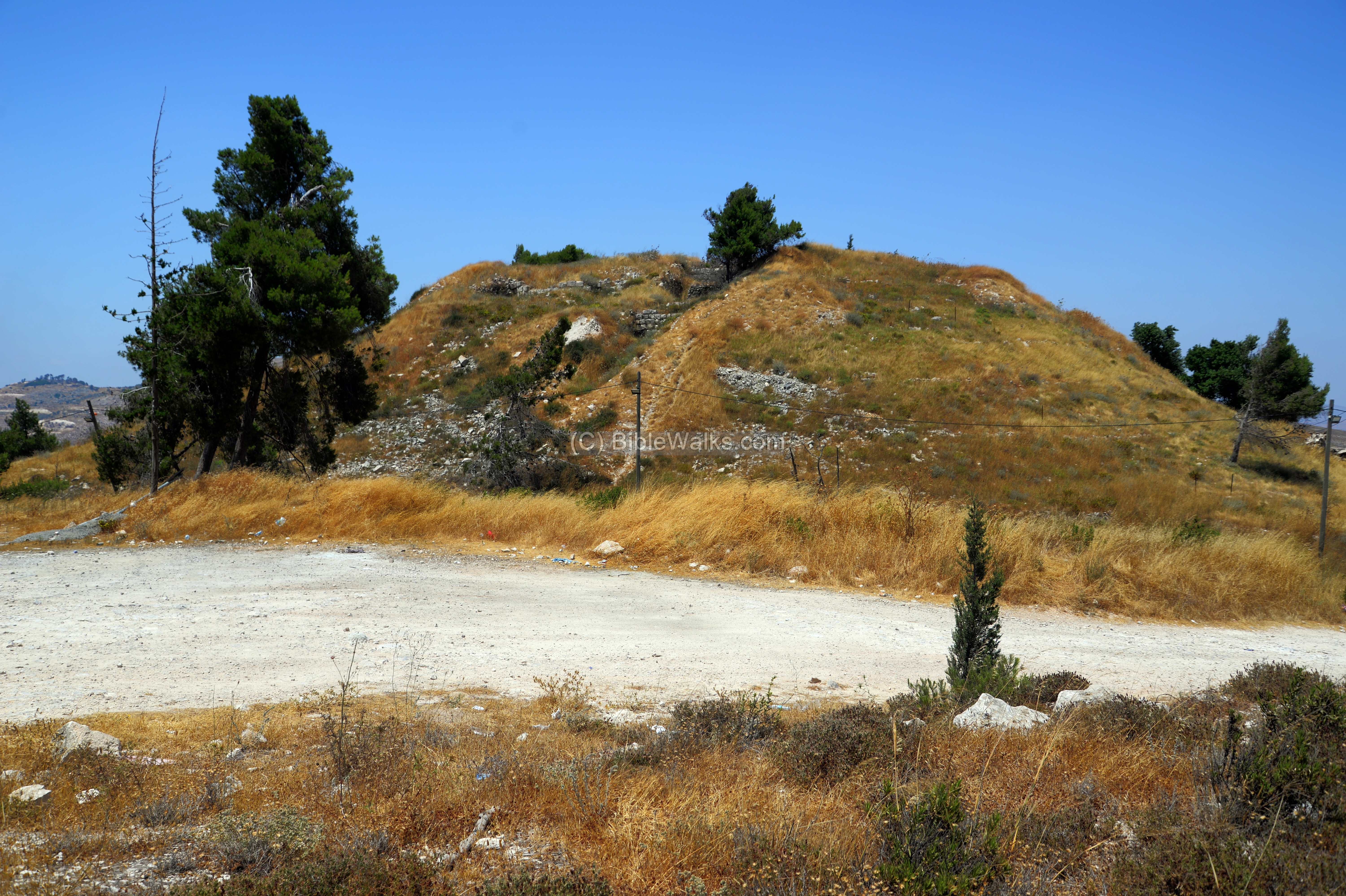
The trees on the northern foothills were planted by the British, as they asserted that Mt. Gerizim should be seen fertile as in the Bible. Unfortunately, the trees damaged the remains of the ancient staircase that ascended to the city in the valley.
Few remains of its walls are visible on the eastern side, as in the next photo taken near the Joseph lookout.

Archaeological excavations of the temple were conducted in 1964 and 1964. Sadly, most of the architectural remains were robbed and reused in buildings across Shechem. Nevertheless, the archaeologists revealed 2 stages in the constructions in this mound. The structure started from a 20m square base over the bedrock. This base, designated as building (‘B’), had 18 or more courses raising 8m. It was an earlier temple, probably Samaritan, dated to the Hellenistic period, based on the sherds found on this building. After it was leveled, it served as the base for the Roman structure.
Above it was a larger building ‘A’, a platform covering an area 65m long x 44m. It was standing 7m above the area. The temple stood behind a front courtyard 25m long by 44m wide.
An illustration of the temple is shown here, with the grand staircase leading down to the Roman city.
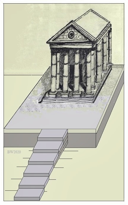
Illustration of the sanctuary of Zeus on Tell er-Ras
The Roman colonnaded building, standing over this huge platform, was fully identified with the Roman temple built by Hadrian and dedicated to Zeus. In its remains the excavators unearthed a section of a pedestal, with an inscription dedicating to Zeus Olympius. A section of a sundial was also unearthed, which may have stood in the courtyard in front of the temple.
Six sections of the staircase were also identified downhill, aligned along a line from the temple to the small mosque of Rijal el-‘Amud (“the column”) on the south eastern side of Nablus.
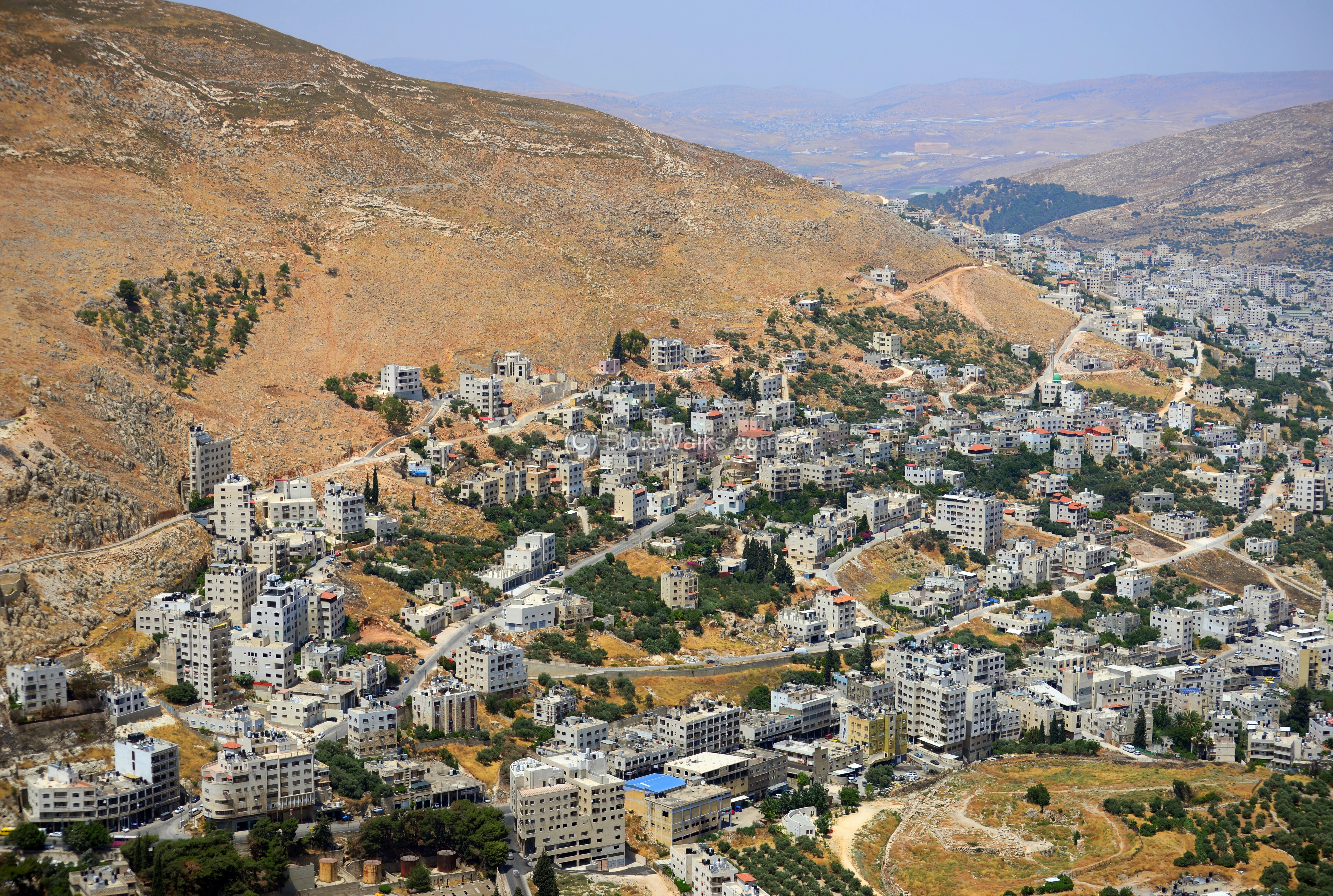
(c) Tel Shechem
From Tell er-Ras is a great view of the Biblical Tel Shechem.
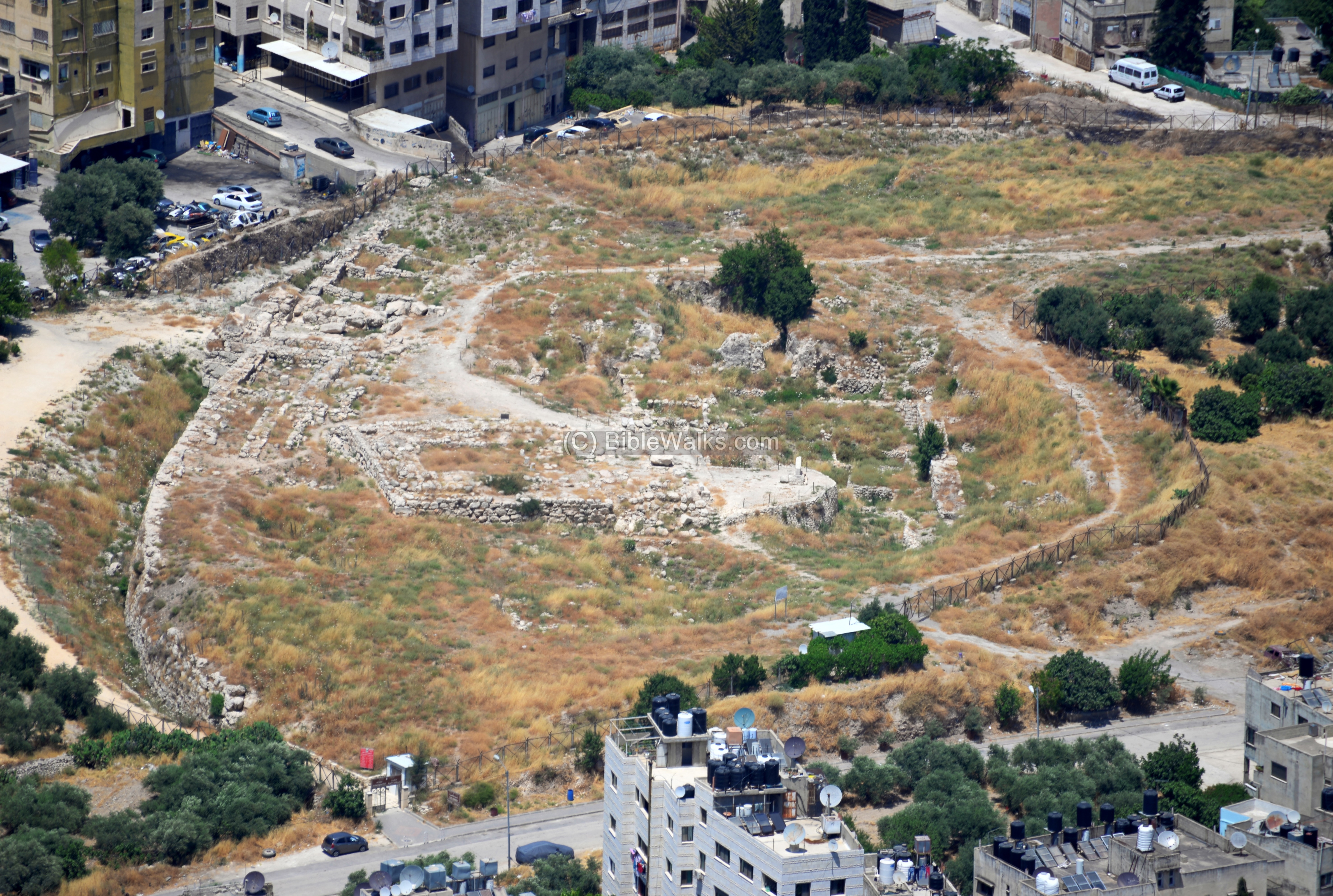
The remains of Tel Shechem are located in Tell Balata (Balatah), a mound named after the town that occupies the valley, and visible from the lookout. Note that the large refugee camp of Balata is located south east of the mound.
This visible section of the mound shows the circular wall that surrounded the city. Shechem covered an area of 40-50 dunam, towering 21m above the original height of the valley. It had two fortified gates, with the north-west gate seen here on the upper left side of the wall. The gate was protected by two towers on both sides. On the wall (“A”) south to this massive gate was a temple (named 7300) and a palace. A large rectangular structure is nearby – the Canaanite “tower temple”, which was dated to the Middle Bronze II. The water supply to the city came from a nearby spring, one of many in the valley of Shechem.
Excavations in Tel Shechem were conducted in 1913-1914 (E. Selin), 1926-1927 (E. Selin), 1928-1931 (G. Walter), 1932-1934 (E. Salin). Unfortunately, most of the excavation findings and notes were destroyed in Berlin in WW2. New excavations resumed in 1956-1964 (G.E.Wright) and 1966-1973.
Below – An old photo of the mound (captured 1920 to 1933), during the excavations, with the foothills of Mt. Gerizim in the background.
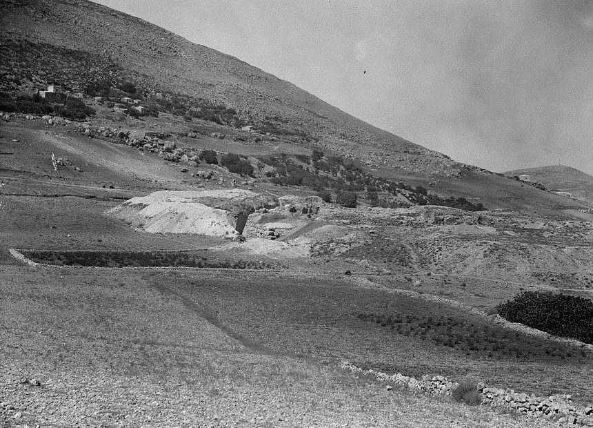
American colony photographers, from Library of Congress Matson collection
(d) Tomb of Joseph
According to the Bible, Joseph was buried in the tomb that was purchased by his father in a field “before” the city of Shechem.
Joshua 24:32: “And the bones of Joseph, which the children of Israel brought up out of Egypt, buried they in Shechem…”.
An old photo of the tomb, from the north side, was captured between 1898 and 1914. There were no buildings around it at that time, in contrary to the congested area around it today. Mt. Gerizim is seen in the background, with the shrine on its top.

American colony photographers, from Library of Congress Matson collection
Below is an earlier illustration of the entrance to the tomb was drawn by David Roberts in 1839.
The 19th century SWP description of the tomb of Joseph is (Volume 2, Sheet XI, pp. 94-95):
“Kabr Yusef, Joseph’s Tomb (M n).—The building is quite modern. An open courtyard surrounds the tomb, with plastered walls 10 feet high. This enclosure was rebuilt by Consul Rogers, as stated in the following inscription on the south wall :
‘ This building surrounding and covering the tomb of the Patriarch Joseph was entirely rebuilt at the expense of Mr. E. T. Rogers, H.B.M.’s Consul at Damascus, January, 1868.’ The tomb is not in line with the walls of the courtyard, which have a bearing of 202°, nor is it in the middle of the enclosure, being nearest to the west wall. The tomb itself is rudely shaped, with a ridge along its length at the top, and has a bearing 227°. It is 3 feet high, 6 feet long, and 4 feet broad. There is a sort of pillar, also covered with plaster, at the head, and another at the foot of the tomb, with a cup-shaped hollow in the top of each, where oil-lamps are lighted and incense burnt by the Jews and the Samaritans.
The pillars are 2 1 inches in diameter. That on the south 2 feet 7 inches high ; that on the north 3 feet 9 inches. The courtyard measures 18 feet 7 inches square inside. The walls are 1 foot 9 inches thick. On the south is a Mihrab, 2 feet diameter, and 6 feet 3 inches high. Above it are two Hebrew inscriptions, both apparently modern ; a passage in the floor of the enclosure, 4 feet wide, has a level 6 inches lower than the side Diwans or raised platforms.
The entrance to the courtyard is from the north, through the ruin of a little square building, with a dome measuring about 22 feet either way or equal to the new courtyard. There is a vine on the north-east angle of the courtyard. – Visited July, 1872; June, 1875; May, 1881″.

From Library of Congress collection
Back to modern days:
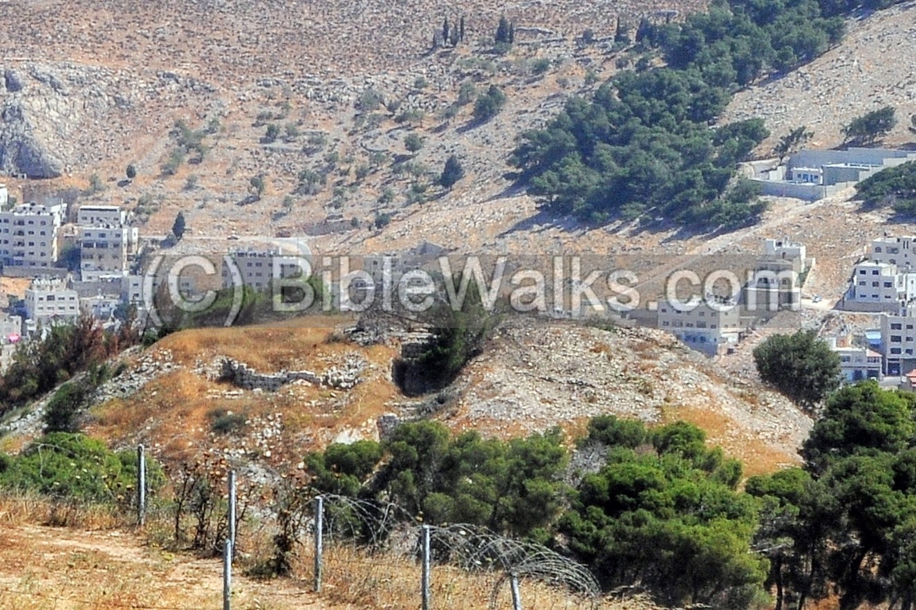
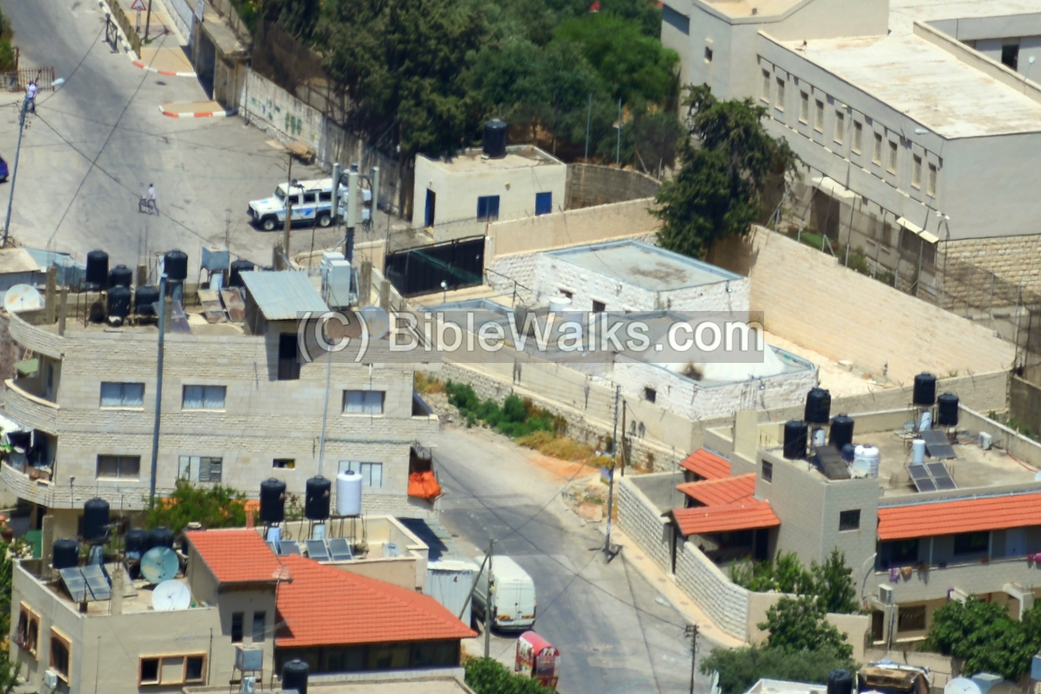
The structure of the tomb of Joseph is located near the eastern foothills of Tel Shechem. The open field from the previous century is now gone. The tomb structure is confined inside a small area squeezed among modern buildings.

Due to security reasons, Jews are not secure to visit the tomb. Only in few cases, with heavy protection, the army allows these visits. The holy tomb is a frequent clashing place between religious Jews who occasionally come to pray here, and the Arab community around it. Therefore, the best and safe place to see the tomb is from the lookout on the side of Tel er-Ras.
Below is a larger view of the compound.
(e) Other views
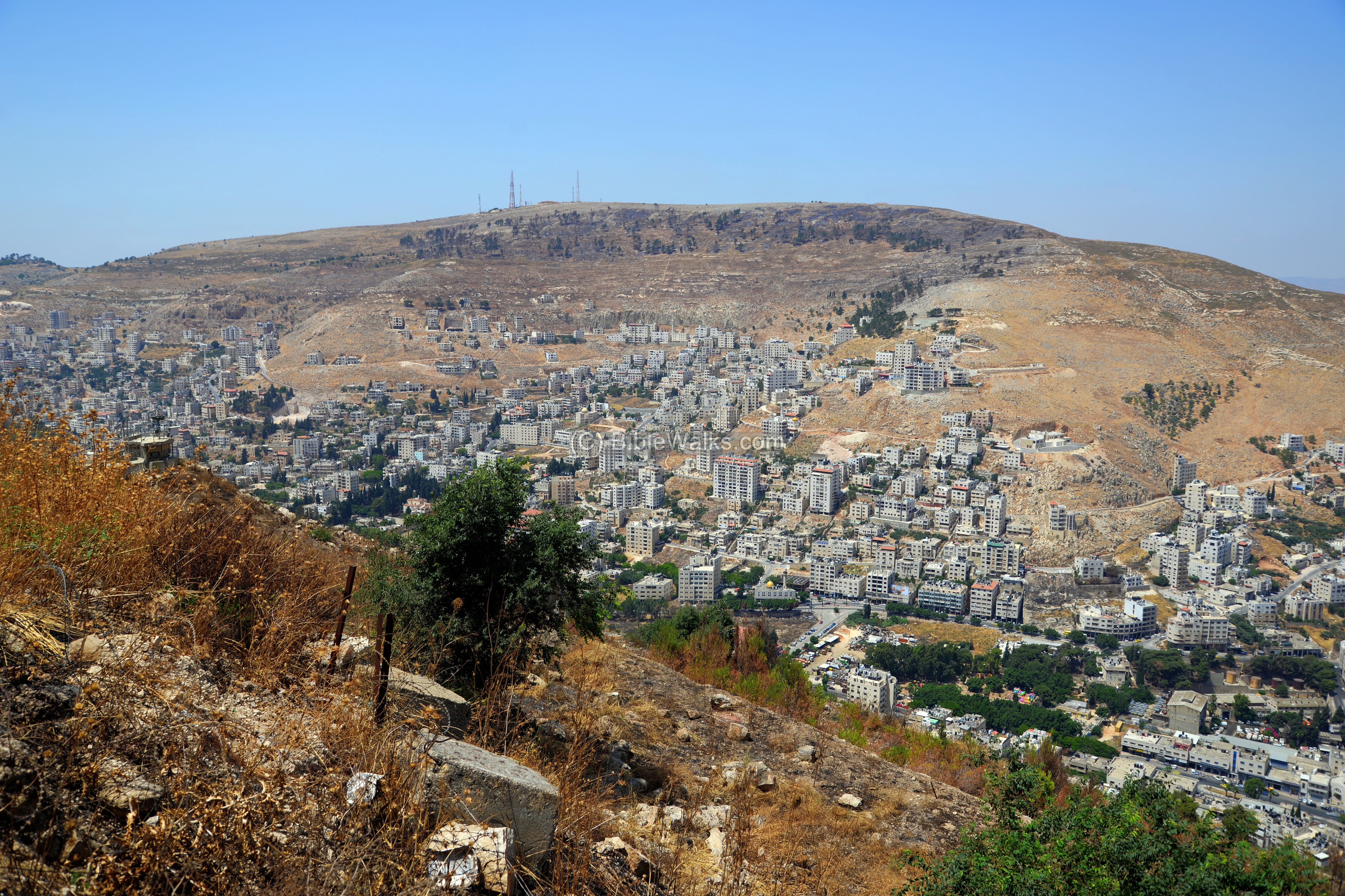
From the lookout are great views of Mt. Ebal – the barren mountain, cursed by the Bible, on the north side of Shechem. This north east view shows the modern buildings built on Mt. Ebal’s foothills.
To the east of Mt. Ebal is the valley of Michmethah. Joshua 17:7: “And the coast of Manasseh was from Asher to Michmethah, that lieth before Shechem”. The buildings of Askar, once the Roman village of Ein Sukkar, populate this fertile valley.
The stream in the valley of Michmethah flows to Nahal Tirzah. Nahal Tirzah curves around Mt. Kabir, seen in the far center, on its path towards the Jordan river. On the right background is the Jewish community of Elon Moreh.

Looking westwards, the city of Nablus (modern Shechem) is spread along the valley. The old Roman and Crusaders cities are located in that area, 2km west of Tel Shechem. In the background is the southern side of Mt. Ebal.
Biblical References:
On Shechem:
Genesis 12 6-17: “And Abram passed through the land unto the place of Sichem, unto the plain of Moreh. And the Canaanite was then in the land….”.
On the curse of Mt. Ebal and the blessing of Mt. Gerizim:
Deuteronomy 11:29: “And it shall come to pass, when the LORD thy God hath brought thee in unto the land whither thou goest to possess it, that thou shalt put the blessing upon mount Gerizim, and the curse upon mount Ebal”.
On the location of the tomb of Joseph:
Genesis 33:18-19: “And Jacob came to Shalem, a city of Shechem, which is in the land of Canaan, when he came from Padanaram; and pitched his tent before the city. And he bought a parcel of a field, where he had spread his tent, at the hand of the children of Hamor, Shechem’s father, for an hundred pieces of money”.
Joshua 24:32: “And the bones of Joseph, which the children of Israel brought up out of Egypt, buried they in Shechem, in a parcel of ground which Jacob bought of the sons of Hamor the father of Shechem for an hundred pieces of silver: and it became the inheritance of the children of Joseph.”
Etymology – behind the name:
* Names of the site (Shechem):
- Shechem – Biblical name (e.g., Genesis 12 6-17: “And Abram passed through the land unto the place of Sichem, unto the plain of Moreh. And the Canaanite was then in the land….”)
- Neopolis – Roman name, meaning: New city. Named by the Roman emperor Vespasian in 72 AD as Flavia Neapolis.
- Nablus – based on the Roman name Neopolis (‘p’ are normally pronounced as ‘b’).
* Other sites:
- er-Ras – Arabic: hill-top.
- Askar – Arabic: Army.
- Balata (Balatah) – Arabic: flagstones [from PEF dictionary, p.179].
- Kh. Lozeh – The ruin of the almond-tree.
Links:
* External links:
-
From mountain to icon: Mount Gerizim on Roman provincial coins from Neapolis, Samaria
- The excavation of Tell er-Ras on Mt. Gerizim (R. J. Bull, Univ. Chicago, 1968, 15 pages)
* Internal Links:
- Mt. Gerizim
- Mt. Ebal and Joshua’s altar
- Kiryat Luza – Samaritan village on Mt. Gerizim
- Rachel’s tomb – Near Bethlehem
- Drone Aerial views – collection of Biblical sites from the air
BibleWalks.com – walks along the Bible land
Mt. Ebal <<<—previous site—<<<All Sites>>>— next Samaria site—>>> Itamar
This page was last updated on Apr 6, 2023 (overview and history update)
Sponsored Links: