This web page explores the search for “Aenon near Salim” where John the Baptist was baptizing people.
(John 3, 23): “Now John also was baptizing at Aenon near Salim, because there was plenty of water, and people were coming and being baptized”.
Home > Sites > Jordan Valley> Aenon
Contents:
Overview
History
Photos
* Tel Shalem
* Ed Deir
* ‘Ain Buleibil
* Tell ed Deir
* Summary
Etymology
Links
Background:
John the Baptist was baptizing people at Aenon (John 3, 23): “Now John also was baptizing at Aenon near Salim, because there was plenty of water, and people were coming and being baptized”. This web page reviews the search for the baptismal place of John the Baptist. A number of candidates were reviewed during our survey of the sites around Tel Shalem.
History:
- Early Roman period – “Aenon near Salim”
John the Baptist was a Jewish preacher in the early Roman period (1st century AD). He emphasized baptism of repentance for the forgiveness of sin (Luke 3:3):
“And he came into all the country about Jordan, preaching the baptism of repentance for the remission of sins”.
The New Testament place of baptizing is called “Aenon near Salim”. This is where John the Baptist was baptizing people after baptizing Jesus in Bethany-beyond-the-Jordan (John 3, 23):
“Now John also was baptizing at Aenon near Salim, because there was plenty of water, and people were coming and being baptized”.
John Baptizing people at Aenon – AI generated by Stable Diffusion
Aenon is the Hellenized form of the term for ‘spring’, similar to Hebrew (עין) and Arabic (‘Ain). The identification of “Aenon near Salim” remains uncertain. The location of Aenon is suggested by the description that “there was plenty of water there” (John 3:23) and its position on the west side of the Jordan River. The name “Salim” may have preserved the Hebrew word “Shalem.”.
The cities and roads during the ancient periods, up to the Roman period, are indicated on the Biblical Map below. One of the sites, a spring and pool near Tel Shalem, may have been John’s baptismal site, or around it.
Tel Shalem is on the path of a major south/north ancient road along the Jordan valley, depicted here as a grey dashed line (Dorsey’s Bronze/Iron age route ‘A3’). It is not far from the Jordan river, as illustrated as a blue line, where a river crossing crossed the ford to the eastern side of the river.
Map of the area of Beit Shean valley – during the Canaanite and Israelite periods (based on Bible Mapper 3.0)
- Tel Shalem identification:
Eusebius of Caesarea, a 4th-century Greek historian of the Church, offered identifications of Biblical places in the Holy Land in his book Onomasticon. In this book he proposed that “Aenon near Salim” was located at “a village in the (Jordan) valley, at the eighth milestone from Scythopolis, … called Salumias.”. The reference to Salumias in Eusebius’ work indicates that this village was known during the late Roman period and was part of the wider network of Roman settlements in the region. The 8th milestone fits the distance from Beit-Shean/Scythopolis to Tel Shalem (8 Roman miles is 12km).
Although direct archaeological evidence specifically identifying Salumias at Tel Shalem is limited, the discovery of Roman-era artifacts, such as the statue of Hadrian and remnants of Roman fortifications, suggests that the area was indeed inhabited and significant during the Roman period. In recent study (2025) of the spring north of the mound, an extraordinary amount of Roman/Byzantine pottery and structures were found buried around the spring. This evidence provides a reasonable basis for associating Tel Shalem with the location of John’s baptizing place. The site was forgotten over the years, as the area around the spring may have been damaged as a result of the flooding of the area with mud in 634 AD.
W.F. Albright visited Tel Shalem in 1925 and suggested another identification at a southern site at ‘Ain ed-Deir, siding with Abel However, Albright based his view on the wrong assumption that there are no Roman ceramics on Tel Shalem.
- ‘Ain ed-Deir
There are other candidates suggested for the place of Aenon. There are many springs in the vicinity of Tel Shalem. Some of them are springs south of Tel Shalem.
One of the springs is named ‘Ain ed-Deir (“the spring of the monastery”). Its waters, flowing out of a square pool, are conveyed to an aqueduct. Ruins of a Byzantine Monastery, located near the spring, are built on a small mound (Tell ed-Deir, also Umm el Amdan) above the swamps. The monastery is now in ruins and scattered in the farming fields. François-Marie Abel visited the site in 1910 and identified Aenon at this place. The presence of a monastery gives a higher confidence to this identification.
There are other springs around ‘Ain ed-Deir, with remains of the Roman/Byzantine period. This web page reviews these sites.
- Near Jericho
Another candidate is illustrated on the Madaba map, an ancient map of the Holy Land from the 6th century AD. It is illustrated on the mosaic floor of a Byzantine church in Madaba, Jordan. The map shows Aenon near Jericho in the south of the Jordan river, on the other side of Bethany-beyond-the-Jordan. The orientation of the mosaic map is north on the left side, with the Jordan river flowing into the Dead Sea on the right. The text near each of the places reads “Aenon, where now is Sapsaphas” (modern Wadi el Kharrar, east of the river) and “Bethabara, the place of baptism of St. John”.
However, that map showed the 2 baptizing places are flipped in position: Aenon is shown on the east side of the Jordan river rather than west side, while on the facing west side is Bethany (Bethabara – another form of the name). This was probably because Madaba is on the other side of the Jordan river, and “beyond-the Jordan” implies it is on the east side.
P/o Madaba Map – a section near Jericho
Placing the baptizing sites near Jericho contradicts the timeline in the Gospel of John (John 2:1), where the travel from the site to Cana of the Galilee took one or two days. According to the timeline, the place of baptizing was close to the Lower Galilee and farther north of Jericho.
- Ottoman period
The site around Shalem was examined in the PEF survey (1866-1877) by Wilson, Conder and Kitchener. A section of their map is seen here. The map is part of sheet 12 of their survey results. They wrote about Tel Shalem – in Arabic it was called Tell er Ridhgah (Volume 2, p. 247):
“Tell er Ridhghah —A low mound, apparently artificial. On the north a good spring and a few ruined houses, with the little ruined dome of Sheikh Salim”.
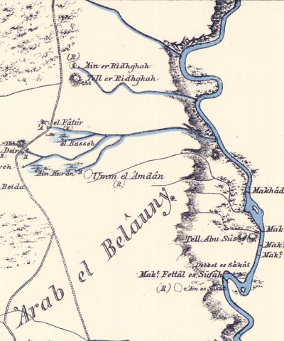
Part of Map sheet 12 of Survey of Western Palestine,
by Conder and Kitchener, 1872-1877.
(Published 1880, reprinted by LifeintheHolyLand.com)
Notice in the map that near the site are several river crossings on the east side, with a “Makt” prefix. These crossings were on foot at convenient points where the flow of the Jordan river slowed down and allowed walking on the river bed. The map also shows a double-dashed road that passed west of the mound and bypassed the springs, marked as a Roman road in another section of the map. Its route follows the same north-south route as the modern road #90.
The PEF surveyors wrote about Salim (Volume 2, map XII, p. 230):
“In the fourth century Salim was shown 8 miles south of Beisan (‘Onomasticon ‘), and supposed to be the town of Melchizedek. A Salim is also marked in this position on the map of Marino Sanuto. The measurement brings us to the place called ed Deir, the remains probably of a monastery, in the neighborhood of which there are seven springs and extensive ruins.
About a mile to the north is Tell er Ridhghah, with another spring, and in the ruins a kubbeh, to which Vandevelde obtained the name Sheikh Salim. The inquiries of the Survey party in 1874 and again in 1877 did not prove successful in recovering this name (see Report by C. F. Tyrwhitt Drake, ‘Quarterly Statement,’ January, 1875, p. 32), but there can be little doubt that it was once known, as it was apparently also recovered by Robinson in 1856, and there seems every probability that this was the accepted site in the fourth century, though the absence of the name Aenon and of any marks of great antiquity seem to make it doubtful whether it is to be held the true site”.
- British Mandate
Tel Shalem was named in the British period maps as “Tell er Radgha”. A sheikh’s tomb (Esh Sheikh Radgha) appears on the north west. A spring (marked as SP) appears on the north side. A Sheikh’s tomb, named here Esh Sheikh Radgha, but was also known as Sheikh Salim, is located west of the spring. Several aqueducts (“qanat”) convey the spring’s waters to the fields around it.
An old photo (c. 1948) shows the spring prior to the construction of the fish pond. Tel Shalem is seen in the background to the south of the spring.
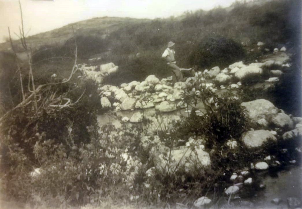
Photo courtesy Sturman museum, A. Keidar
A farming Arab village, el Fatur, existed south of the site at that time. A Sheikh’s tomb, Esh Sh. Fatur, is located at the side of a spring (‘Ein Abu ‘Atif). Its waters flow to the valley of Khor Buleibil, continuing east to the Jordan river (2km away), joining several other springs: ‘Ein Buleibil (there are 2 springs on the map with same name), ‘Ein ed Deir, ‘Ein Abu Natif and ‘Ein el Qur’an.
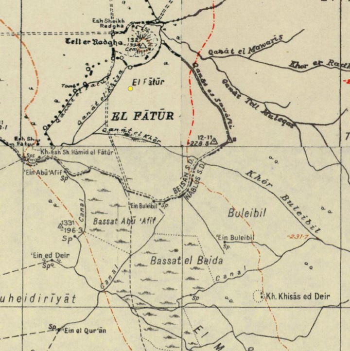
British survey map 1942-1948 – https://palopenmaps.org topo maps
License: public domain under the UK Copyright, Designs and Patent Act 1998
- Modern Period
The area of Tel Shalem and the springs of Ed Deir were surveyed by the team headed by Adam Zertal and published in Volume 4 of “The Manasseh hill country survey”. The area of Tel Shalem received high archaeological interest after the discovery of Hadrian statue, fragments of the victory arch, and the Roman military camp.
However, due to the damages created by farming, wars and military activities over the years, the information we know about the area is limited. Looking for Aenon near Salim in this area is a challenge. In the remainder of this page we attempt to solve the identity of John’s baptismal place, and suggest several candidates.
Photos:
This section is divided to 4 locations in the area of Tel Shalem that might have been “Aenon near Salim”.
(a) Tel Shalem
Tel Shalem is a low elliptical mound, built on the south bank of the stream flowing from Ein Avraham spring. It was damaged by military works as part of the defenses along the Jordan river. Read more on Tel Shalem on a separate page.
The aerial map below shows the area around Tel Shalem, indicating the main points of interest. Tel Shalem is 2km south of Kibbutz Tirat Zvi. Access is via road #6678 to Kibbutz Tirat Zvi, and then along the fish ponds. The Kibbutz is closed on Shabbats, so an alternative way is from Horvat Menorah then along a dirt road bypassing the Kibbutz.
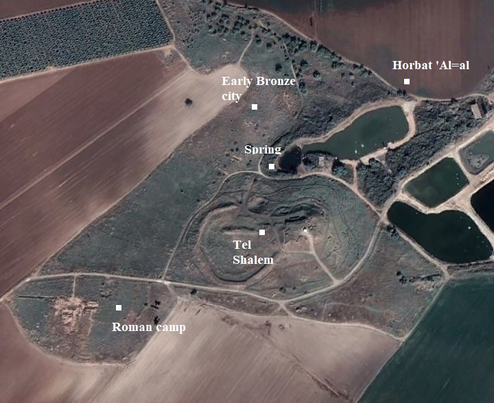
On north side of Tel Shalem is Ein Avraham spring- a modern name of the spring commemorating a fallen soldier. Its Arabic name is ‘Ain er Ridhghah (name after the mound). The waters of the spring flow eastwards and fill up the pool.
This view from the top of the mound towards the spring and its adjacent pool. A concrete structure, housing a pumping station, is seen here on the left side.
The spring and its pool are likely to be known as the New Testament place called “Aenon near Salim”. This is where John the Baptist was baptizing people after baptizing Jesus in Bethany-beyond-the-Jordan (John 3, 23): “Now John also was baptizing at Aenon near Salim, because there was plenty of water, and people were coming and being baptized”.
The identification of “Aenon near Salim” remains uncertain. However, let’s check whether the Biblical description fits this place:
a) The location of Aenon is described as “there was plenty of water there” (John 3:22); this spring is the most bountiful and sweetest spring in the area.
b) Its position was on the west side of the Jordan River (i.e., not beyond the Jordan as in the first baptismal of Jesus described in chapter 1:28).
c) The name “Salim” may have preserved the Hebrew word “Shalem.”.
d) A shrine or tomb of “Sheikh Salim” on the north west side of the mound preserved the name.
e) Adding to these, Eusebius of Caesarea, a 4th-century Greek historian of the Church, identified this place as Aenon.
…All of these features check out with this place!
Below – a view from the the other side of the pool, with Tel Shalem towering over the area.
- Search for the Lost Church of St. John:
So we are on a special place that may be associated with the Saint John the Forerunner! Therefore, there must have been a monastery during the Byzantine period that honored John.
We looked around the spring. Previous surveys (A. Cohen 2010, site 102) described a structure built of large stones that was covered by the pool near the spring. This may have been part of the Byzantine church, perhaps with a ritual immersion pool.
In the photo below – a view of the spring from the east side. The spring is hidden behind the palm tree.
The area around the spring is fenced and mined, and so it is difficult to search for the antiquities. Behind the fence were many fragments of tiles, ceramics and mosaic floor stones.
Roof Tiles:
On the ground above the access road, and also behind the fence of the mines, we noticed a large group of Roman/Byzantine tiles on the other side of the road. Here is the collection of roof tiles that we saw, with many more buried around. This was a first indication that a ruined Byzantine Church is lying around here.
Some of the roof tiles had engraved circles. This pattern on roof tiles is unique.
Mosaic floor:
Another sign that a ruined church is located here was finding sections and stones of mosaic floors with cement holding the pieces together.
Another section of the floor, with black and white stones, was observed inside the mined area.
Early Roman bowl:
A Muslim colored sherd:
Roman/Byzantine jug:
Roman handles:
Below – A Crusader/Mameluke ceramic piece; may have been used in the Sugar cane industry. The cultivation of sugarcane required abundant water for irrigation. Furthermore, large scale production required water for powering the mills to crush the canes. This industry flourished in this area (also known as the “valley of springs”).
A long metal nail:
These findings encourage us to continue look for more signs of a Byzantine structure that may have been associated with “Aenon near Salim”.
![]() Fly around the site near Tel Shalem with this YouTube video.
Fly around the site near Tel Shalem with this YouTube video.
Video captured on Aug 2024
An overview of our survey of the site on the north side of Tel Shalem:
Video captured on Feb 2025
Draining the Lake
In April 2025 the lake on the east side of the spring was drained, in order to clean it as part of the fish pond maintenance. The surface of the dried out north bank was now visible, as seen below. A small stream was still flowing from the pool of the spring, seen here on the right side, which at that time was still covered by a black mesh net, and full of water.

Along the surface of the north bank were visible sections of structures, such as this one where a threshold stone is seen and a section of a wall. Using a drone and creating a 3D view of the drained surface, we were able to see sections of walls on both the south and north banks of the stream that starts from the pool of the spring and flows ~100m eastwards.
The surface was littered by thousands of ceramic fragments, pottery handles and roof tiles, dated to the Roman/Byzantine period. We were surprised by the amount of pottery that was seen along the dried surface, indicating that this place was visited by many people over a long period during the Roman/Byzantine period. Here is a sample of the ceramics, which include a roof tile and vessel handles.
This finding provides a stronger evidence on the likelihood of this site to be the baptismal site, and the possible location of the lost Church of John the Baptist. A future excavation on the site could further strengthen this identification.
The following video shows an overview of our survey of the drained lake on the side of the spring:
Video captured on Apr 2025
(b) ‘Ain Ed Deir (Ein Arnon)
Other candidates for the place of Aenon are found 1km south of Tel Shalem, where at least 7 springs are found within a small area of 1km by 2km. This area and the other parts of the valley north of here are nicknamed “The Land of springs”. Note that these springs are in area ‘A’ and caution should be taken.
One of the springs is named ‘Ain ed-Deir (“the spring of the monastery”).
The PEF survey wrote about Ed Deir (Volume 2, Map XII, p. 236):
“Ed Deir —The northern site by the seven springs in the Jordan valley. This name is applied to a ruined wall by the spring…”.
However, they added a note that this wall is not promising: “…The real site seems to be at Umm el ‘Amdan” (another place nearby). Indeed, the wall by the spring seems like part of a dam.
We expected to find a monastery – a sign indicating a possible association to John’s baptismal, but that’s not what we found. So we looked in the fields north of the spring. The aerial map below shows the area around ‘Ain Ed Deir, indicating the main points of interest.
Ancient ruins are located north of the spring, on and around a small (60x90m) mound (Tel ‘Ain Ed-Deir). The mound was damaged by the farming, and is scattered in the fields around it. Also, large Iron poles were dumped on the mound.
A. Zertal (Vol 4, site 23, p. 154-156) estimated the total area at 10 dunams. The survey team dated the ceramics to MB2 (15%), LB (10%), Iron 1 (30%), Iron 2 (40%), Hellenistic (5%).
Indeed, that’s what we also found – a majority of Iron Age (as seen below). No Roman/Byzantine fragments were found, so the site was not related to John’s baptizing site.
Another piece we found was a mud brick, used as a building block during the Bronze/Iron Age periods.
One of the interesting pottery finds was an Iron Age chalice (footed cup, goblet, Hebrew: קובעת) that was used in burial practices.
Another finding was a large grinding base.
A. Zertal concluded that the site was a medium sized Iron Age village, with pottery similar to nearby Tel Hammath and Tel Malkoach (Mekehaz). Indeed, this site seems like a village on the route from Samaria to the river crossing of Abu Sus and Sakut. In the following photo, with a west view, Tel Hammath is seen on the left background in front of the Samarian foothills.
(c) ‘Ain Buleibil (Ein Yavok)
This spring is 1km south of Tel Shalem, 800m north east of ‘Ain ed Deir. It is the closest spring near Tel Shalem, and its waters flow north east to the valley known as Khor Buleibil that separates both sites.
The aerial map below shows the area around ‘Ain Buleibil, indicating the main points of interest.
Khor Buleibil is marked on the north side of the spring. The word Khor means ‘stream’ in Arabic. During the British period this stream was considered part of the international boundary between Palestine and Trans-Jordan. Today a security fence along the valley separates between Israel and the West Bank area.
On the edge of the pool is a deck, tables and swing chair. Many flock to the springs in this area during the spring and summer time.
Ceramic dating by A. Zertal (Vol 4, site 24, p. 157) dated pottery fragments and flint stones to the Chalcolithic period. The survey suggested that a large 30 dunam Chalcolithic settlement was buried under the fields between this spring and another spring with the same name 400m north west (as seen on the British map). The satellite view indeed shows a brighter area in this area.
Possible ruins of a Roman built structure were found buried under a higher ground area south east of the spring. In this smaller area Zertal dated the pottery to the Late Roman period. The area of this higher ground place is 20x25m, as reported by Zertal (p.156), and a ruin of a structure was buried under the ground.
The place is seen below, with the adjacent spring (‘Ain Buleibil ) seen on the right side of the photo. Are these findings belong to a Byzantine monastery dedicated to John the Baptist?
In our brief visit we noticed several interesting architectural stone elements, probably dated to the Roman/Byzantine period. They could indicate that a Roman/Byzantine structure (monastery?) was built here at the side of the spring, commemorating the baptismal place of John.
Note that the bars on the stick are 10cm in length.
Another architectural element:
Parts of floorings were also observed:
(d) Tell ed-Deir
Another site nearby is a flat and low mound, located 1km south of ‘Ain Buleibil. The site, rising 20m above the area, covers an area of 10 dunams.
The aerial map below shows the area around Tell Ed Deir, indicating the main points of interest.
On its north east side was a spring, now dried out. Sections of structures were once seen on the mound.
Gofna and Porat (1972, site 50) described the site as covering 2 dunam, with a majority of Byzantine ceramics. The name ed-Deir implies that there was a monastery here.
In the PEF map a site Umm el-Amdan (“Mother of Pillars”) is shown here, also implying that a grand structure (monastery?) was standing here. The PEF survey wrote about the place (Volume 2, Map XII, p. 247):
“Umm el ‘Amdan —Scattered stones and traces of a considerable ruin ; several fallen pillar shafts. The place was all covered with mallows and other flowers when visited”.
Here is a view of the bottom of the hill, looking towards the south. This was probably the location of the spring.
Hewn stones were seen on the bottom of the north side.
Ceramic dating by A. Zertal (Vol 4, site 28, p. 157) dated the fragments to the Chalcolithic period, thru the Byzantine period (minority), continuing to the Middle Ages (majority). We collected some sherds and dated them. All items were left on the site.
Mameluke sherds:
Roman/Byzantine sherds:
Iron Age sherd:
And another item we noticed, not ancient: a horn:
Based on the pottery sherds, the name of the mound and the spring – this site may also have been a monastery, perhaps dedicated to John the Baptist. However, there are no “plenty of waters” here and therefore this site does not seem to fit the description of Aenon.
(e) Summary
We have identified several locations with springs and Byzantine ruins around Tel Shalem. This suggests that monks may have established places of worship and residences in this area during the Byzantine period, possibly associating it with the site of Aenon, where baptisms were conducted.
We believe at this point that the spring on the north side of Tel Shalem is the best fit. However, we will continue to search for more clues to uncover the exact location of Aenon.
Etymology – behind the name:
- Aenon – Hellenized form of the term for ‘spring’, similar to Hebrew (עין) and Arabic (‘Ain).’
- Tell er Radgha, Tell er Ridhghah, Tell Ridgha – Arabic: “The mound of the mud”. This name was given due to the event of the battle between the Byzantines and the Muslim Arab forces in 634 CE, when the reservoirs were opened to flood the valley with mud as a desperate defensive tactic by the Byzantines to slow down or stop the advancing Arab forces. Flooding the area would have created a difficult, muddy terrain, potentially hampering the movement of troops and horses.
- Tel Shalem – the Hebrew name.
- Sheikh es Selim – a ruined Sheikh’s tomb on the north west side of the mound, an Arab name that preserved the ancient name.
- Salumias – the Roman village located at Tel Shalem (according to Eusbesius)
- El Fatur – Arabic: meaning the fissures, rocks and a spring.
- Umm cl ‘Amdan. Arabic: “Mother of Pillars”.
- Buleibil, Bulaybil – Arabic: a small, or cute, Nightingale bird (Bulbul)
- Khor Buleibil – Khor: a stream; was used as a border.
Links:
* External links:
- “The Manasseh hill country survey” Volume 4 [Adam Zertal , 2005]
- Site 18 – Tel Shalem (pp 144-147)
- Site 23 – ‘Ain ed-Deir (pp. 154-156)
- Site 24 – ‘Ain Buleibil (pp. 156-157)
- Historical cartographic materials as a source for international and cadastral boundary management in rivers – Khor Buleibil – a border line
- Wadi al Kharrar – possible site of Bethany Beyond Jordan
- Aenon near to Sâlim – Benjamin W. Bacon; The Biblical World, Vol. 33, No. 4 (Apr., 1909), pp. 223-238 (16 pages)
- The Land of springs – area of ed-Deir (Hebrew, Nelech), with map
- The discovery of Aenon (saleem) near site of Jesus baptism – Mohammad Waheeb, RG 2018
* Internal links:
- Aqueducts – information page
- Roman roads – info page
- Mosaic floors – info page
- Sugar history
- Byzantine monks
- Tel Shalem
- Miqveh installations – ancient baptizing
- YouTube – BibleWalks’ aerial views
- Flight over Ein Avraham – YouTube video.
- Video of our survey of Aenon at Tel Shalem
BibleWalks.com – search for Biblical places
Tel Shalem<<<—previous site—<<<All Sites>>>—next Jordan Valley site—>>>Horvat Kush
This page was last updated on Apr 11, 2025 (text update, add illustration)
Sponsored Links: