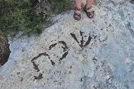
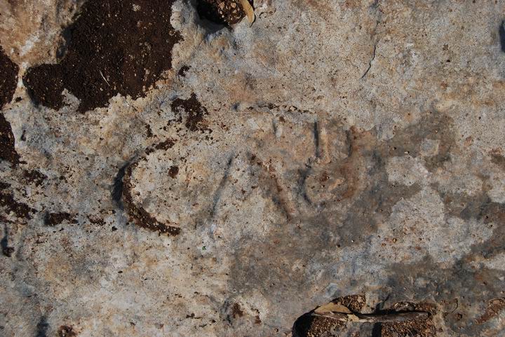
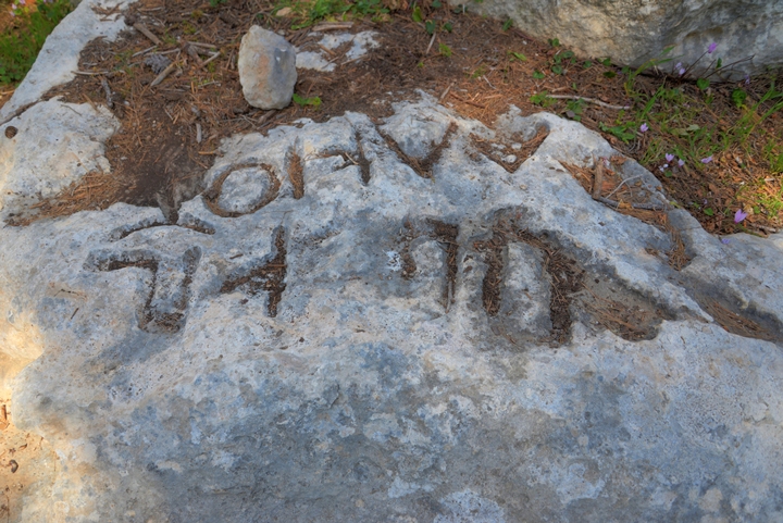
Sabbath boundary marker found in Timrat, with 3 letters in Hebrew. The marker was dated to the Roman period.
* Site of the Month Nov 2018 *
Home > Sites > Yizreel Valley > Sabbath Stone in Timrat
Contents:
Overview
Background
History
Photos
* The stone
* Search for more
* Mixed Borders
* Other Sabbath stones?
Biblical
Archaeological
Etymology
Nearby sites
Overview:
A boundary marker was found near the Galilee community of Timrat. It had 3 faint letters that were inscribed in Hebrew, spelling: “Sabbath”. This exciting and unique finding, first identified by BibleWalks, was confirmed to be dated to the Roman/Byzantine period.
Background – work not allowed on Sabbath:
According to Jewish customs, work is not allowed during Sabbath or Holidays, including traveling outside of the place of residence. According to the Biblical commands (Exodus 16:29):
“See, for that the LORD hath given you the Sabbath, therefore he giveth you on the sixth day the bread of two days; abide ye every man in his place, let no man go out of his place on the seventh day”.
This prohibition was translated by the second temple period Rabbis to a certain limit where it was allowed walking during the Sabbath or Holidays within the boundary of a village. The Sabbath boundary was defined as a distance of 2000 cubits (about 1km), as measured from the edge of a settlement to all directions. This measure is also termed as a “Biblical mile”.
The area of the village covered the cluster of houses within a settlement, and included all houses within the range of 70 cubits from one each other.
The illustration shows the allowed walking zone around the village.
In 2011 BibleWalks identified a Roman period marking, with the Hebrew letters “Sha-ba-t” inscribed on a natural rock in Timrat. It is located near the ruins of Roman/Byzantine period Jewish villages, within the range permitted for walking on a Sabbath. This was the first ancient Sabbath marking found in Hebrew in the Galilee.
History of the place:
-
Roman/Byzantine periods
In the vicinity of Timrat are ruins of three Roman/Byzantine Jewish villages, that were probably related to the Sabbath stone:
The Jewish Roman town was called “Mahalul”, and flourished from the commercially strategic location during the Roman/Byzantine times. It is mentioned in the Jerusalem Talmud (Megila page 2 , 2 1:1, Hebrew): “Nahalal is Mahalul”, and listed among the walled cities from the period of Joshua.
The town was probably destroyed in the Arabic period (8th century AD), and the site was in ruins for many centuries.
During the Second temple period, a Jewish town called Simonia was established on the western footsteps and around Tel Shimron. It flourished from the commercially strategic location until the Roman times. The town was spread over the hills around the Biblical Tel. The foundations of Simonia can be seen all over the area, including caves, cisterns, wine and oil presses, and quarrying sites.
- Horvat Qisi (Qattat/Qattonit?)
This ruin is located 1.5km north of the marker. It was suggested by Z. Erlich and Y. Shivtiel as a possible option for the Sabbath marker. They also based on the fact that the marking is oriented to the north, and so that it was intended to mark the boundary for the walkers from the north.
In the ruins, which were not previously marked on the maps, are traces of a settlement, agriculture installations, cisterns, and hiding complexes. According to their survey and the existence of hiding complexes, they dated the settlement and concluded it was one of the Galilean Jewish villages.
They suggested the village Biblical name was Qattat (Joshua 15:10,19): “And the third lot came up for the children of Zebulun according to their families:… And Kattath, and Nahallal, and Shimron, and Idalah, and Bethlehem: twelve cities with their villages”. During the Roman period the village was renamed Qattonit, based on the Jerusalem Talmud (Megila page 2 , 2 1:1, Hebrew): “…and Qattat is Qattonit”.
-
Sabbath boundary in the scriptures
The Sabbath boundaries in the Galilee villages are documented in the Babylonian Talmud, a 2nd century AD collection of Jewish practices. A section from Babylonian Talmud (Sanhendrin 14) tells the story of Rabbi Judah Ben Baba which relates to the Usha site, the first seat of the Sanhedrin in the Galilee. This Rabbi defied the orders of the Romans to avoid ordinating (=giving a degree of a Rabbi) to others. These orders followed the second revolt against the Romans (131-135 AD: Bar-Kochva), and his act resulted in his death by the Romans, but helped to continue the Jewish leadership during these tragic days.
“… because once the wicked Government, decreed that whoever performed an ordination should be put to death, and whoever received ordination should he put to death, the city in which the ordination took place demolished, and the boundaries wherein it had been performed, uprooted. What did R. Judah b. Baba do? He went and sat between two great mountains, between two large cities; between the Sabbath boundaries of the cities of Usha and Shefaram and there ordained five elders: R. Meir, R. Judah, R. Simeon, R. Jose and R. Eliezer b. Shamua’. R. Awia adds also R. Nehemia in the list. As soon as their enemies discovered them he urged them: ‘My children, flee.’ They said to him, ‘What will become of thee, Rabbi?’ ‘I lie before them like a stone which none overturn, he replied. It was said that the enemy did not stir from the spot until they had driven three hundred iron spear-heads into his body, making it like a sieve”.
-
Modern period – discovery of the Sabbath Stone
In 2011 Nathan Ben Jehuda walked with his dog near his grandson’s house in Timrat, a community located north east of Tel Shimron. Nathan observed some very faint markings on a rock at the edge of Moran street. He notified this curious finding to a neighbor, Uncle Ofer, who came and photographed the stone. That evening, Ofer called his brother, Yoram, and told him that there are probably three letters on the stone but not sure what they mean. Perhaps Hebrew letters reading: S-cha-Kh (forget?).
Yoram, the father of Webmaster Rotem and a major contributor to BibleWalks, knew and documented a similar rock marking near Horvat Usha. That marking contained Greek letters, including the letters “CAB”, which some scholars suggested it meant CABAT (Sabbath), relating it to the Talmudic reference of the Sabbath boundary of Usha. However, there were other suggestions on the meaning of the letters, and so it remained a puzzle for years.
Excited, Yoram translated the Timrat marking to the letters “Sha-ba-t”, meaning: “Sabbath”. On the next day he visited the site of the discovery and realized that this was an important discovery, and posted it on BibleWalks blog.
To confirm this finding, Uncle Ronni (the third brother) contacted Dr. Motti Aviram, an archaeologist who they were acquainted previously with other archaeological activities. Motti, a senior member of the Kinneret Institute for Galilean Archaeology, came to the site and confirmed the antiquity of the marking. He dated it to the Roman/Byzantine period, 3rd to 6th century AD.
The public announcement of the finding quickly spread in the Worldwide media.
Photos:
(a) The stone:
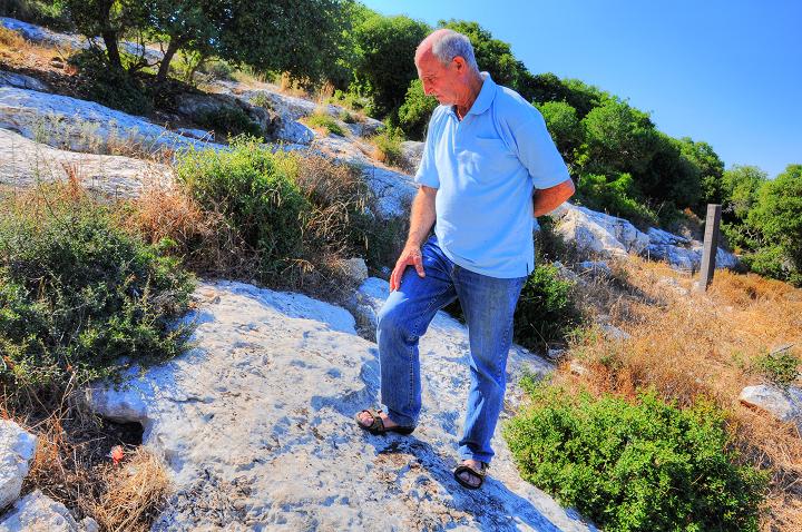
Nathan walked here with his dog on a trail at the edge of Moran street. He observed faint letters on the rock just above the trail. He is seen here a foot below the place of the Sabbath marker.
Click on the photos to view in higher resolution…
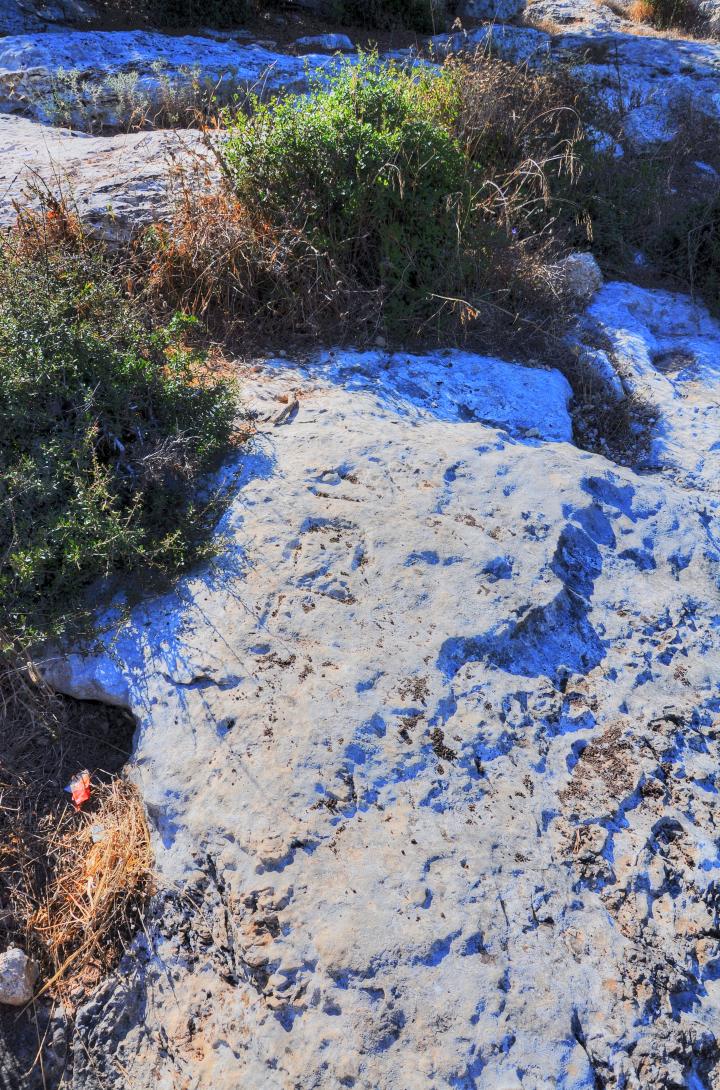
The engravings are hard to see, and only at a certain time of day the markings could have enough contrast to make the letters stand out of the white surface of the rock. The archaeologist, who observed the patina (thin layer) of the letters, determined that their color is identical to the rock’s surface, which indicates that the marking is old.
Placing some dirt on the grooves, the 3 Hebrew letters שבת (Sha-ba-t) are visible. The inscription is 62 cm long, and the height of the letters is 20cm.
The first and third letters are very clear, while the middle letter has a short tail on the right. The letters are written in the similar typeface as other Roman period Jewish inscriptions.
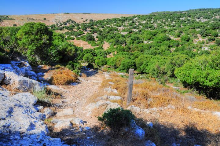
A path leading to the north is adjacent to the Sabbath marker. This trail is modern, but could have been the same route during the Roman period, and why the marker was inscribed near it.
(b) Search for more Stones:
If one stone was found – couldn’t there be more in this area? According to Jewish practices, the Sabbath boundary is to all directions. In modern times, a wire is hung on poles around religious communities to mark their greater area. Therefore, it is plausible that more stones could be out there.
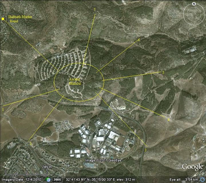
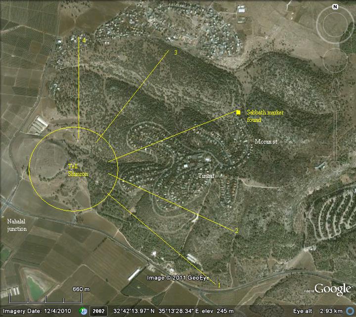
BibleWalks prepared two maps where to search these stones, and called the public to try to locate them. Assuming that the marker is on such boundary, and at a distance of about 1km from the edge of an ancient village, then these locations may be candidates for more stones.
The first map is around the ruins of Roman period Mahalul, with areas 1-7 marked on the map.
Another option is that the marker was on the boundary of the Roman period village of Simonia, around Tel Shimron.
(c) Between villages (“Mixed borders”):
A special exempt from the Sabbath city limit of 2000 cubits allows an extension of another 2000 cubits beyond the city limit. It is named Eruv Techumim – Hebrew for “mixed borders”. This exemption applies in cases two villages are within 4000 cubits, allowing walking between them after the Sabbath starts in Friday evening. This exemption is allowed by two options – (a) physically standing at the Sabbath boundary just before sundown when the Sabbath starts, then walking the extra distance, or (b) by placing food before sundown on a spot at the Sabbath boundary.
The Eruv Techumim exemption allows walking another 2000 cubits from that point to the neighboring village. Is this the case of the Sabbath marking in Timrat? According to this theory, the marker was in the middle between two villages to the north of the marker. Perhaps in this case – between Mahalul and/or Simonia on the south, and Horvat Qisi (Qattat, Qattonit?) on the north.
The following map shows the area north of the Sabbath marker stone. Horvat Qisi may have been the reason why the Sabbath marker was inscribed there – as a “mixed borders” marker.
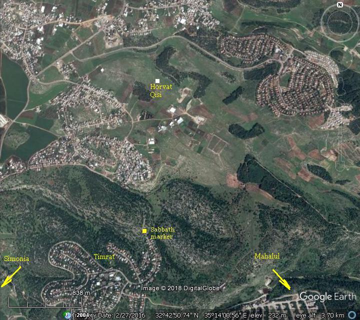
Uncle Ofer also suggests that while the “Eruv Techumim” location is a permanent spot between two villages, the Sabbath boundary may move in time due to the expansion of the settlement. Therefore, the former custom was marked permanently on stone, while the latter was a temporary pile of wood or other types of makeshift markings. This theory makes the Sabbath marker in Timrat more likely to serve the allowance of walking between two villages rather than setting the limits within the village.
(d) Other Sabbath markers in the Holy Land?
In the Holy Land are two known cases where there could have been additional Sabbath markers.
1. Usha:
The first one is in the Western Galilee, between Usha and Shefaram – both Jewish villages and places where the Sanhedrin (Jewish religious and administrative leadership) council was stationed during the 2nd century AD.
A detail of the inscription is seen below. The letters “CAB” seen below are considered as the prefix of the word CABAT – Shabbat. However, scholars argue on the meaning on these letters.
2. Gezer
Another known case are the boundary inscriptions of Gezer, where 13 markers were found (so far) around the site. They all (but 2) read AΛKIOY (Alkios) in Greek letters, and “תחם גזר” in Hebrew: “the Boundary of Gezer.” Some scholars suggested that the boundary refers to the Sabbath perimeter, while others relate them to mark the city limits, which is more likely. The dating of these markers is probably during the Hellenistic/Hasmonean period.
![]() Read more on the Gezer Boundary inscriptions.
Read more on the Gezer Boundary inscriptions.
We call the public to look for more such markers. Either by locating the possible boundaries of 2000 cubits around ancient Jewish Roman settlements, or between two villages for the Eruv Techumim custom.
Biblical References:
Archaeological References:
-
Important archaeological finding – Kinneret Academic college – July 11, 2011 (Hebrew)
-
Timrat – Sabbath marking (Hebrew)
-
Horvat Qisi – “Al Attar”, Vol. 19, 2016, pp 5-23 [Z. Erlich and Y. Shivtiel (Hebrew, pdf ]
Other Sabbath stones?
-
Usha Roman road and marker
Etymology (behind the name):
-
Nahalal – the source of the Biblical name is not clear, but may have based on the Canaanite name of the city that preceded the Israelites – maybe “Nahal”. In Hebrew “Nahal” may mean “managed” or “guided by” or “lkead by”. Thus the name may be interpreted as “guided by God”.
In Psalms 23: 2 (“He maketh me to lie down in green pastures: he leadeth me beside the still waters.”) the Hebrew word “Yenahaleni” is associated with herds and water, so the name may mean “led to the water”. The area is indeed rich in springs and may have been the source of the name.
-
Mahalul – the name of the Talmud/Mishna period Jewish town, preserved the Biblical name.
-
Ma’alul – the Arabic town, preserved the Jewish name.
-
Timrat – A new settlement west of Ma’Alul; named after the tree Tamar (Hebrew: palm tree). Initially it was a Kibbutz (est. 1947) called “Timorim”, which relocated to the south in 1954. In 1981 the site was re-established as a community settlement.
Other ancient sites close to the stone:
Ancient villages in the vicinity of the site:
- Tel Shimron – the Biblical site south west of the marker
- Nahalal – Mahalul – the Biblical site south east of the marker
- Horvat Qisi – 1km north of the Sabbath stone
BibleWalks.com – walk with us through the sites of the Holy Land
Nahalal <<<—previous site—<<<All Sites>>> —Next Yizreel Valley site—>>> Migdal Haemek
This page was last updated on June 6, 2018 (Added link to Qisi)
Sponsored links:
