Horvat Kush is a multi-period settlement in ruins, strategically positioned with a commanding view of the Yavne’el Valley. It is identified as Biblical Lakum.
Home > Sites > Jordan Valley> Horvat Kush (Khirbet el Kushsha, Khirbet el Mansurah)
Contents:
Overview
Aerial Map
History
Photos
* Yavne’el valley
* Fortified complex
* Casemate walls
* Upper Area
* Ceramics dating
* Basalt Tools
* Aqueduct
Etymology
Links
Background:
Horvat Kush (Khirbet el Khushsha or Khirbet el Mansurah), situated in the Yavne’el Valley, contains remains from several historical periods, ranging from the Bronze Age, Iron Age, Roman/Byzantine, and later periods. Remains of residential buildings, casemate walls, aqueducts and agricultural structures and installations have been discovered at the site. It is possibly an Iron Age II fortification that guarded the pass, identified as Biblical Lakum.
Map / Aerial View:
The aerial map below shows the area around the site, indicating the main points of interest. The site is located at altitude -137, about 40m above the stream west of Horvat Kush. To the west of the site are a number of springs that feed to the perennial stream. The Jordan river flows 1km west of the site.
History:
- Prehistoric periods
A nearby site, 800m south east of Horvat Kush, is Ubediyah – one of the oldest and famous prehistoric sites in the world. The prehistoric site of Ubeidiya is located on the banks of Nahal Yavne’el stream. Archaeological excavations identified 150 layers, Homo Erectus bones, mammal bones (120 types) and more than 10,000 ancient tools. This is the earliest site of Homo Erectus found outside Africa, starting from 1.4 Million years ago (Ma).
- Bronze and Iron (Biblical) Age
During the Iron age, a fortress was built on the hill above the valley, guarding an important route along the Yavne’el (Jabneel) valley. The site was part of a network of fortified settlements that were positioned by the Israelite northern kingdom at strategic locations along major roads. A nearby spring provided the settlement with fresh water supply, and farming fields around it provided food supplies.
The plan of the settlement was based on casemate walls that were built around a central courtyard. Additional structures were built on the west side of the fortified area.
Scholars identify this settlement as Biblical Lakum, based on the order of the described sites (Joshua 19:32, 33):
“The sixth lot came out to the children of Naphtali, even for the children of Naphtali according to their families. And their coast was from Heleph, from Allon to Zaanannim, and Adami, Nekeb, and Jabneel, unto Lakum; and the outgoings thereof were at Jordan”.
Explanation for this identification: The verse “Adami, Nekeb, and Jabneel, unto Lakum” describes the southern border of the tribe of Naphtali. Adami/Nekeb is agreed by many scholars to be Tel Adami. The next settlement (Jabneel) is identified as Tell en-Naam (Tel Yin’am) north of modern Yavne’el. Then, proceeding eastward along Jabneel/Yavne’el stream, the border hits Lakum (this site), before reaching to the Jordan river which is 1km east of Horvat Kush.
The cities and roads during the ancient periods, up to the Roman period, are indicated on the Biblical Map below. The site is marked as a red circle, at the edge of the gorge of Nahal Jabneel (Yavnael).

Map of the area – during the Canaanite and Israelite periods (based on Bible Mapper 3.0)
Another nearby Iron age site, Tel Ubeidiya, a mound rising above the north bank of the Jordan river, is identified as Beth Shemesh (as per Joshua 19:17,22). However, it was allotted to the neighboring tribe of Issachar to the south of the tribe of Naphtali.
Ancient road:
The road along Yavne’el valley gorge was one of the major roads that descended to the Sea of Galilee basin during the Bronze and Iron ages. It connected west to east along these stations: Akko, via Hannathon, down thru the pass as Tel Adami (“Adami, Nekeb”), passing Tel Yenoam (“Jabneel”), down along the south bank of Yavne’el valley and passing near Horvat Kush. This route reaches Tel Ubeidiyeh (Beth Shemesh) in the Jordan valley and the river crossing at that point. According to D. Dorsey (“Roads and highways of ancient Israel”, p. 105-106, route “T1”) this route, parallel to the route near Horns of Hittin (Madon?), made the descent shorter.
Caravan descending along the Adami-Nekeb pass – AI generated by Stable Diffusion
This ancient road (“T1”) was also used in later periods up to last century. The PEF surveyors wrote about this ancient road that passes near Kefr Sabt (near Adami-Nekeb) and continues down to Yavne’el valley. The Ottoman period road (Darb el-Hawarne – way of the Horan) passed here, exporting wheat on camels from the Golan to the port of Acre. (Volume 1 pp. 379-380):
“Another great road runs east and west across the sheet. It runs from ‘Akka to Tiberias. Passing over the low hills south of Rummaneh, it enters the plain north of Kefr Kenna, where it is joined by the road from Nazareth, which also shows traces of antiquity. Passing over the watershed close to esh Shejerah [BW: today’s Ilaniya], it descends to the broad plains on the east. After descending the first step of the series of terraces above Tiberias, near Kefr Sabt [BW: across Adami] the road divides, one branch running straight across the plain, and down the second step, to Tiberias ; the other descending the Sahel el Ahma [BW: shore of the lake], and emerging by the pass at its mouth. This is the great road used by the Bedawin and Druses, who bring barley from the plains of the Hauran to market at ‘Akka ; and in the autumn long strings of camels laden with barley are continually seen passing along it”.
-
Roman and Byzantine period
Remains of the Roman period built aqueduct to Tiberias are visible along the south and east foothills.
The Berniki Aqueduct, also known as the Berenice Aqueduct, is an ancient water system that supplied water to the city of Tiberias in northern Israel. This aqueduct is named after Queen Berenice, a member of the Herodian dynasty, and is a significant example of Roman-era engineering in the region. This engineering marvel was a vital part of the infrastructure during Roman times, ensuring that the growing city had a steady supply of fresh water. The aqueduct transported spring water from the upper Nahal Yavne’el valley to the Roman city of Tiberias. Starting from the Ein Ran spring at the upper side of the gorge, it conveyed waters along a distance of over 11 km, with a shallow gradient, all the way to the large reservoir known as the Dona Gracia pool in the northern side of Roman Tiberias.
This large-scale municipal project was conducted in the late third or early fourth century AD. The channel was built of local basalt stone, and its floor and walls were plastered with reddish plaster.
- Later periods
Destruction, nature and extensive farming activities changed the site considerably over the years. However, the foundations of the Iron Age settlement are still found under the makeshift walls that were probably used to form sheepfolds during the Ottoman period.
-
Ottoman period
The site was examined in the PEF survey (1866-1877) by Wilson, Conder and Kitchener. A section of their map is seen here, with the site marked with a red circle.
Its name here is “Kh. el Mansurah” – Arabic for the “ruins of victory”. The name suggests that this site may have historical significance, possibly tied to a battle or a period of successful settlement in the area.
The surveyors merely summarized (Volume 1, p. 493): “Kh. el Mansurah —Heaps of basaltic stones”.
Part of Map sheet 6 of Survey of Western Palestine,
by Conder and Kitchener, 1872-1877.
(Published 1880, reprinted by LifeintheHolyLand.com)
Two aqueducts are marked here on the map that emerge from the stream:
- Going north to Tiberias (“the Berniki aqueduct”), looping around the site;
- Going east to operate a mill on the west bank of the Jordan river.
The site was first surveyed by the Finnish archaeologist Aapeli Saarisalo in 1927. In his book (“The Boundary between Issachar and Naphtali”) he reported about his findings at the site:
“The area of H. el Mansurah [BW: H. Kush] is westwards 180m and northwards 100m. There are some debris and heaps of unhewn basaltic stones. Some of them are used for enclosures, evidently folds, made by the Arabs. On the eastern side of the area there is a foundation, 535 cm in length towards the north, and 240 cm in breadth [BW: we did find that]. With regard to defense the situation is rather good, since there are descending slopes all around, except in the northwest. The northern sides slopes gently, and in the west the mountain rise in three terrace-like steps. The site has been of importance as the guard of the gorge with its thoroughfare and many springs and aqueducts. The whole of the area is strewn with sherds. I found on the summit quantities of Roman-Byzantine and Arabic sherds, and on the slopes sherds of the Early Iron and some of the Bronze age”.
-
British Mandate
A section of the 1940s British map shows the area around the site, which is marked with a red circle and named “Khirbet el Khushsha”. This Arabic name may mean: the place of fear . Perhaps this site is related to some historic event as also implied by the PEF map name “Kh. el Mansurah”.
The site is situated at the mouth of Jabneel stream (Wadi el Fajjas) that flows to the Jordan river. Notice the aqueduct canal that bypasses the site, conveying waters from the springs along the Yavneel stream to Tiberias. It is marked by a solid line.
British survey map 1942-1948 – https://palopenmaps.org topo maps
License: public domain under the UK Copyright, Designs and Patent Act 1998
- Modern Period
The site was not yet thoroughly researched . During our visits to the site we attempted to understand its structure and history.
Photos:
(a) Yavne’el stream valley
This photo is a north view of the site from the other side of the valley. Horvat Kush is located above the north bank, commanding the entrance to the valley. The site is located on the hill to the right of the greenery – a small spring.
Access to the site is possible by ascending from this side. It is also possible to reach the site from a dirt road on the north side of Horvat Kush, but the nature reserve authority sealed the gate to preserve the area.
Click on the photos to view in higher resolution…
The stream of Nahal Yavnie’el is located at the bottom of the valley. This is a great place for a coffee stop, under the trees and at the side of the stream.
(b) Fortified complex
The visible remains of Horvat Kush are lines of basalt stones. They form enclosed areas that are typical of the Iron Age – a central courtyard surrounded by casemate wall chambers. This type of fortification is typical of Iron II period plans.
This view is towards the east, overlooking the Jordan valley and river.
Another west view of the central courtyard:
An aerial view of Horvat Kush was captured by a drone on Nov 2024, with a view towards the east.
The site overlooks the Yevne’el (Jabneel) stream that flows from the south side to the Jordan river on the east side. The major points of interest are marked on the photo below.
The plan of the fortification is a central courtyard surrounded by a dozen casemate chambers. Additional structures are on the south side, and an earlier area (MB?) is on a higher ground to the west of the fort. The Kush spring is on a lower height on the south side.
Sections of the “Berniki” Roman period aqueduct curves around the southern and eastern foothills, once conveying spring waters from Yevne’el valley to Tiberias in the north.
Another drone photo was captured above the site on December 2024, with a view from the south east.

Photo courtesy Ayelet Keidar – part of Academic research by Hebrew university; to be published 2025
(c) Casemate walls
A closer view of the central fortification is seen below.
On north, south and east sides of the complex are what seems like casemate wall chambers.
Another view of another one of the casemate chambers:
A closer view of the wall is below. Some of the walls were moved and rearranged in later periods, but the plan of these walls imply that this was constructed during the Iron age.
(d) Upper area
In addition to the enclosed area, there are two other areas in Horvat Kush. This photo shows the area on a higher altitude. Another area is on the south west side, here on the right side, where additional structures were observed.
A closer view of a wall in this area is seen below. As surveyed by Aapeli Saarisalo in 1927: “the mountain rise in three terrace-like steps”.
While checking the pottery remains we observed here both a Biblical period ceramic fragment and an Arab/Ottoman period pottery.
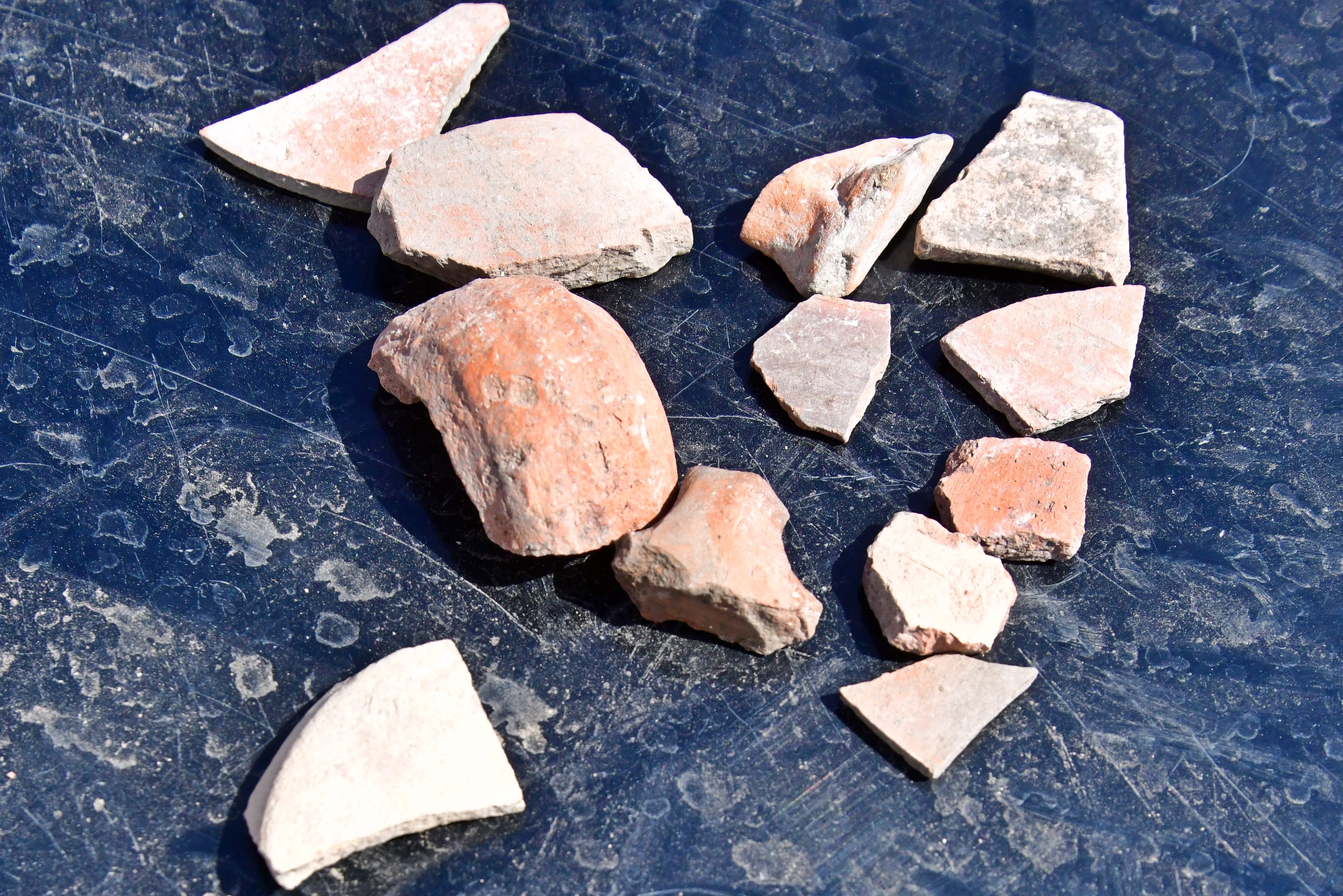
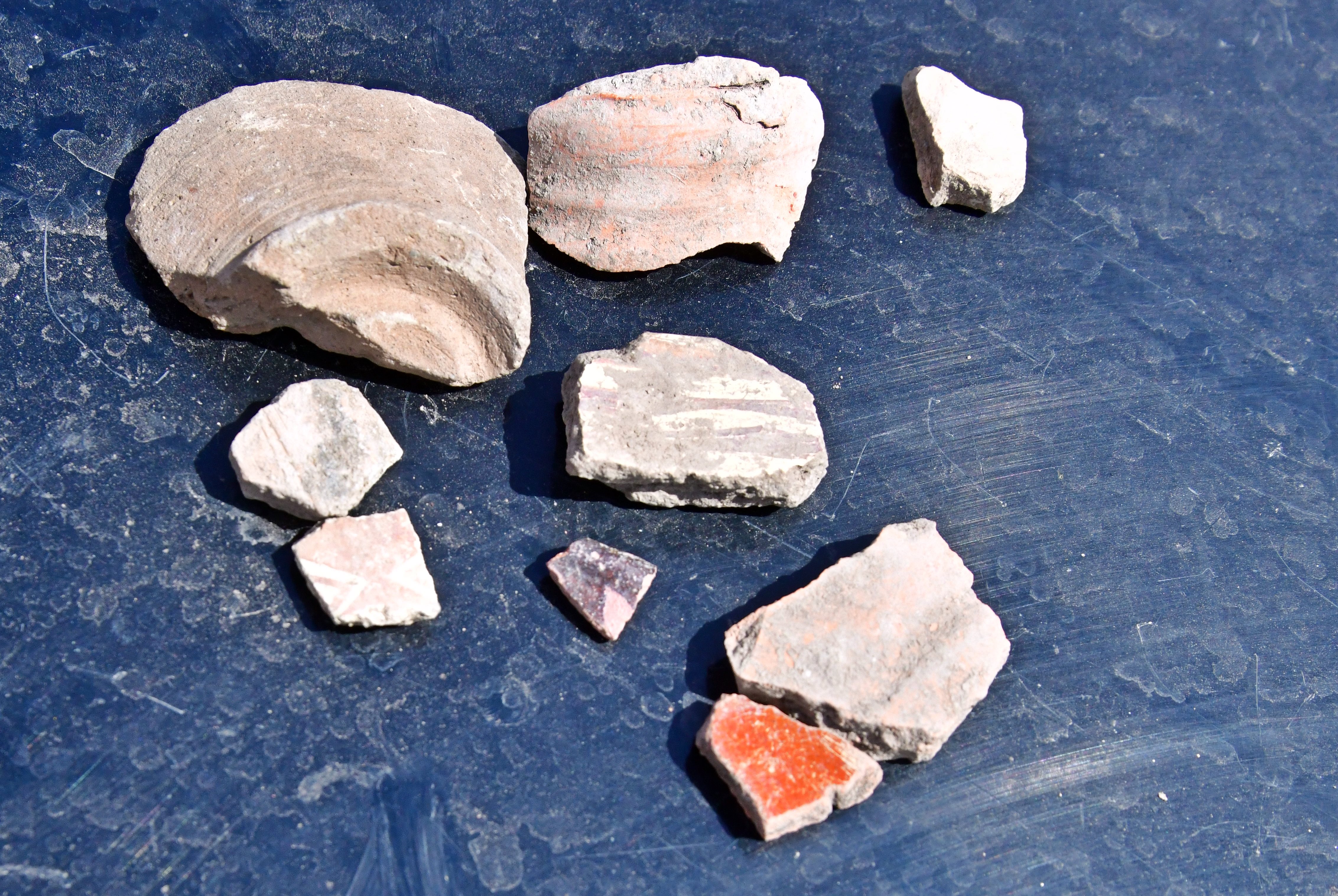
(e) Ceramics
In our survey we dated the following periods (percentages are based on the total number of pottery fragments we have collected during our survey): Biblical periods: 60%, Roman/Byzantine period: 24%, Arab/Ottoman periods: 16%.
Following photos are the 3 sets of dated periods. All items were left on the site.
Biblical Bronze/Iron periods:
Roman/Byzantine period:
Arab/Ottoman periods:
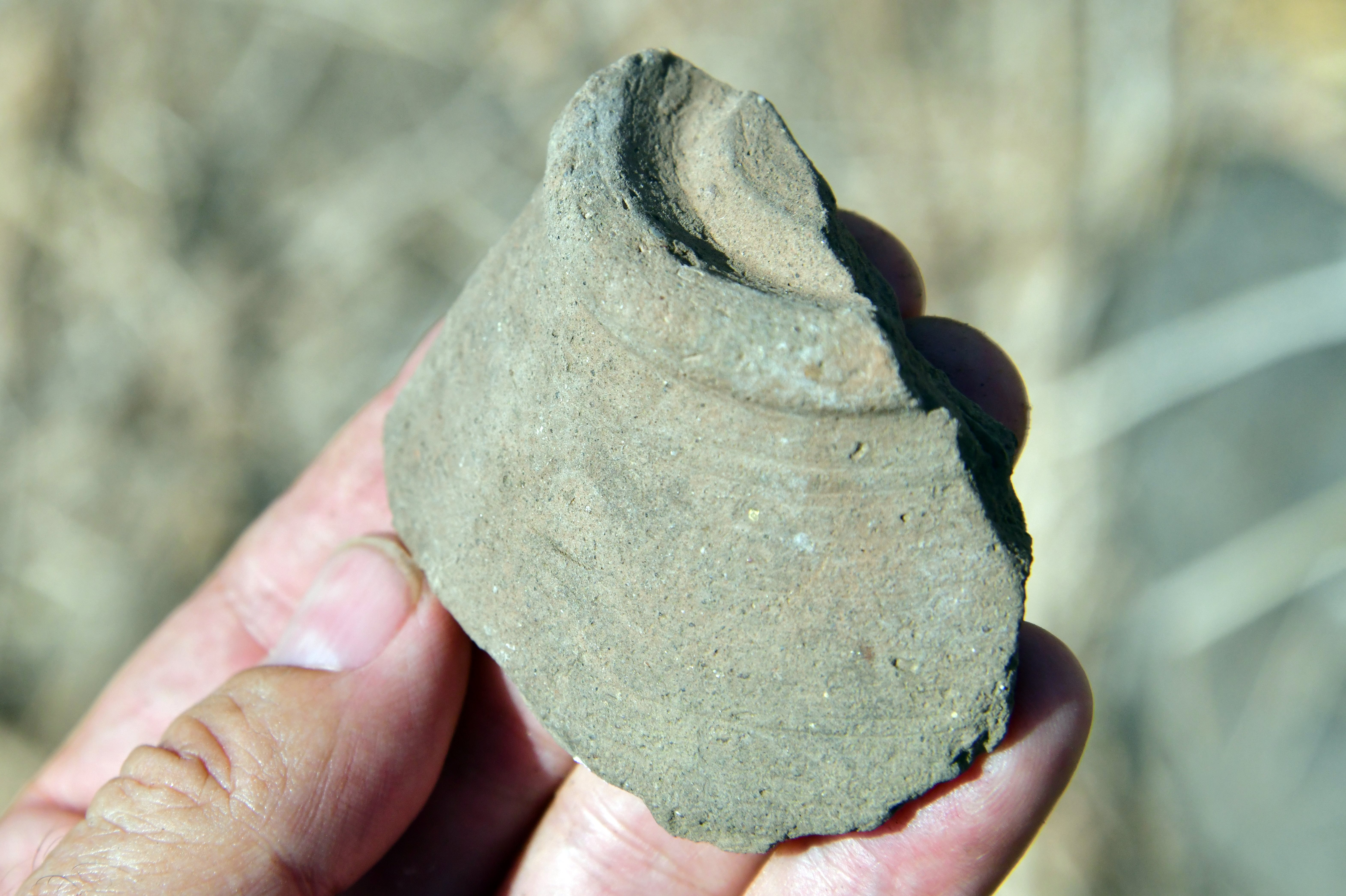
Samples of these pottery fragments are detailed here:
A Biblical period vessel (Iron Age II):
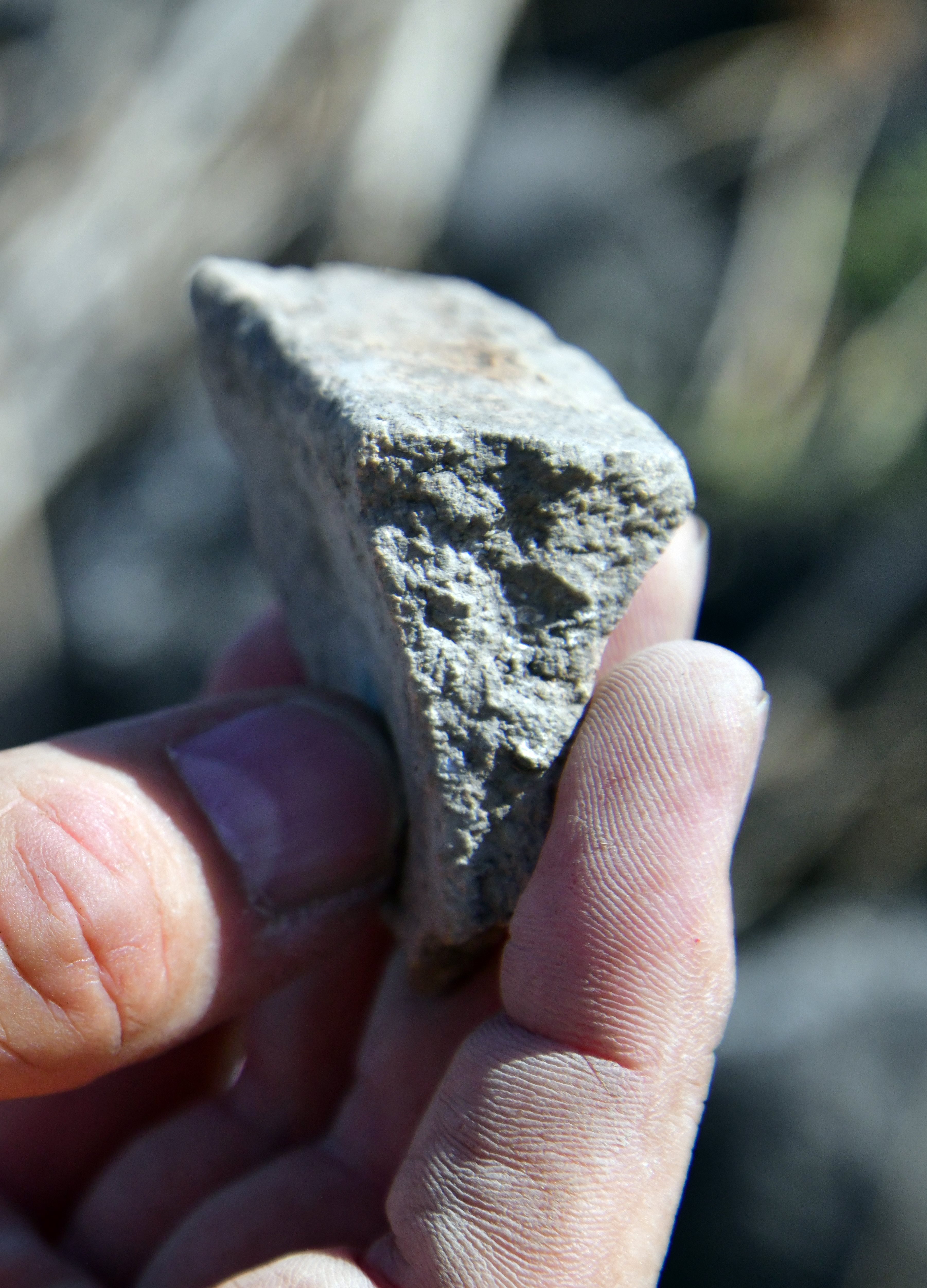
An Arab/Ottoman period vessel:
(f) Basalt tools
The local stones in this area are hard basalt stones. They were used to build the bases of the walls and also were used to create tools.
We found several of basalt tools, dated to the Bronze or Iron age period. The examples below are a grinding stone bowl and a flat rubbing stone:
(g) Aqueduct
The Berniki Aqueduct, also known as the Berenice Aqueduct, is an ancient water system that supplied water to the Roman city of Tiberias in northern Israel. The aqueduct transported spring water from the upper Nahal Yavne’el valley. Starting from the Ein Ran spring in an upper position of the valley, the aqueduct conveyed waters along a distance of over 11 km, with a shallow gradient.
Sections of the Roman period built aqueduct to Tiberias are visible along the south and east foothills of Horvat Kush.
The western walls of the canal are preserved in several sections. The wall is covered by a thick layer of hydraulic lime plaster in order to seal the water.
Note that the archaeological meter has 10cm bars.

A closer view of the plaster wall is seen below The plaster fragment detached from the wall, and has a reddish color.
Another section of the aqueduct, 100m upstream, was better preserved. This section curves around the hillside and gently ascends towards the springs. A typical width along the aqueduct was 110cm. Its base was 2-3m wide, made of unhewn basalt field stones.
Etymology – behind the name:
* The name of the site:
- Horvat Kush – modern Hebrew name, based on the Arabic name.
- Kush may refer to cannabis, perhaps based on the full Arabic name KhushKhush meaning ‘poppy’.
- Kush was also an ancient kingdom in Nubia, and the Bible refers Kush to East Africa.
- Kush was also the grandson of Biblical Noah.
- Lakkum (or Lakum) – Horvat Kush may be identified as this Biblical place mentioned in Joshua 19:33, based on the geographic order of sites in Naphtali tribe’s border. The name Lakum (לקום) literally means in Hebrew “to rise”, or implies “fortification.” (as per Holman Bible Dictionary Transliteration of modern translations).
- “Khirbet el Khushsha” (on British map) – Arabic, may mean: the place of fear .
- “Kh. el Mansurah” (on PEF map) – Arabic for the “ruins of victory”.
* The name of the valley and stream:
- Yavne’el (Jabneel) – Hebrew for “God will build”; (Joshua 15:11): “And the border went out … unto Jabneel”
- Nahal Yavne’el – Hebrew: Yavn’ele stream; named after the Biblical and Modern settlement
- Wadi el Fejjas – Arabic name of Nahal Yavn’el; PEF dictionary: “The valley of the haughty oppressor”.
Links and references:
* External links:
- “The Boundary between Issachar and Naphtali” – Aapeli Saarisalo – 1927 pp. 50-51 – reviews the site
-
Kinneret, the Berenice Aqueduct to Tiberias – HAESI Volume 120 Year 2008, Final report, Yardenna Alexandre
* Internal links:
- Horvat Kush survey – Biblewalks video (41 minutes)
- Aqueducts – information page
- Horvat A-Dir – nearby site, another Iron Age fortress
- Jordan Valley Archaeological survey– Biblewalks survey summary
BibleWalks.com – walks along the Jordan river
Aenon Near Salim<<<—previous site—<<<All Sites>>>—next Jordan Valley site—>>>Horvat A-Dir
This page was last updated on Dec 19, 2024 (add drone photo)
Sponsored Links: