Horvat Baat (Khirbet el Bawati) is a ruined village dated to the Roman/Byzantine and Early Arab period. It is located on the side of the imperial Roman road from Tiberias and Gadara to Beit She’an Scythopolis.
Home > Sites > Jordan Valley> Horvat Baat (Khirbet el Bawati)
Contents:
Overview
Aerial Map
History
Photos
* The Ruin
* Ancient Road
* Synagogue
* North side
* Ceramics
* Flight over
Links
Etymology
Background:
Horvat Baat, also known as Khirbet el Bawati, is an archaeological site located in Israel. The site contains remains from different periods, including the Roman, Byzantine, and Early Islamic eras. Horvat Baat is noted for its ancient synagogue, which dates back to the Late Roman or Byzantine period.
The village was situated along the side of the ancient imperial Roman road that connected Tiberias to Beit Shean (Scythopolis). This road was a significant route during the Roman and Byzantine periods, facilitating trade, military movements, and cultural exchanges across the region. The proximity of Horvat Baat to this major road would have made it an important stop or settlement.
Map / Aerial View:
The aerial map below shows the ruins spread to the east of highway #90. The village was built on a basalt ridge, 2.5km south of Nahal Issachar, 1km north of Nahal Harod, and 2.5km west of the Jordan river
History:
- Prehistoric periods
A Neolithic site was excavated in 1958 (N. Zori) and 1964 (J. Kaplan) on the eastern foothills of nearby Kibbutz Hamadia. It covered an area of 100m² and was dated between 5800-5400 BC. The archaeologists found on this single layer settlement: ovens, pits, fireplaces, and Yarmukian pottery -(a Pottery Neolithic A culture). No building remains were found, but a large flint workplace was found outside of the site with an estimated 300 sickle blades.
During the Neolithic period, the site was located on the shore of an ancient lake (lake Beisan), that covered the levels of -200m (under sea level) and below. This prehistoric fresh water lake existed between 12,000 to 5,000 BC, stretching between the sea of Galilee and wadi Malih. The lake resided thanks to the formation of the Jordan river. The lake turned to a swamp during the Chalcolithic period, and finally disappeared by the Middle Bronze period.
- Bronze and Iron (Biblical) Age
The cities and roads during the ancient periods, up to the Roman period, are indicated on the Biblical Map below. The site is on the path of a major south/north ancient road along the Jordan valley, depicted here as a grey dashed line (Dorsey’s Bronze/Iron age route ‘A3’). It is not far from the Jordan river, as illustrated as a blue line, where a river crossing crossed the ford to the eastern side of the river.
Map of the area around the site -from the Canaanite/ Israelite periods to the Roman period (based on Bible Mapper 3.0)
Ruins of an Early/Middle Bronze site, named Kh. Wadi el Khuneizir, is located north east of Hamadia, adjacent to the highway #90.
-
Roman and Byzantine period
During the Talmudic period, this was a Jewish village. Remains of a synagogue were found on the upper side of the site.
A major Roman road passed on the east side of the village. Many milestones of this imperial road were found around Beit Yosef, the nearby community on the north.
A section of the Peutinger map (Peutingeriana tabula), based on a 4th century map of Imperial Roman roads, is here below. It is oriented with the top side as the west. The map shows the major military roads between Jericho (on the middle left, named here by its Roman name – “Herichonte”), though Beit Shean (“Scytopoli”) to Tiberias ( “Tyberias”) above the icon of the Sea of Galilee. The distances are marked with Latin numbers, being XXIII (which means 23 Roman miles, or 35KM, between Beit Shean and Tiberias). The site is marked along this road as a red circle.
Section of the 4th Century Peutinger Map, focusing on the Jericho-Beit Shean-Tiberias road
A group of 5-6 milestones, of the Tiberias-Gadara-Scythopolis imperial road , were found 1km north of the site, adjacent to highway #90. One of the milestones was erected during the time of emperor Commodus (2nd century AD). P. Thomsen (1917) described a milestone of the 3rd Roman mile from Scythopolis from the time of Constantine I (292-306 BC).
The proximity of Horvat Baat to this major road would have made it an important stop or settlement, likely contributing to the site’s development and the presence of a synagogue. The road itself was a crucial artery in the Roman transportation network, linking key cities in the Galilee and the Jordan Valley, and connecting with broader routes across the Roman Empire. The site’s location along this route underscores its strategic and economic importance in antiquity.
After the Arab conquest most of the Roman road network fell apart. However, this road continued to be maintained and used as it serviced the route from the important link between Damascus and Cairo.
- Early Arab period
According to the ceramic survey, the village continued to be settled in this period.
-
Ottoman period
A Bedouin tribe, Bawati, set up mud houses in the ruined Byzantine village, reusing the ancient stones. The village, named ‘Arab al-Bawati, was later deserted in 1948. These Bedouins were a branch of the ‘Arab al-Ghazzawiyya Bedouin tribe, who were centered in Al-Ghazzawiyya, a village 2km east of Beit Shean.
The site was examined in the PEF survey (1866-1877) by Wilson, Conder and Kitchener. A section of their map is seen here. The map is part of sheet 9 of their survey results. The site appears in the middle of this section, named “Khirbet el Hakeimiyeh” (meaning in Arabic – the ruin of the wiseman” and also “Umm esh Sherashiyeh”. Their report was (SWP Volume 2, sheet IX, p. 122):
“Khurbet el Hakeimiyeh —Ruined walls and a few modern deserted houses—a small deserted village”.
An aqueduct is seen bringing water from the Nahal Harod river (“Nahr Jalud”), named Kanat Umm Heil. The PEF report described it (SWP Volume 2, sheet IX, p. 116):
“Kanat Umm Heil—A canal made apparently for purposes of irrigation, and not lined with masonry”.
Part of map sheet 9 of Survey of Western Palestine,
by Conder and Kitchener, 1872-1877.
(Published 1880, reprinted by LifeintheHolyLand.com)
Notice in the map that near the site are several river crossings: Makt. Abdallah and Makt. Abarah. These crossings were on foot at convenient points where the flow of the Jordan river slowed down and allowed walking on the river bed.
The map also shows a double-dashed road that passed east of the mound, marked as a Roman road. Its route follows the same route as the modern road #90.
- Ottoman Hejaz Railway
The Ottomans built a section of the Hejaz (Hijaz) railway from Haifa to Damascus, Syria, more than 100 years ago (in 1905). This railway linked the city and harbor of Haifa to Turkey and Medina (Arabia) until the Independence of Israel in 1948. Since then, it was dismantled and only few of the original rail sections could be seen.
The Ottoman railway, now dismantled, passed on the hills west of the site. It is shown as a dark solid line to the left of the modern highway #90.
-
British Mandate
The site was named in the British period maps as “khirbet Bawati”, named after the Bedouin tribe that lived in this area (named El Bawati). In this section, the ancient road is seen as a dashed line on the side of the buildings. An aqueduct (Qanat el Hakimiya, indicated by a continuous line) is seen in parallel and east to the road.
British survey map 1942-1948 – https://palopenmaps.org topo maps
License: public domain under the UK Copyright, Designs and Patent Act 1998
- Modern Period
The site has not been excavated so far. It is on a public area, easily reached by a farm road. On the east side of the road are greenhouses with bananas, and on the west side are dry remains of a fish pond. Highway #90 (Tiberias-Beit Shean) passes on the west side.
Photos:
(a) The Ruin
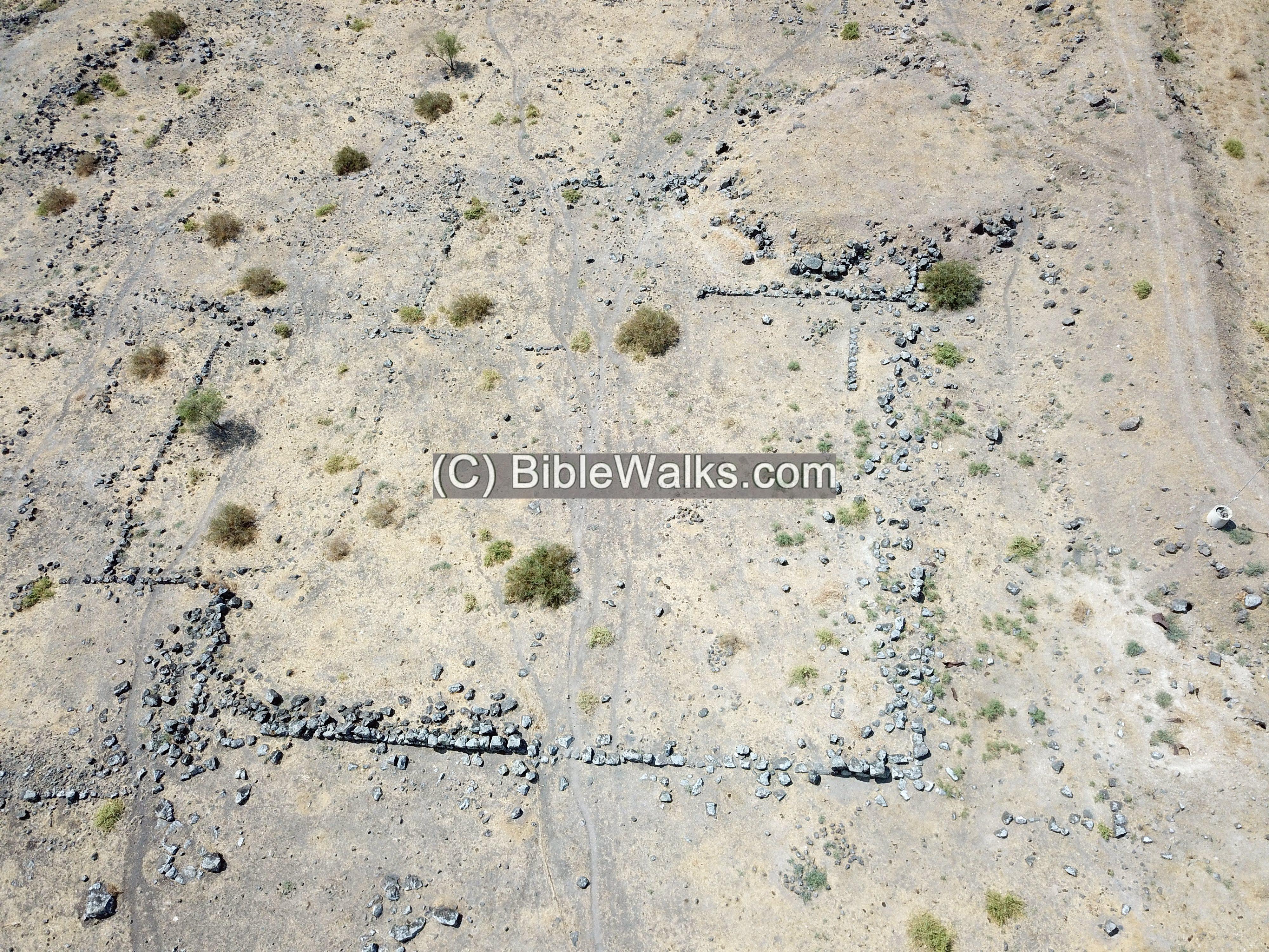
The ruins cover an area of 250 dunams (roughly 500m by 500m).
Traces of walls and bases of structures, made with basalt stones, cover the area.
Among the stones are architectural elements.
There are visible bases of dozens of rectangular structures spread in the area.
One of the structures we noticed has a divided wall along the length of the structure – perhaps a stable.
A drone view, oriented towards the east, shows the central section of the ruined village.
The following photo is a view towards the west. In the left far background are the hills of Mt. Gilboa. The green area before it is Kibbutz Hamadia, 2km south west of the site.
On the right far background are the hills of Ramat Issachar. On its foothills is the course of the Ottoman railway, connecting to the bridge at old Gesher river crossing.
b) Ancient Road
A major Roman road passed on the east side of the village. It was in use until the Ottoman period.
The course of the ancient road is visible along a kilometer on the eastern side of the village. It is about 3.5m wide, and lined with stones on both sides. In some places there are ditches on the sides of the road.
This is a view towards the south:
A section of an unmarked milestone lies nearby.
An aerial view of a section of the road is seen here curving around the ruin. This view, captured on Aug 2024, is towards the south.
Many milestones of this imperial road were found around the nearby community of moshav Beit Yosef (3km to the north). In front of one of the houses are two milestones, found by a local farmer in the 1980s. (More on milestones: Tel Issachar)

c) Synagogue
Ruins of a Byzantine period synagogue were found in Horvat Baat. It measured 15 by 25m and was oriented north-south.
However, we did not yet find this structure among the ruins.
d) North side
On the north side of the settlement are large areas bounded by walls. One of them, measuring 40m by 40m has extra large walls.
This may have been a fortress that protected the road.
A detail of the south western corner, as seen during another time.
An aerial view of this structure is seen here, looking towards the south:
e) Ceramics and more
N. Zori (1962) dated the ceramics to additional periods: Persian, Byzantine and Early Islam. Few pottery fragments were dated to earlier periods.
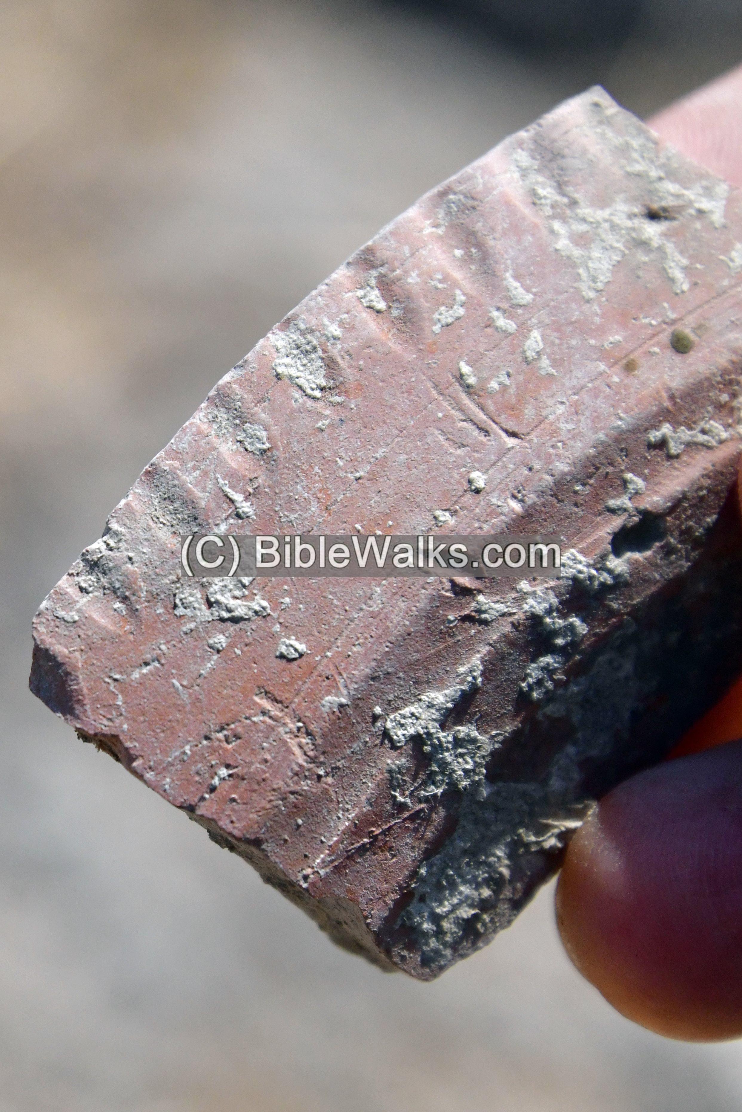
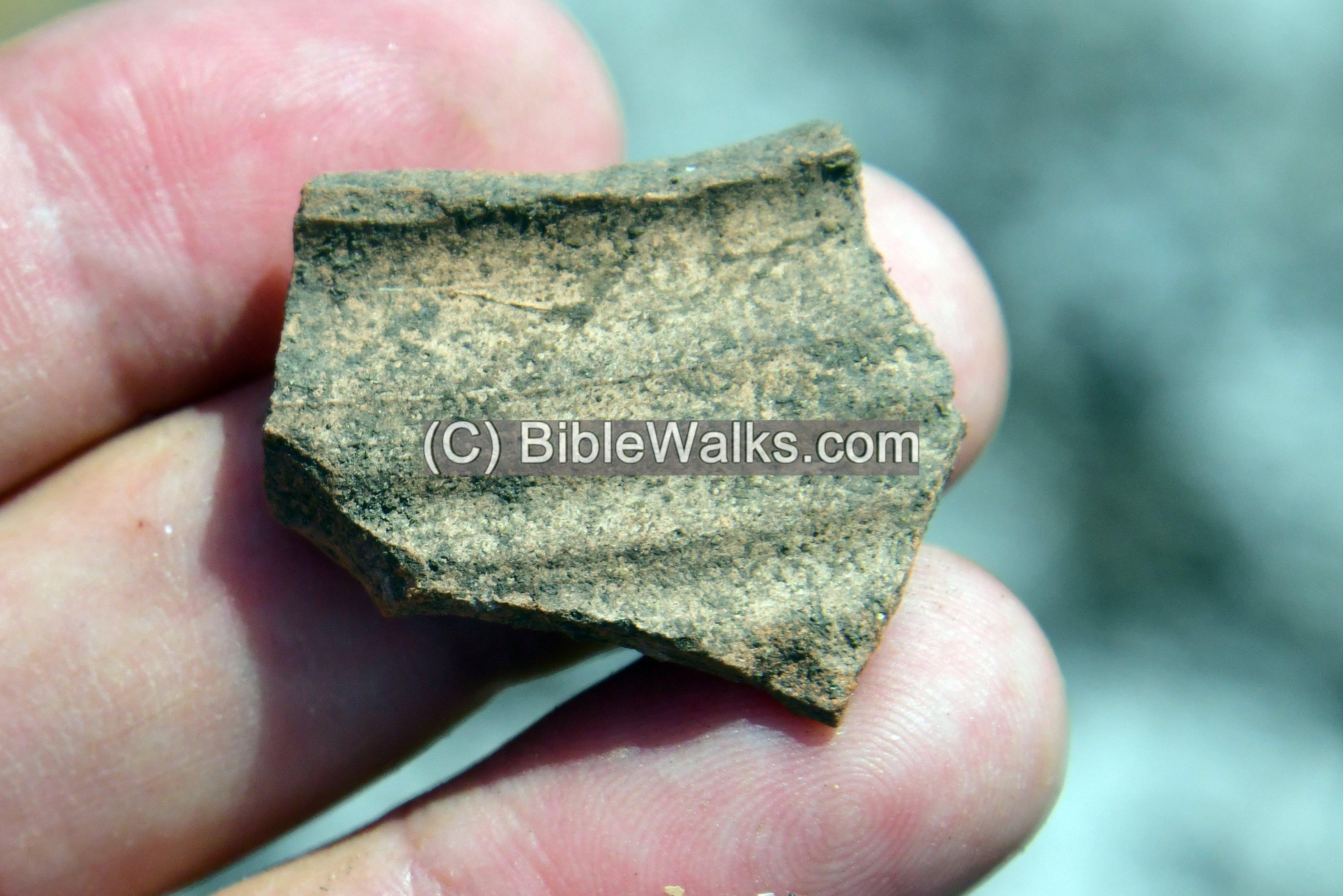
During our short survey, we identified the following fragments:
a. Roman period plate
b. Byzantine period vessel
c. Early Arab colored ceramic
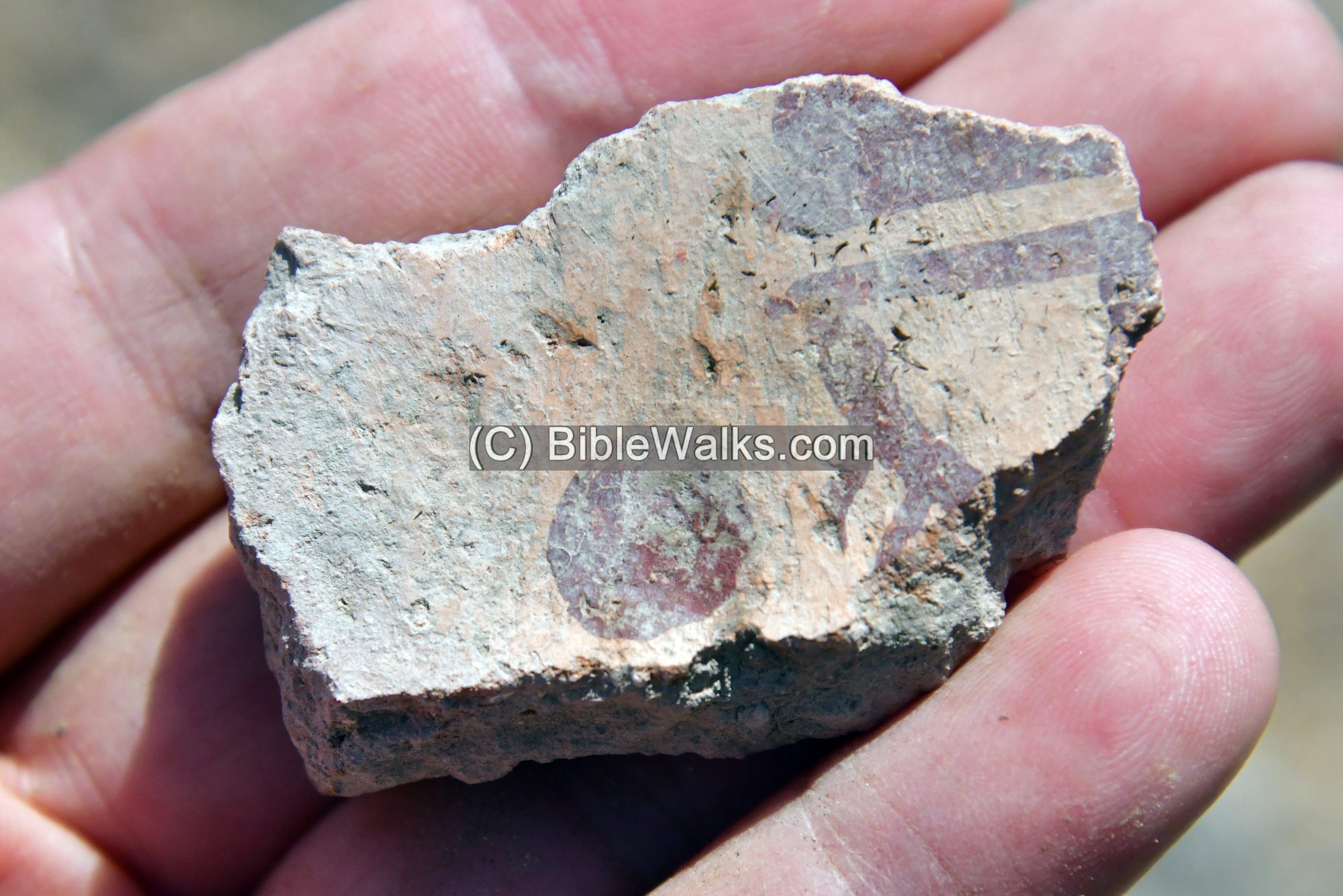
d. Yet another Early Arab colored ceramic
Metal objects:
We noticed an ancient horse riding stirrup made of one piece of iron, probably dated to the Ottoman or Mameluke period. Stirrup, a light frame or ring that holds the foot of a rider, and attached to the saddle by a strap, arrived to the Levant only in the 8th century AD.
(e) Flight Over
![]() Fly above and around the site with this YouTube video. The drone starts from the east side, flies over the site, and turns.
Fly above and around the site with this YouTube video. The drone starts from the east side, flies over the site, and turns.
Video captured on Aug 2024
Links:
* External links:
- N. Tzori 1962 – Doshen (Khirbet Bawati) – site 42
- Yarmukian culture Y. Garfinkel, 1993
* Internal links:
- Aqueducts – information page
- Tel Issachar – nearby site
- Roman roads – info page
- YouTube – BibleWalks’ aerial views
Etymology – behind the name:
- Khirbet Bawati- named after the Bedouin tribe that lived in this area.
- Khurbet el Hakeimiyeh – the name on the SWP map. Hakeimiyeh – a family name (as per PEF dictionary).
- Umm esh Sherashiyeh. Other name of the site, meaning: Mother of shrubs ; a tree (as per PEF dictionary).
- Horvat Baat – Hebrew modern name; בעת means fear.
- ‘Ain es Soda. The black spring.
- Kibbutz Hamadia (Hamadiya) – founded 1939, re-established 1942; name is based on a deserted village named for Abdul Hamid II, a sultan of Ottoman empire
BibleWalks.com – walks along the Jordan river
Tel Zemed <<<—previous site—<<<All Sites>>>—next Jordan Valley site—>>>Tel Shalem
This page was last updated on Aug 10, 2024 (new site)
Sponsored Links: