Dead Sea Works is a large potash plant on the south side of the Dead Sea, near Mt. Sodom (Sedom).
Home > Sites > Dead Sea > Dead Sea Works, Sodom (Sedom)
Contents:
Background:
The Dead Sea Works potash plant is located on the south side of the Dead Sea, near the mountains of Sodom (Sedom).
The mountains of Sodom are located to the west of the plant, rising 150-250m above the Dead Sea and 200m below the Mediterranean Sea. The steep cliffs reach about 250m from the shore of the Dead Sea. The mountains, 11KM long and 2KM maximum width, are made of salt mixed with other minerals.
Location and Map:
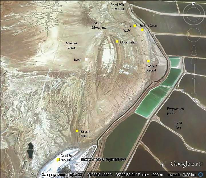
The Dead Sea Works and the mountains of Sodom (Sedom) are located on the south-west side of the Dead Sea, along road #90, as illustrated in the aerial map. They start from the Dead Sea Works plant, and extend 11KM to the north up to Zohar brook.
History:
-
Geological history
The Dead Sea is part of the Great Rift Valley (Syrian-African depression), which runs from northern Syria to the South East Africa (6,000 KM long). It started to evolve 25 Million years ago, due to tectonic pressures of plates. At that time the depression, in this section, was covered by Ocean water.
Due to the heat and dryness of the area, the water evaporated, and salt accumulated at the bottom of the lake. About 2 million years ago the depression at the area of the Dead Sea was cut off from the Ocean, and a great lake was formed. The accumulation of salt formed a large body of accumulated salt on the bottom of the lake.
Over the years, the salt deposits reached to a large size, with a depth of 5-6 kilometers, 8-12 KM wide and 40KM long. Later, other kinds of heavier minerals and rocks accumulated over the layers of salt. Their pressure on the body of the salt caused the salt layers to push sideways.
The salt body slid 1-2KM towards the edges, rising above the “younger” rocks on the edge of the cliffs.
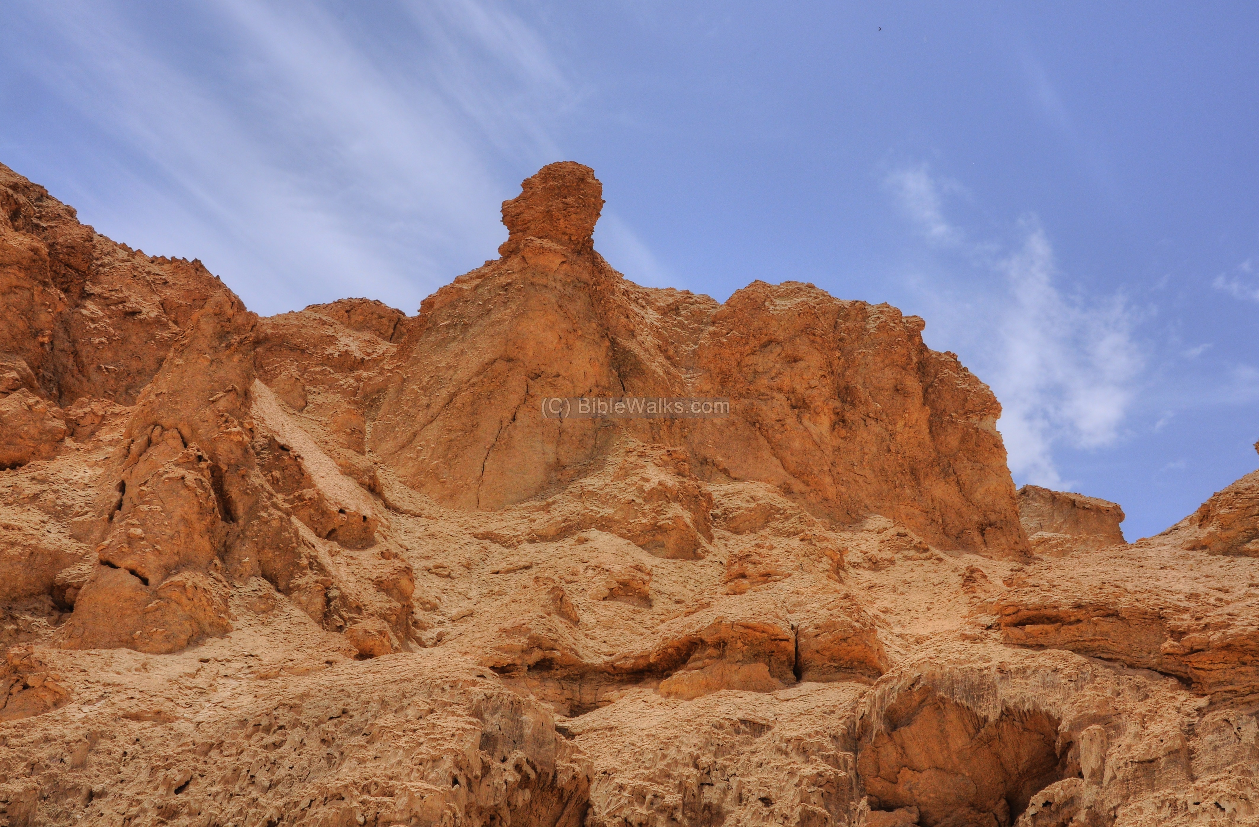
Mt Sodom is the result of this push west and upwards. Over the years some of the salt melted and washed away, mixing with the rock and creating many cavities and channels that poke the mountain.
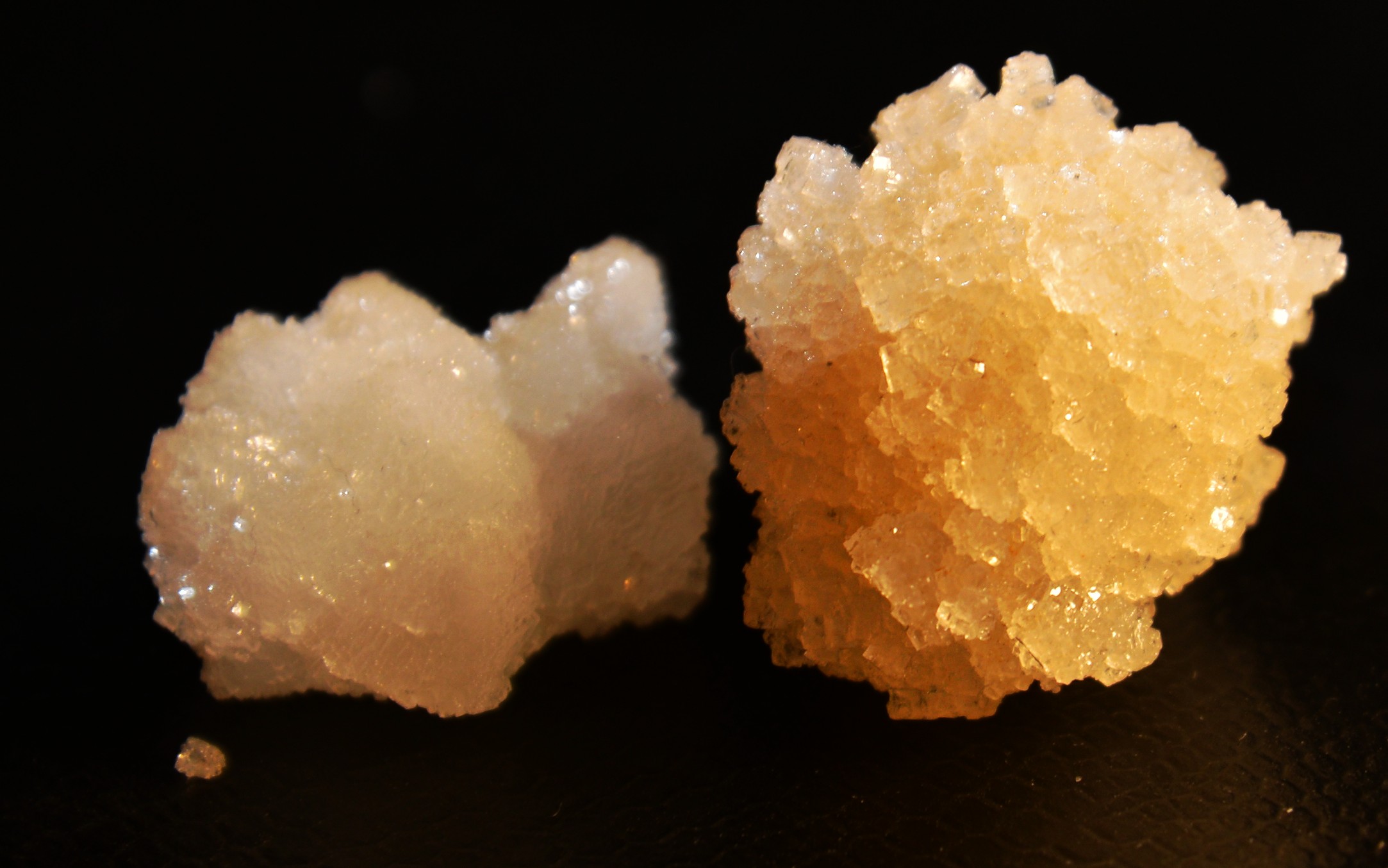
Chunks of Dead Sea salt, found on the floor of the sea
-
Biblical times
The cities and roads during the early periods are indicated on the Biblical Map below. The site of the modern plant is on the south-west side.
There were few cities during this time:
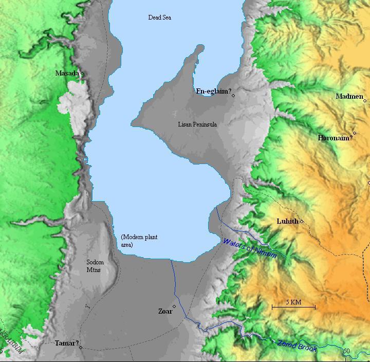
Zered Brook – the valley of Wadi Hasa is identified as the Zered brook. In the Biblical times this was the boundary between Moab and Edom, and the Israelites crossed it on the 38th year along the voyage to the promised Land (Deuteronomy 2, 13-14): “Now rise up, said I, and get you over the brook Zered. And we went over the brook Zered. And the space in which we came from Kadeshbarnea, until we were come over the brook Zered, was thirty and eight years; until all the generation of the men of war were wasted out from among the host, as the LORD sware unto them.”
Zoar – the city in the valley of Zered brook, probably at the location of the ruins of Tel Sheikh ‘Isa, near the village of Safi. It is mentioned in the Bible in connection to the departing of Abraham and Lot (Genesis 13:10): “And Lot lifted up his eyes, and beheld all the plain of Jordan, that it was well watered every where, before the LORD destroyed Sodom and Gomorrah, even as the garden of the LORD, like the land of Egypt, as thou comest unto Zoar“. Zoar is mentioned again in the fight between the 4 kings of Aram-Naharaim and the 5 kings of the Dead Sea area, here named the “valley of Siddim” or the “Salt Sea” (Genesis 14 2-3): “That these made war with Bera king of Sodom, and with Birsha king of Gomorrah, Shinab king of Admah, and Shemeber king of Zeboiim, and the king of Bela, which is Zoar. All these were joined together in the vale of Siddim, which is the salt sea”. Later, Lot fled to Zoar after Sodom was destroyed (Genesis 19:30): “And Lot went up out of Zoar, and dwelt in the mountain, and his two daughters with him; for he feared to dwell in Zoar: and he dwelt in a cave, he and his two daughters”.
Map of the area around the south Dead Sea – during the Biblical through Roman periods (based on Bible Mapper 3.0)
Tamar – Israelite, Nabatean and Roman period fortresses located near the spring of Hazeva, identified as Biblical Tamara and Roman Tamara. See web page on this site.
Sodom (Sedom) – one of the two famous cities that were destroyed by God in the Dead Sea area (Genesis 19 28): “And he looked toward Sodom and Gomorrah, and toward all the land of the plain, and beheld, and, lo, the smoke of the country went up as the smoke of a furnace”. Its location is not known, yet in modern Israel the area of Sodom (Hebrew: Sedom) is located on the south-west side, where the Dead Sea Works plant is located.
-
Modern period
The Dead Sea Works plant was founded in 1930 by Mikhail (Moshe) Novomeysky, a mining engineer from Siberia. In 1907, the Russian engineer applied in 1907 to the Ottoman authorities for the permission of extracting the salt from the Dead Sea. He visited the Dead Sea in 1911, and immigrated to the country in 1920. After the British replaced the Ottomans, a tender was issued for the mining rights, and the permission was finally granted to the engineer in 1929.
The plant, the Palestine Potash Company, operated as a private company between 1930 and 1948. There were two plants – the first plant was constructed in 1930 on the north side of the Dead Sea, followed by the construction in 1934 of the main plant in the south-west.
The north plant was destroyed in 1948 during the Independence war. The south plant was nationalized by Israel in 1951 and renamed: Dead Sea Works (Hebrew: Mif’alei Yam Ha-Melakh).
The entry to the plant is only for authorized persons. However, you can ascend to the west of the plant, visit the large environmental sculpture and also drive to the observation point on the cliffs west of the Dead Sea.
Photos:
(a) The Dead Sea Works plant:
The Dead Sea Works, an Israeli fertilizer and chemical enterprise, is the World’s fourth largest producer and supplier of potash products, situated in the lowest place in the planet – the Dead Sea. The plant was founded in 1930, employs 1,500 staff directly and supports 20,000 indirectly, being 20% of the economy of the Negev region.
Potash is a natural salt which contains potassium, mainly used in agriculture fertilizers. The plant produces a variety of other chemicals as well, such as magnesium chloride and table salt, and raw materials for the cosmetic industry.
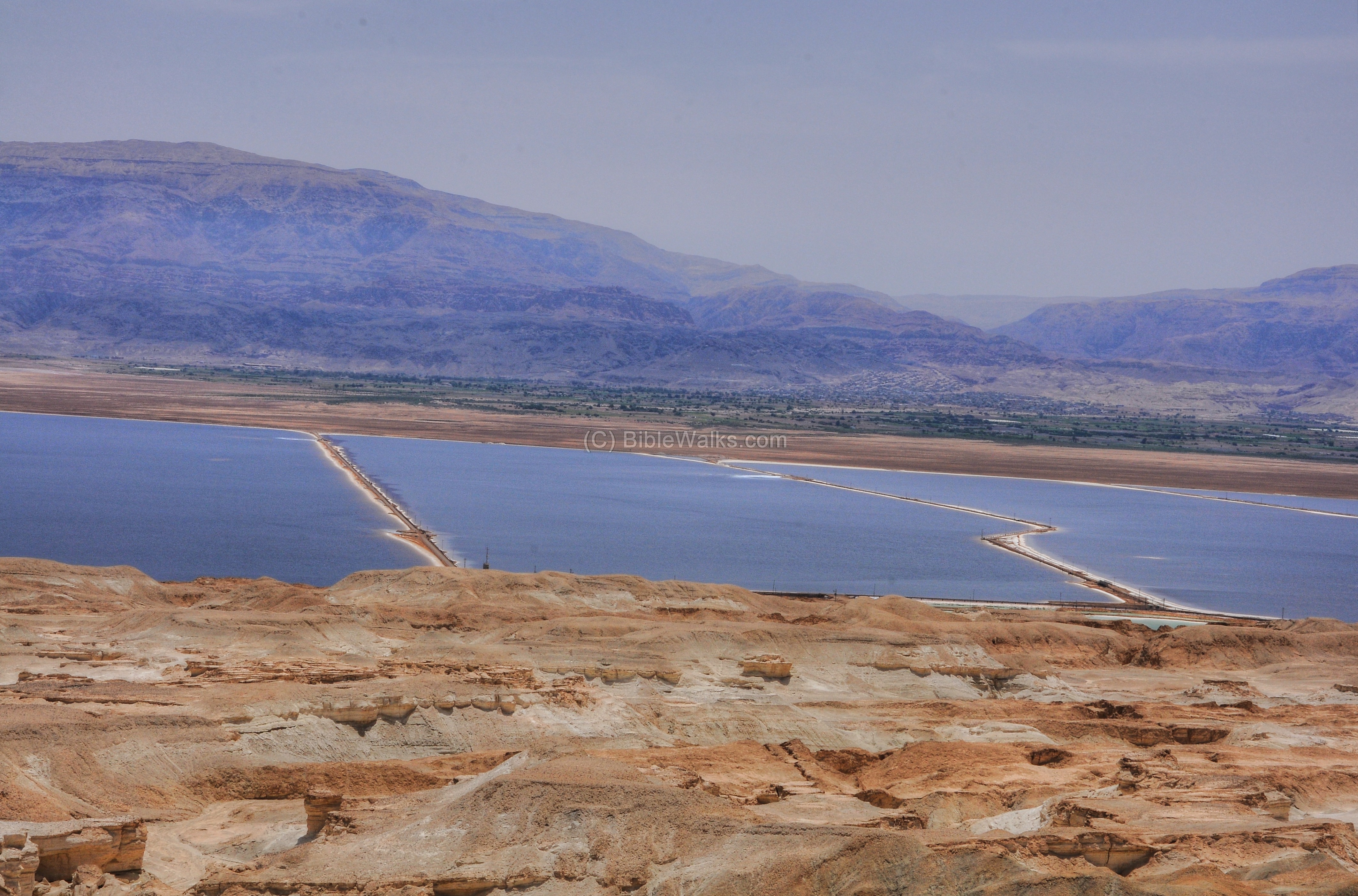
This picture is a view from the western hills above the main entrance to the plant, which is located in Sodom on shore of the the Israeli side of the southern Dead Sea.
Click on the photos to view in higher resolution…
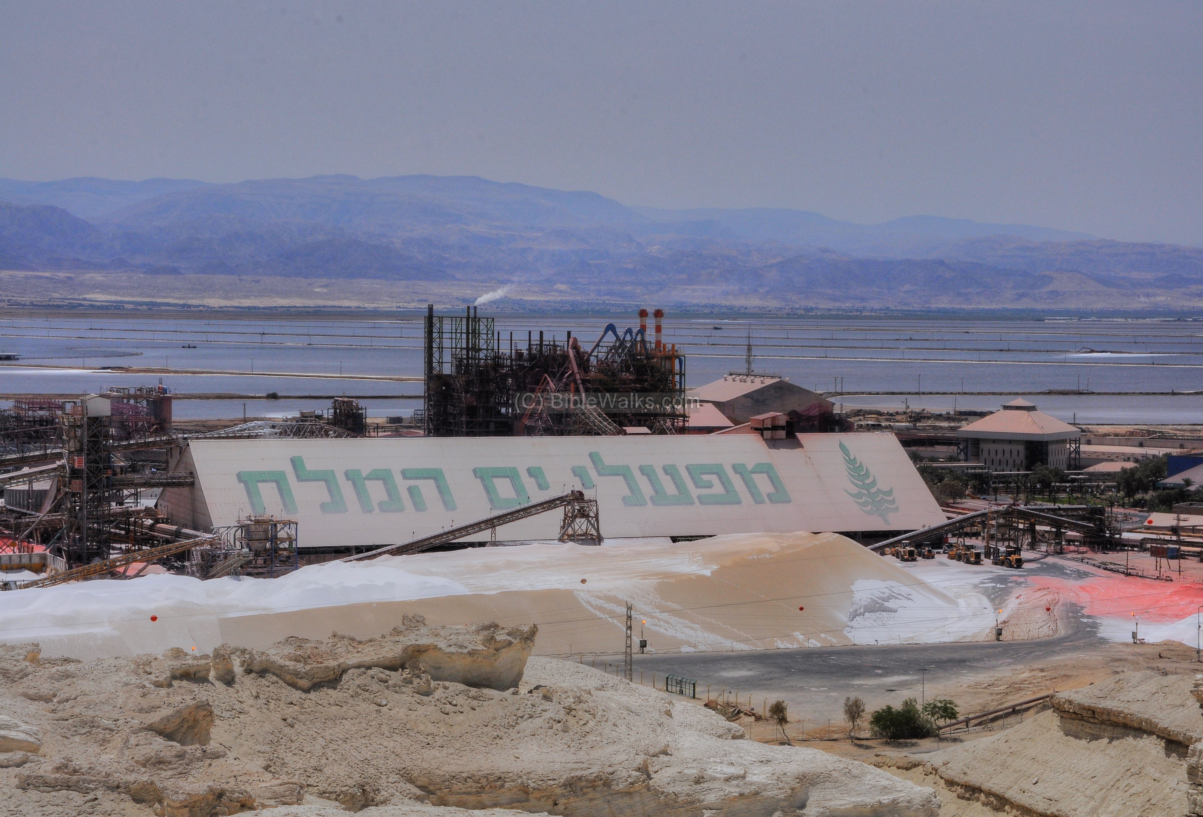
The Dead Sea is 10 times more saltier than other seas, having a 33% concentration of salt. This level prevents marine life, hence the name “Dead Sea”, but is rich in minerals which are exploited by the plant.
The pure potash and other minerals are extracted by evaporating the Dead Sea water in ponds, harnessing the energy of the sun. These shallow evaporation ponds were constructed in 1934-1936, and cover a vast area of the southern Dead Sea.
The Jordanian border passes on the dike in the middle of the ponds, and beyond it is the Jordanian potash plant.
On the right side of the picture is the “V” shape of the valley of Wadi Hasa (Hebrew: Nahal Zered), which is identified as the Zered brook.
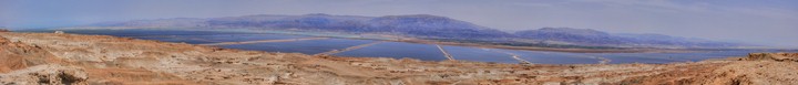
A panoramic view, as seen from the west side of the Dead Sea works, is shown in the following picture. If you press on it, a panoramic viewer will pop up. Using this flash-based panoramic viewer, you can move around and zoom in and out, and view the site in full screen mode.
To open the viewer, simply click on the photo below. It will open a new window after a minute or so.

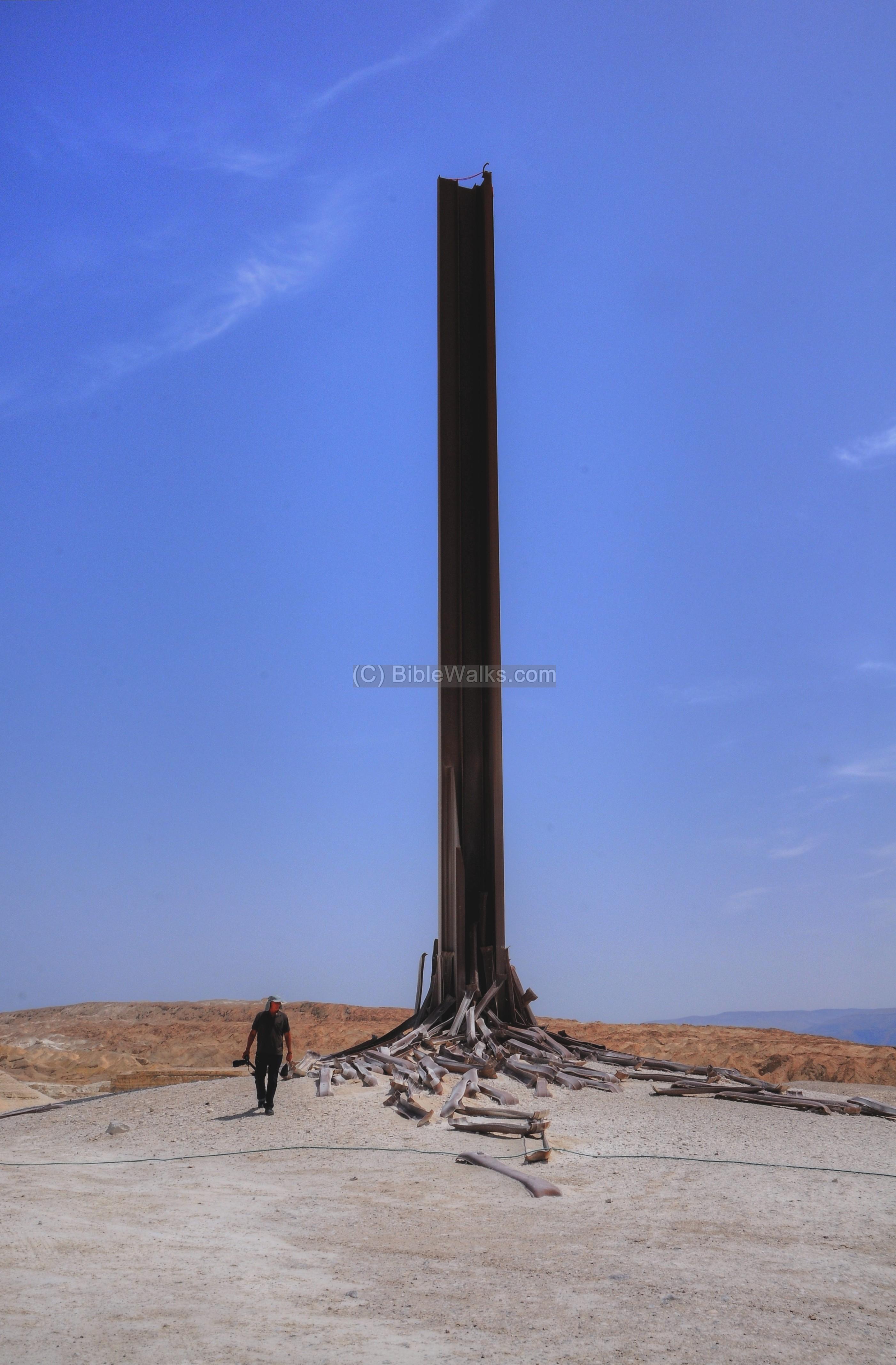
(b) Monument:
Overlooking the plant, from the cliffs on the west side, is a 25m high monumental sculpture called “The condition of Man”. The impressive metal structure was designed by the sculptor Ezra Orion (born 1934; lived in Kibbutz Ramat Yochanan and Sde Boker). The environmental sculpture is based on 236 railway sleepers, which were dismantled from the Haifa-East station.
(c) Mt Sodom (Sedom):
The mountains of Sodom (Sedom), 11km long and 2KM wide, are located to the west of the plant, rising 150-250m above the Dead Sea and 200m below the Mediterranean Sea. This section is located near the entrance to the plant. Beyond are the evaporation ponds, and in the background the mountains of Jordan.
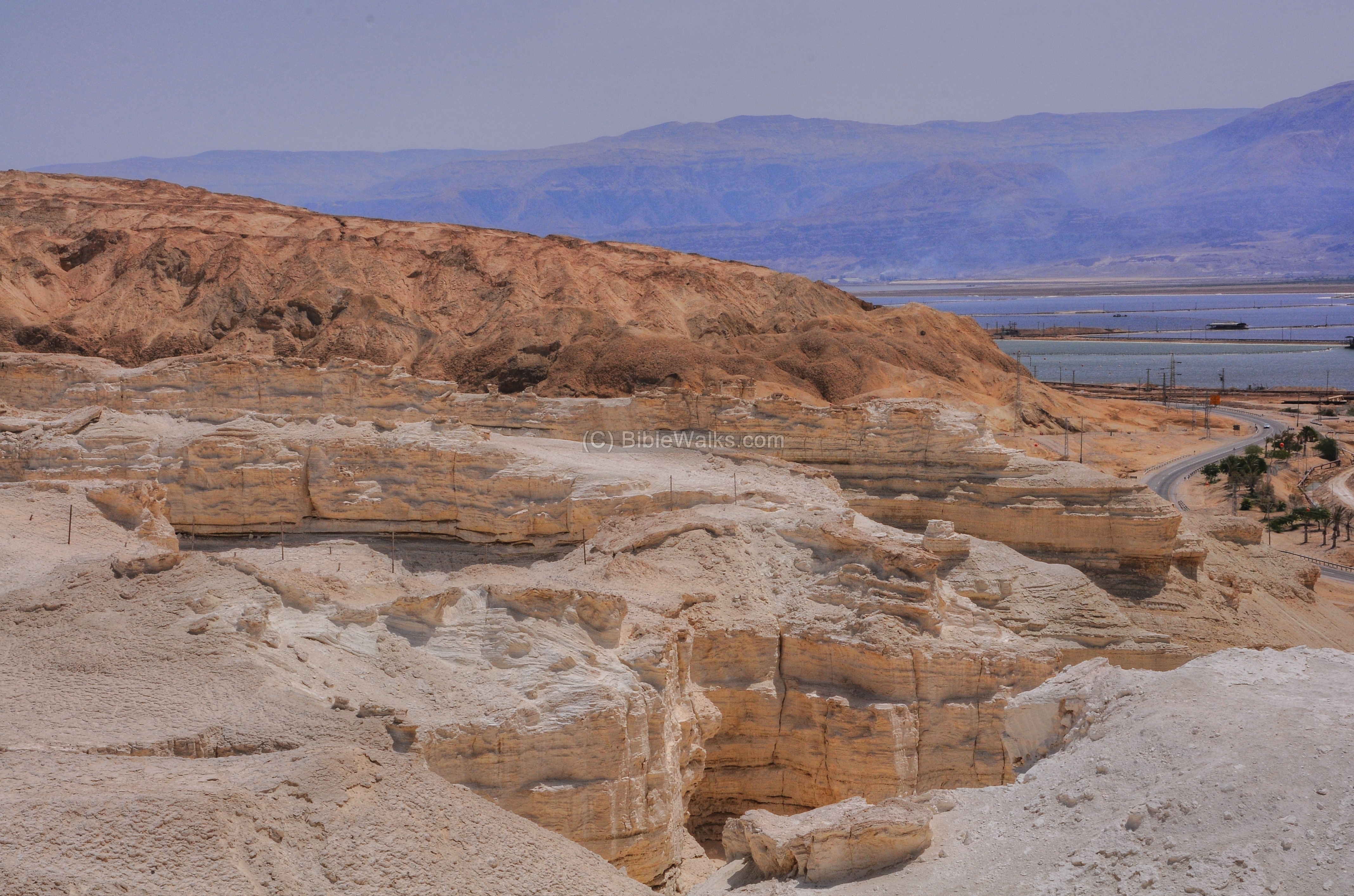
The formations in the salt based rock provide great views along the ascent to Mt Sodom.

There is an excellent observation point on the top of the cliffs. To reach there, drive towards the plains of Amiaz, a wide valley west of Mt Sodom, turn north and then back to the east.
A panoramic view, as seen from the cliffs above the Dead Sea works, is shown in the following picture. If you press on it, a panoramic viewer will pop up. Using this flash-based panoramic viewer, you can move around and zoom in and out, and view the site in full screen mode.
To open the viewer, simply click on the photo below. It will open a new window after a minute or so.
(d) Ladders Ascent:
Several Kilometers north of the Dead Sea works, along the #90 road, is a vista point and walking path named “the ladder ascent”. It is located near one of the Sodom caves, named “twin chimney”.
You can climb up the steps (hence the name) to an observation platform above the Dead Sea. The path continues up to the top of the mountain.

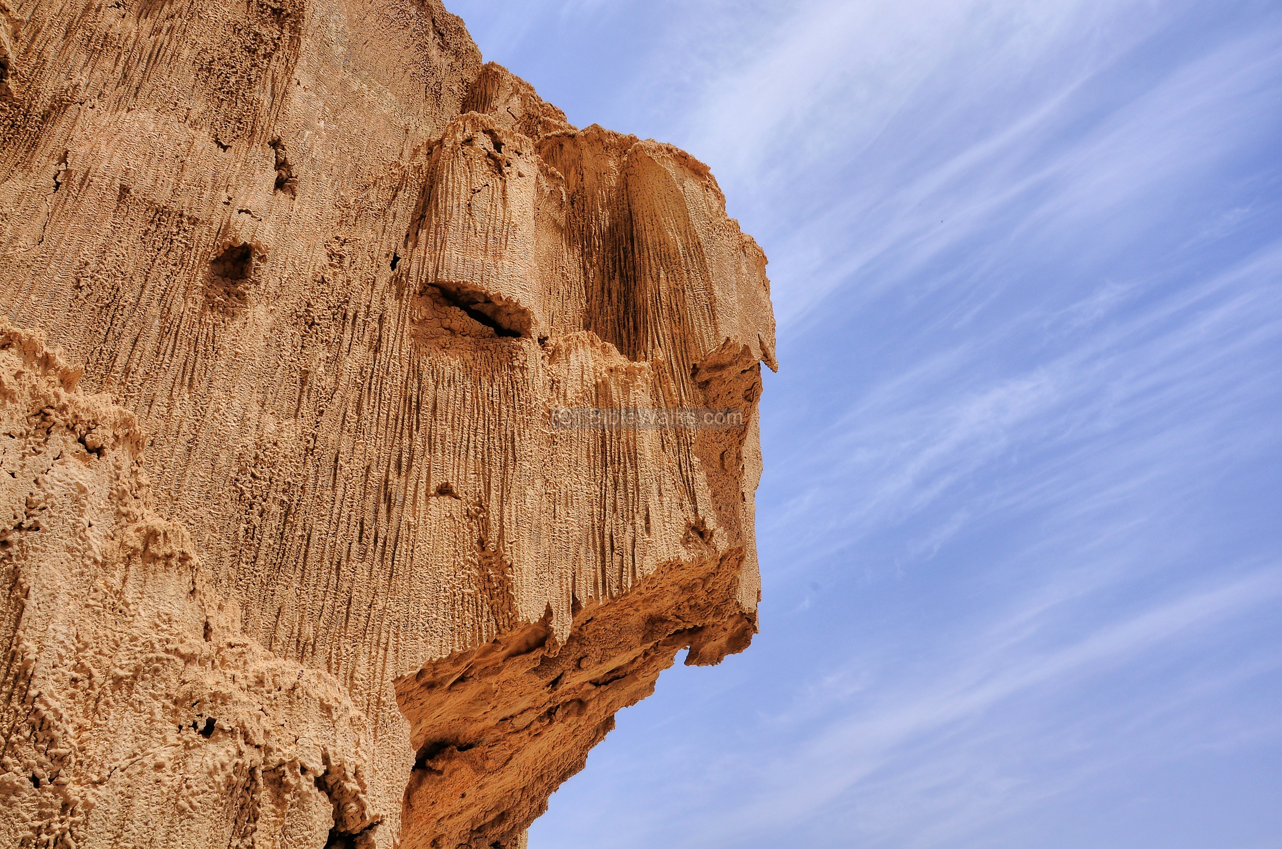
The sides of the ascent is carved into the cliff.

A side view of the cliff at the side of the ascent is seen in the next picture.
The site is facing the ruins of the old workers’ camp. The camp was established in 1934, and continued to be in use until 1948. A ship sailed from a pier on the north side of the camp, connecting the workers to the northern plant.
The camp was in use again from 1952 until its final closure in 1957.

Links and References:
* External links:
- Dead Sea Works – web site
- Ezra Orion – the sculptor (Hebrew; Haaretz 2012)
- Ladders Ascent tour (Hebrew, pdf 2 pages; describes a descent from the top to the Dead Sea)
* Internal links:
– Nearby sites:
- Dead Sea – Gallery of sites
- Sodom caves – more sites along Mt. Sodom
Etymology – behind the name:
- Dead Sea – name of the great lake east of the Judean desert. The lake is one of the saltiest (hence the lack of life) and the deepest in the world.
- Salt Sea – name in Hebrew (Yam= Sea, Melach – salt). Biblical reference: (Genesis 14 3): “All these were joined together in the vale of Siddim, which is the salt sea“. (Joshua 15:5): “And the east border was the salt sea, even unto the end of Jordan”.
- Jebel Usdum – Arabic name of the mountains of Sodom
BibleWalks.com – bringing the Dead Sea back to Life
Qumran <<<—previous site—<<<All Sites>>>—next Dead Sea site—> >> Sodom C aves
This page was last updated on Apr 12, 2013
Sponsored Links: